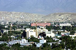
Wazir Akbar Khan, Kabul
Wazir Akbar Khan
وزیر اکبر خان | |
|---|---|
 | |
 Wazir Akbar Khan in northern Kabul | |
| Country | |
| Province | Kabul |
Wazir Akbar Khan (وزیر اکبر خان) is a neighbourhood in northern Kabul, Afghanistan, forming part of District 10. It is named after the 19th century Afghan Emir Wazir Akbar Khan. It is one of the wealthiest parts in Kabul. Many foreign embassies are located there, including the American and Canadian.[1] The Hamid Karzai International Airport is also located nearby Wazir Akbar Khan.
It is a common place for foreign workers to live. The streets are laid out on a grid with Western, two-story houses that date back to the 1960s and 1970s.[2] Like much of Kabul, the Afghan National Security Forces (ANSF) provide security for the area. Most of Afghanistan's national government institutions are located in the area, including the Presidential Palace, the headquarters of the Resolute Support Mission and the German-Afghan Amani High School. A Marriott Hotel is being constructed across from the U.S. Embassy.
Terminology
The neighborhood is named after Emir Wazir Akbar Khan, a prominent Afghan hero during the early 1840s, a son of Emir Dost Mohammad Barakzai. Akbar is Arabic for "great" and Khan means "chief/King" in Pashto.
In popular culture
The early part of the novel The Kite Runner by Khaled Hosseini is set in this suburb.
The second half of Max Ledman's novel Conspiracy takes place in this suburb.[citation needed]
References
- ^ "The Embassy of Canada to Afghanistan". Foreign Affairs and International Trade Canada. August 22, 2006. Archived from the original on 2008-01-14. Retrieved 2008-01-15.
- ^ Sacred Cows: Banana Republic
34°32′10″N 69°11′02″E / 34.536116°N 69.183869°E
