
Weedville, Alabama
Weed Crossroad, Alabama | |
|---|---|
| Country | United States |
| State | Alabama |
| County | Crenshaw |
| Elevation | 453 ft (138 m) |
| Time zone | UTC-6 (Central (CST)) |
| • Summer (DST) | UTC-5 (CDT) |
| Area code | 334 |
| GNIS feature ID | 157226[1] |
Weed Crossroad, also known as Weed or Weedville, is an unincorporated community in Crenshaw County, Alabama, United States. It is located on Alabama State Route 141, 5.1 miles (8.2 km) south-southeast of Brantley.[2]
References
- ^ "Weed Crossroad". Geographic Names Information System. United States Geological Survey, United States Department of the Interior.
- ^ General Highway Map: Crenshaw County, Alabama (PDF) (Map). Alabama Department of Transportation. 2007. Retrieved July 30, 2015.
{{cite map}}: Cite has empty unknown parameter:|trans_title=(help)
Municipalities and communities of Crenshaw County, Alabama, United States | ||
|---|---|---|
| Cities | 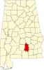 | |
| Towns | ||
| Unincorporated communities | ||
| Footnotes | ‡This populated place also has portions in an adjacent county or counties | |
This Alabama state location article is a stub. You can help Wikipedia by expanding it. |