
Westoverledingen
Westoverledingen | |
|---|---|
 Coat of arms | |
Location of Westoverledingen within Leer district 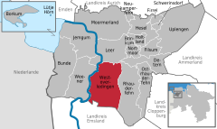 | |
 Westoverledingen  Westoverledingen | |
| Coordinates: 53°9′N 7°28′E / 53.150°N 7.467°E | |
| Country | Germany |
| State | Lower Saxony |
| District | Leer |
| Subdivisions | 14 districts |
| Government | |
| • Mayor | Eberhard Lüpkes |
| Area | |
| • Total | 111.9 km2 (43.2 sq mi) |
| Elevation | 4 m (13 ft) |
| Population (2022-12-31)[1] | |
| • Total | 21,678 |
| • Density | 190/km2 (500/sq mi) |
| Time zone | UTC+01:00 (CET) |
| • Summer (DST) | UTC+02:00 (CEST) |
| Postal codes | 26810 |
| Dialling codes | 0 49 55 |
| Vehicle registration | LER |
| Website | wol.conne.net |
Westoverledingen is a municipality in the Leer district, in Lower Saxony, Germany.
Towns and municipalities in Leer (district) | ||
|---|---|---|
 | ||
References
| International | |
|---|---|
| National | |
| Geographic | |
This Leer (district) location article is a stub. You can help Wikipedia by expanding it. |