
Wikipedia talk:Featured list candidates/List of longest rivers of the United States (by main stem)/archive1
TCO review[edit]
Nice work. Please take my comments as suggestions or ideas even if phrased as orders.
See also "List of longest rivers in the United States by state"
Is there an intention to do a list of longest rivers, not by main stem? Or to add those distances in here? Just curious. Trying to think of people who might want that "almanac" style information.
- I have no plans to do either. I would not want to add another table to this list because it would make the article unmanageable, but I wouldn't mind at all if someone did a separate list of longest U.S. rivers using different criteria. It would also be possible to build lists of biggest U.S. rivers by discharge or by basin size. I think those would be worthwhile. If this article survives scrutiny, I am leaning toward doing a similar list for Canada, which I personally would find quite handy. If the data and sources in these lists are good, they can be used by Wikipedia editors (or others) working on individual river articles. Finetooth (talk) 18:47, 20 March 2011 (UTC)
- Strongly urge you to do miles first, kilometers second. The main users of this content will use miles more easily. Also, it makes the 500 mi breakpoint mean a little more. And the excuse in text about why you did it (cause the sources had kilometers first) makes no sense. Reader expects you to do the work to invert the order if that is more beneficial.
- I view my explanation as reasonable and not an "excuse". I thought carefully about the choice and decided to go against the grain, which is to always put imperial units first in a U.S.-centric article. One of the problems with converting a metric source to imperial and presenting it as supported by the source is that the source does not then actually support the claim; it only supports an approximation of it. If, for example, the source says 815 kilometers and I use the {{convert}} template to equate this with 506 miles, then a reconversion using the "convert" template produces 506 miles (814 km). The conversion or rounding errors are small, often negligible, but they still falsify the original. I added my explanation so that readers would not be puzzled to find a mixture of metric first, imperial first in the article; the order depends on what the source uses. Finetooth (talk) 19:10, 20 March 2011 (UTC)
- Sorry, I still gently disagree. Please consider. (1)It comes across as argumentative and distracting to make a rationale like that within article text. (2)Also, if you are not a U.S native, it is probably going to come across as you trying to drive U.S usage (with some reason). At least within the article text, I would use normal U.S. unit usage (as you would with language, no "centre"s!) (3)It's not really a good excuse either in terms of the conversions, since the sources are not completely accurate, differ from each other, rivers change witb time, and there is the whole quote at the bottom on 10% accuracy. The amount that the rounding or conversion changes it in text is miniscule. And you have a mechanism, in table for showing where the number came from, for the reader who really wants data precision (that is not changed by you just writin in U.S. friendly manner).TCO (talk) 19:46, 20 March 2011 (UTC)
- I make a distinction between the accuracy of the reporting and the accuracy of the claims themselves. I'm trying to report what the sources say, but reliable sources often differ in what they say about the same river. That's why I like the Ruth Patrick quote; it puts things in perspective. The article reports what the experts say and also points out that we should not take the numbers too seriously. Finetooth (talk) 20:06, 20 March 2011 (UTC)
- I'm normally in favor of very round numbers for readability. But in an article like this where the whole point is length, I would go to at least the "ones" digit. Like the 800 to 500 conversion is a little jarring, for readers who know that's overly rounded.
- I used the precision level of the sources. For example, Benke and Cushing give a length of 3,768 kilometers for the Missouri main-stem length, and that's what I used. Here is the whole sentence from which that is plucked: "Total length of the named Missouri River from the confluence of the Jefferson, Madison, and Gallatin rivers near Three Forks, Montana, to its junction with the Mississippi River about 24km north of St. Louis, Missouri, is generally reported as 3768km (Hesse, et al. 1989), making it the longest named river in North America." The precision level is not always the same from source to source. Finetooth (talk) 19:33, 20 March 2011 (UTC)
- I think it would be good to show an illustrative diagram explaining the total length versus main stem concept. (this would be an added visual).
- That is an appealing idea, though it's not something I can knock off in a hurry. There are a couple of stream-ordering methods, the Strahler and the Horton, that assign numbers to the channels in a stream system. I could perhaps find a public-domain diagram and modify it to illustrate the difference between the main stem and the branches. A Strahler diagram by itself probably won't do because it might assign different numbers to different parts of the main stem. Finetooth (talk) 19:51, 20 March 2011 (UTC)
- In your discussion, would be nice to add the concept and give an example of a river that sort of forms from tributaries (just does not have a named main stem because two branches come together and neither gets the name. Probably, I would use the example of the Tennessee (although maybe there is a better one). I think that is a little different situation than Mississippi versus Mississippi-Missouri (as really you're saying the river starts from a junction of branches). Maybe a diagram of this situation as well.
- I agree with you that the naming conventions for rivers are complex and maybe not conventions at all but just customs that vary from place to place. I'm concerned, though, that if I add more explanations about variations, it will make the article more confusing rather than more clear. Also, creating diagrams, as I note above, is not something I want to do in a hurry, and adding more illustrations may create layout problems. Finetooth (talk) 20:17, 20 March 2011 (UTC)
- This is one of the few articles, where I agree with linking Mississippi River! ;)
- I intend to add links to all 34 rivers but have quite a few to go yet. Finetooth (talk) 20:17, 20 March 2011 (UTC)
- But cut the links in caption. You have it in article already and it makes the caption cleaner.
- I have no strong opinion about this, but I have gotten the opposite advice sometimes from other editors who feel that captions need their own links. Finetooth (talk) 20:24, 20 March 2011 (UTC)
- I would say "Some notable large rivers", instead of "Long rivers". Just feels abrupt as now. And they're really not that long since they don't pass the test.
- Also, this last sentence seems a little puzzling. Are these just regular rivers (like the Susquehanna) being 450 miles and not being long enough? Or are they illustrations of this named main stem concept (iow would they pass the test if they weren't getting screwed sorta like the Tennessee gets screwed at Knoxville.)?
- They are illustrations of rivers that do not pass the test for any reason. Finetooth (talk) 20:24, 20 March 2011 (UTC)
- I would leave out the "river miles" term, link and concept. When I follow the link, the first thing it does is differentiate between length and river miles (since there can be this thing about it going into a shipping channel of the river it joins), while your article equates the two. And they are also almost identical, I agree, but it's jarring to see the different emphasis. Also, reading that article the main thing with the river miles is that they are numbered (like highway mile markers), not the total distance. So, it's really an extraneous concept that's not helping anyway. Would just stick to your main stem discussion (that's hard enough) versus extended stem (is there some better term, it's NOT river miles) and skip river miles concept.
- The first sentence of the linked article is "In the United States, a River mile is a measure of distance in miles along a river from its mouth." This is an essential concept since a river meanders, and the straight-line distance from source to mouth is not identical to its length in river miles. Finetooth (talk) 20:31, 20 March 2011 (UTC)
- Might as well give the numbers difference for Mississippi-Missouri as you did with St. Lawrence.
- I don't want to further complicate the lead, and I think one set of illustrative numbers is enough. Finetooth (talk) 20:31, 20 March 2011 (UTC)
- Actually I wonder if we could start off just a little gentler in the lead, rather than getting into the geometry and technicality of main stem immediately. Maybe put the main stem elaboration as the second paragraph. And have the first para be some short paragraph that just gives info like: "There are 34 U.S. rivers whose main stem is longer than 500 miles. The longest of these is the X at length G. The second longest is Y at length H. The last to make the cut was Z at 505 miles. Some notable large rivers that don't make the cut are Susquehana, etc."
- Technical question, how do you handle rivers like the Columbia that do actually run through a named lake (different from the river), but then have a named main stem on either side. I think that the two Arrow Lake were actual features even before the damming. I'm actually fine, however, you want to go with that, and probably you should consider it part of the length. But since we are explaining everything, might want to mention that and also mention artifical lakes as well (and just differentiat that from the Great Lakes, St Lawrence example, since the main stem changed names.
- Too many complications. The given lengths include everything between source and mouth. Finetooth (talk) 20:47, 20 March 2011 (UTC)
- Would mention that the Milk runs into the Missouri. Felt a little odd when you just mention ending in the state of Montana (as if it were going into a basin lake perhaps).
- All of the other sentences in the paragraph mention the state or country rather than the river. Finetooth (talk) 20:47, 20 March 2011 (UTC)
- "Two rivers—the Colorado and the Rio Grande (also known as the Rio Bravo del Norte or Rio Bravo)—begin in the U.S. and flow into or form a border with Mexico." Convert this into two sentences (it's pretty complex as is). Also allows you to better differentiate the Colorado which actually goes from US, borders for a while, then enters Mexico, versus the RG which goes from US and then just borders the whole way to the end. (as written now reader can't tell the difference.)
- I have simplified the sentence by eliminating the alternate names and the em dashes. Finetooth (talk) 20:47, 20 March 2011 (UTC)
- Might be more precise to say that Rio Bravo is the Mexican term for the river (after all, they border it). It's not as if there are two names for it and English speakers just use either one.
- I have removed the alternate names since I did not include the French name for the St. Lawrence. Finetooth (talk) 20:47, 20 March 2011 (UTC)
- "The level of precision of the unconverted quantities in this list reflect that of the source documents. However, different sources do not always report identical quantities for the same rivers or use the same level of precision." Change this to say, "Sources give differing river hydrological quantities, with varying precision." Then the rest of what you have is great (love the quote.) Reader does not need to be told that you are using the precision of the sources (which disagree anyway)!
- I have altered the initial wordy sentences to read, "Sources report hydrological quantities with varied precision." Finetooth (talk) 20:56, 20 March 2011 (UTC)
- Kootenai is another example of a river that just misses your cut. Extra credit if you spell it that way to piss of the Canucks (this is a U.S. article)! Actually maybe giving the numbers for some of those notable rivers like Susquehana would be good content too in the text. (sorta makes you see how close they came).
- I hope not to piss anyone off. My aim is to be science-centric rather than country-centric. I'd rather not get into the numbers for the rivers that missed the cut because my list of them is incomplete. An Alaskan might complain that I did not list the Innoko as a near-miss, for example. Finetooth (talk) 21:02, 20 March 2011 (UTC)
- U.S. is an adjective, not a noun. You flow into the United States, not "flow into the U.S." (do a search for any more instances).
- No. U.S. is an abbreviation for a noun. "Flow into the U.S." is correct. Finetooth (talk) 21:02, 20 March 2011 (UTC)
- To my great surprise, you are right about this. I would have said I was an expert on this sort of question, but pride goeth before a fall. I'm having a nice snack of crow just now. I have changed something like six instances of U.S. to United States, per your suggestion. Thank you. Finetooth (talk) 22:36, 20 March 2011 (UTC)
- "In some cases this is identical or nearly identical to the length of the river if measured from its mouth to the headwaters of its most remote tributary. In other cases, the main stem is much shorter than the combined lengths of the main stem and the longest set of continuous upstream tributaries. " This is repetetive. Cut it.
- "The sources for length data include Rivers of North America, edited by Benke and Cushing; "Largest Rivers in the United States", by J.C. Kammerer (United States Geological Survey); topographic maps; The Atlas of Canada, and other on-line sources as noted." Cut this too. If you want to keep it, then you should have some more analytical value add discussion of how the sources compare, which was better for what or the like. But really, I would just cut it.
- You are the second reviewer to suggest cutting this part, and I have now removed it. Finetooth (talk) 21:12, 20 March 2011 (UTC)
- I LIKE the comment on placement of the reference numbers, and the trick of it. Keep that. (but not putting metric first...it's just NOT how people discuss these quantities in the United States.
- U.S. scientists often use metric. You are the only reviewer so far to raise objections to putting metric first in this list. Finetooth (talk) 21:18, 20 March 2011 (UTC)
- I am a U.S. scientist. I love the metric system and use it routinely in technical papers. This is a general encyclopedia and the topic is not even technical, but one of U.S. geography. Are you going to write an article on our highways next and make them in kilometers first? ;-) And Ruhrfish sounds suspiciously like a German word for stirring bar...not sure if he will catch everything a native eye would catch. It's cool...this is a great topic and you busted your ass doing all the geography research. But pushing kilometers on U.S. readers is going to go over as well as...calling soccer football in an NCAA sports article. ;-)
- I am an American born and raised, although I speak German and have spent some time in Europe. Ruhrfisch sounded cooler than Stir bar as a username, though you are correct in the Etymology. I am fine with following the sources, and since most of them use metric (SI) units first, I think it proper that this article do so too. Ruhrfisch ><>°° 01:39, 21 March 2011 (UTC)
- "The primary source for watershed and discharge data in the table below is Rivers of North America. Conflicting data from other sources, if the difference is greater than 10 percent, is reported in the notes." I'm OK with this since it is at least more value add and making a point for the reader to know when you noted something or not.
- Based on your earlier comments, I removed it. I can always re-add it if necessary. Finetooth (talk) 21:35, 20 March 2011 (UTC)
- I think putting all the "s" and "m" abbreviations in some sort of key table, would be better than prose.
- Put the state information in a separate column from the images. Looks bad all mushed together. And make the image fill the box. And don't use thumbs with all that wasted white border. RexxS can help you with the mechanics if you are nice to him.
- No. I don't think there is enough room for another column, and I don't think the existing column looks bad or mushed. Finetooth (talk) 21:35, 20 March 2011 (UTC)
- Not sure that I'm crazy about the coloring and bar icon noting of the rivers not entirely in the US. Seems like it is duplicative with each other. Then, also, when you can see there is a non-U.S. state, it's duplicative with that (although drainage, you need the info). Anyhow, I'm not an expert on either the access or the looks requirements. Just reacted a little FWIW. Actually, I think if you just ditched the colors and went with the cross-bar thingie that would be more visually appealing and keep the Access people happy.
- however, I do wonder if that icon you are using is a font or if it is some graphic. I could not cut and paste it, in browser.
- If you mean the dagger and double-dagger, they comply with WP:ACCESS. Finetooth (talk) 21:35, 20 March 2011 (UTC)
- image quality: Mississippi and Colorado are examples of great ones. We see both the river and what the countryside looks like. Some of the others are not so good because we can't see much of the river, or much of the countryside. Also, like Missouri is really strange aspect ratio. Have you checked to make sure you have the best images, you can get from Commons or Flickr (at least for the ones that are the worst offenders in looks)?
- Yes, I have checked, and I have used what I think are best. As I explained to another reviewer, "best" is partly a matter of taste, and there are a lot of variables. Finetooth (talk) 21:35, 20 March 2011 (UTC)
- We should put in a request at the "request a pic" desk of Wiki asking for a picture of that one river where all we have is a map. (Or maybe look for a category of wikipedians at a university near there or something.) Just irrespective of whether this thing has a star on it or not, article would look better with that one pic found. (And I feel ya on how hard this is...went through it on mine...had that last image to find)
- I like the Geohack links, but what is that little Globe thing? Do we need that as well or is that a bit kludgey, when we have the Geohack already. Also, it did not work for me. Just got a box with an X and nothing happened.
- Wonder if we should describe the source in words as well (the way we do with the mouth). I know you are short on columns, but maybe something could be done with coordinates going in same box as the mouth and source (underneath the words). You lose the ability to sort, but then who sorts by coordinate? And its only doing a N-S sort. No feature to do E-W.
- Should we also list acre-feet per day as a third unit? I have seen that used a lot in the United States. (just asking)
- External links: get them out of that ugly right defined box, that sorta looks like a portal thingie and put them in a bulleted list, just like you have works and notes and references.
- No. I like the ugly box that looks like a portal thingie. It's pretty standard in many articles. Finetooth (talk) 21:35, 20 March 2011 (UTC)
TCO (talk) 12:03, 20 March 2011 (UTC)
- Thanks for your kind words and your extensive review. We seem to be at odds on so many issues that it's unlikely that we can reach agreement on them all. I'm glad your comments are suggestions rather than orders. My best. Finetooth (talk) 21:38, 20 March 2011 (UTC)
Photos[edit]
Thanks to TCO for pointing out the NASA images - I have downloaded, color adjusted, and cropped two (to show mostly the White River and not as much of the Missouri River), but will not have time to upload them to COmmons for several hours. The images are coprs of this (cropped and rotated 90 degrees) and this (cropped to show the left 1/4 or so). Just a heads up, Ruhrfisch ><>°° 21:35, 22 March 2011 (UTC)
- OK, I uploaded the satellite images and discovered that there are two images of the river on Commons that I had missed before (the category name on Commons does not match the article name here). Here are all the free images I could find of the White River. Which one works best? Ruhrfisch ><>°° 02:17, 23 March 2011 (UTC)
-
 1 Map in article now
 -
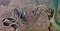 2 Satellite view of mouth (and Missouri)
 -
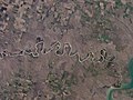 3 Satellite view of White River and mouth
 -
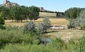 4 White River in Nebraska first view
 -
 5 White River in Nebraska second view


My preference is either #2 or #4. Ruhrfisch ><>°° 02:22, 23 March 2011 (UTC)