Winkel, North Holland
Winkel | |
|---|---|
Village | |
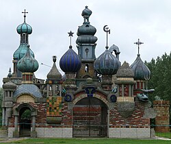
 The Kremlin of Winkel | |
| Coordinates: 52°45′7″N 4°54′13″E / 52.75194°N 4.90361°E | |
| Country | Netherlands |
| Province | North Holland |
| Municipality | Hollands Kroon |
| Area | |
| • Total | 10.18 km2 (3.93 sq mi) |
| Elevation | −0.3 m (−1.0 ft) |
| Population (2021)[1] | |
| • Total | 3,400 |
| • Density | 330/km2 (870/sq mi) |
| Time zone | UTC+1 (CET) |
| • Summer (DST) | UTC+2 (CEST) |
| Postal code | 1731[1] |
| Dialing code | 0224 |
Winkel is a village in the Dutch province of North Holland. It is a part of the municipality of Hollands Kroon, and lies about 11 km north of Heerhugowaard.
History
[edit]The village was first mentioned in 1289 as Winckele, and means "enclosed piece of land".[3] Winkel developed in the Middle Ages as a peat excavation settlement. It was largely destroyed in 1519, and suffered a fire in 1649.[4]
The Dutch Reformed church is an aisleless with needle spire in a neoclassic style. It was built 1845 as a replacement for the medieval church. The tower was rebuilt in 1867.[4] The Kremlin is a garden with follies some of which are over 10 metres (33 ft) tall.[5]
Winkel was home to 660 people in 1840.[5] It was a separate municipality until 1970, when it was merged with Niedorp.[6] In 2012, it became part of the municipality of Hollands Kroon.[5]
Gallery
[edit]-
Former forge
-
Former town hall
-
Dutch Reformed church
References
[edit]- ^ a b c "Kerncijfers wijken en buurten 2021". Central Bureau of Statistics. Retrieved 30 April 2022.
- ^ "Postcodetool for 1731LJ". Actueel Hoogtebestand Nederland (in Dutch). Het Waterschapshuis. Retrieved 30 April 2022.
- ^ "Winkel - (geografische naam)". Etymologiebank (in Dutch). Retrieved 30 April 2022.
- ^ a b Ronald Stenvert & Saskia van Ginkel-Meester (2006). "Winkel" (in Dutch). Zwolle: Waanders. Retrieved 30 April 2022.
- ^ a b c "Winkel". Plaatsengids (in Dutch). Retrieved 30 April 2022.
- ^ Ad van der Meer and Onno Boonstra, Repertorium van Nederlandse gemeenten, KNAW, 2011.


