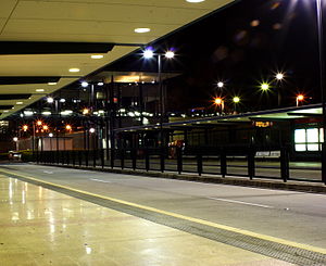
Woolloongabba busway station
Appearance
Woolloongabba | |||||||||||
|---|---|---|---|---|---|---|---|---|---|---|---|
 | |||||||||||
| General information | |||||||||||
| Location | Stanley Street at Ipswich Road, South Brisbane | ||||||||||
| Coordinates | 27°29′10″S 153°02′05.3″E / 27.48611°S 153.034806°E | ||||||||||
| Owned by | TransLink | ||||||||||
| Platforms | 2 | ||||||||||
| Construction | |||||||||||
| Accessible | Yes | ||||||||||
| Other information | |||||||||||
| Fare zone | 2 | ||||||||||
| Services | |||||||||||
| |||||||||||
The Woolloongabba busway station is part of the South East Busway in Brisbane, served by TransLink. It is on a spur from the main trunk route, with inbound services joining the busway proper at Mater Hill. It is adjacent to the Brisbane Cricket Ground, and in Zone 2 of the TransLink integrated public transport system.
Connection to proposed Cross River Rail project
Woolloongabba busway station is proposed to connect to an underground railway station in the Queensland Government's Cross River Rail project.[1][2]
References
- ^ "New Brisbane cross-river rail details released". ABC News. Australian Broadcasting Corporation. 11 November 2010. Retrieved 11 March 2011.
- ^ "Woolloongabba Community Newsletter, July 2010" (PDF). Queensland Government, Urban Land Development Authority. July 2010. Retrieved 11 March 2011.
External links
