Wyszków, Wyszków County
Wyszków | |
|---|---|
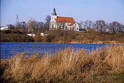
 View with Bug river | |
| Country | |
| Voivodeship | Masovian |
| County | Wyszków County |
| Gmina | Gmina Wyszków |
| Established | 13th century |
| Town rights | 1502 |
| Government | |
| • Mayor | Grzegorz Nowosielski |
| Area | |
| • Total | 20.78 km2 (8.02 sq mi) |
| Population (2006) | |
| • Total | 27,010 |
| • Density | 1,300/km2 (3,400/sq mi) |
| Time zone | UTC+1 (CET) |
| • Summer (DST) | UTC+2 (CEST) |
| Postal code | 07-200, 07-202 |
| Area code | +48 029 |
| Car plates | WWY |
| Website | http://www.wyszkow.pl |
Wyszków [ˈvɨʂkuf] is a town in northeastern Poland with 26,500 inhabitants (2003). It is the capital of Wyszków County (Polish: powiat wyszkowski). Wyszków is situated in the Masovian Voivodeship (since 1999); previously it was in Warsaw Voivodeship (to 1975) and Ostrołęka Voivodeship (1975-1998).
Description
The village of Wyszków was first documented in 1203. The town was founded in 1502. It was destroyed during the Polish-Sweden war in 1655-1660 when it lost its significance in the region. Industry developed from 1897 when the Pilawa-Tluszcz-Ostrołęka railway was built.
Jews in Wyszków
Before World War II half of Wyszków's population of 9,000 were Jewish - after there was none. On 14 September 1997 a memorial to Holocaust victims was unveiled in Wyszków. It is made of reclaimed Jewish gravestones that had been removed from the site in 1939 by German occupiers, who had used them as paving stones and in the construction of the local Gestapo headquarters. Scores of these desecrated tombstones were recovered and incorporated as part of the monument.
Wyszków was the place of birth of Mordechaj Anielewicz in 1919.
Notable people from Wyszków
52°35′36″N 21°27′36″E / 52.59333°N 21.46000°E


