
Zabłudów
Zabłudów | |
|---|---|
 Coat of arms | |
| Country | |
| Voivodeship | Podlaskie |
| County | Białystok |
| Gmina | Zabłudów |
| Area | |
| • Total | 14.3 km2 (5.5 sq mi) |
| Population (2006) | |
| • Total | 2,400 |
| • Density | 170/km2 (430/sq mi) |
| Postal code | 16-060 |
| Website | http://um-zabludow.pbip.pl |
Zabłudów [zaˈbwuduf] (Belarusian: Заблудаў, Zabłudaŭ) is a town in Białystok County, Podlaskie Voivodeship, in north-eastern Poland. Prior to 1999 it was part of the Białystok Voivodeship (1975–1998).
History of Zabłudów

The town of Zabłudów was home to a thriving Jewish community for hundreds of years. It was once the location of the notable Zabłudów Synagogue, a Wooden synagogue of a type unique to the Polish–Lithuanian Commonwealth, built in 1637. A replica of the Zabłudów synagogue was made in 2004 at the University of Wisconsin in the course study.[1]
In July 1941 during the German occupation of Poland, the Nazis created a ghetto for some 1,800 Polish Jews from the vicinity. On 2 November 1942, the ghetto was liquidated and approximately 1,400 Jews were transported by Holocaust trains to the 10th Cavalry camp near Białystok and from there to the Treblinka extermination camp. Almost all were killed that very same day.[2]
Points of interest
-
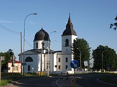 Eastern Orthodox Church of Virgin Mary built between 1847-1855 at the main square
 -
 Classicist Church of Saints Peter and Paul at the square built in 1805-1840


References
- ^ "Zabludow Synagogue Project." Handshouse Studio. University of Wisconsin at Milwaukee.
- ^ "The Deportation of the Zabludow Jews to Treblinka Death Camp." 2003 Tilford Bartman, Jerusalem.
53°01′N 23°21′E / 53.017°N 23.350°E
.svg)
| International | |
|---|---|
| National | |
| Other | |
This Podlaskie Voivodeship location article is a stub. You can help Wikipedia by expanding it. |