Zawoja
Zawoja | |
|---|---|
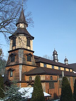
 Catholic church | |
| Coordinates: 49°40′N 19°34′E / 49.667°N 19.567°E | |
| Country | |
| Voivodeship | Lesser Poland |
| County | Sucha County |
| Gmina | Gmina Zawoja |
| Time zone | UTC+1 (CET) |
| • Summer (DST) | UTC+2 (CEST) |
| Postal code | 34-222, 34-223 |
| Area code | +48 33 |
| Car plates | KSU |
| Website | http://www.zawoja.pl |
Zawoja [zaˈvɔja] is a village in Southern Poland located close to Maków Podhalański. It is situated in Sucha County (Lesser Poland Voivodeship). With neighbouring village of Skawica it constitutes a rural Zawoja Commune. It has 6,200 inhabitants (2001) and is often mentioned as one of the biggest Polish villages. It is also very often referred as the longest one as it stretches for about 20 kilometres in a picturesque mountain valley. It lies approximately 9 kilometres (6 mi) south of Sucha Beskidzka and 52 km (32 mi) south-west of the regional capital Kraków.
It is situated close to a mountain massif of Babia Góra (1725 m). The headquarters of Babia Góra National Park is located here. Since 19th century Zawoja is one of the important mountain resorts in Poland. It is known for its wooden architecture and folk culture of Babia Góra highlanders.
See also
- LOT Polish Airlines Flight LO 165 crashed on the nearby Polica mountain
External links
![]() Media related to Zawoja at Wikimedia Commons
Media related to Zawoja at Wikimedia Commons
![]() Zawoja travel guide from Wikivoyage
Zawoja travel guide from Wikivoyage
- Template:Pl icon Zawoja official web site
- Jewish Community in Zawoja on Virtual Shtetl


