Donnington, Herefordshire
Appearance
| Donnington | |
|---|---|
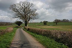
 Road through Donnington | |
Location within Herefordshire | |
| OS grid reference | SO708342 |
| Unitary authority | |
| Ceremonial county | |
| Region | |
| Country | England |
| Sovereign state | United Kingdom |
| Post town | LEDBURY |
| Postcode district | HR8 |
| Dialling code | 01531 |
| Police | West Mercia |
| Fire | Hereford and Worcester |
| Ambulance | West Midlands |
| UK Parliament | |
Donnington is a village and civil parish near Ledbury.
Parish church
[edit]The parish church is dedicated to Saint Mary.[1] Donnington Hall is located here on the outskirts of the village.
In 1870–72, Donnington was described as:
- "DONNINGTON, a parish in Ledbury district, Hereford; under the Malvern hills, at the boundary with Gloucester, 2¼ miles S of Ledbury town and r[ailway]. station. Post town, Ledbury. Acres, 808. Real property, £1, 566. Pop[ulation]., 105. Houses, 20. The property is divided among a few. The living is a rectory in the diocese of Hereford. Value, £209.* Patron, R. Webb, Esq. The church is old but good; and has a wooden tower."[2]
References
[edit]- ^ St Mary, Donnington - a church near you
- ^ Wilson, John Marius (1870). Imperial Gazetteer of England and Wales. Edinburgh: A. Fullerton & Co. Retrieved 27 January 2015.
External links
[edit]![]() Media related to Donnington, Herefordshire at Wikimedia Commons
Media related to Donnington, Herefordshire at Wikimedia Commons

