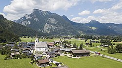
St. Martin bei Lofer
Appearance
St. Martin bei Lofer | |
|---|---|
 | |
| Coordinates: 47°34′00″N 12°42′00″E / 47.56667°N 12.70000°E | |
| Country | Austria |
| State | Salzburg |
| District | Zell am See |
| Government | |
| • Mayor | Josef Leitinger (ÖVP) |
| Area | |
• Total | 63.55 km2 (24.54 sq mi) |
| Elevation | 633 m (2,077 ft) |
| Population (2018-01-01)[2] | |
• Total | 1,153 |
| • Density | 18/km2 (47/sq mi) |
| Time zone | UTC+1 (CET) |
| • Summer (DST) | UTC+2 (CEST) |
| Postal code | 5092 |
| Area code | 06588 |
| Vehicle registration | ZE |
| Website | www.stmartin.at |
St. Martin bei Lofer is a municipality in the district of Zell am See (Pinzgau region), in the state of Salzburg in Austria.
Geography
[edit]The municipality lies in the Loferer Land in the Pinzgauer Saalach valley.
Lamprechtsofen (deepest cave in the nation) is located near the village Obsthurn.
References
[edit]- ^ "Dauersiedlungsraum der Gemeinden Politischen Bezirke und Bundesländer - Gebietsstand 1.1.2018". Statistics Austria. Retrieved 10 March 2019.
- ^ "Einwohnerzahl 1.1.2018 nach Gemeinden mit Status, Gebietsstand 1.1.2018". Statistics Austria. Retrieved 9 March 2019.
External links
[edit]


