Zestafe
Appearance
Zestafe | |
|---|---|
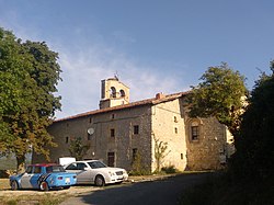
 Church of Zestafe | |
| Coordinates: 42°58′16″N 2°42′18″W / 42.971°N 2.705°W | |
| Country | Spain |
| Autonomous community | Basque Country |
| Province | Álava |
| Comarca | Gorbeialdea |
| Municipality | Zigoitia |
| Area | |
• Total | 1.80 km2 (0.69 sq mi) |
| Elevation | 641 m (2,103 ft) |
| Population (2022)[1] | |
• Total | 38 |
| • Density | 21/km2 (55/sq mi) |
| Postal code | 01138 |
Zestafe (Spanish: Cestafe) is a hamlet and concejo in the municipality of Zigoitia, in Álava province, Basque Country, Spain. Part of the neighborhood of Gorostiza belongs to Zestafe, while the rest of it is part of nearby Acosta.[2]
References
[edit]- ^ "Nomenclátor: Núcleos". Entidades Locales de Álava (in Spanish). Diputación Foral de Álava. 1 January 2022. Retrieved 29 November 2023.
- ^ "Nuestros Pueblos". Ayuntamiento de Zigoitia (in Spanish). Retrieved 29 November 2023.
External links
[edit] Media related to Zestafe at Wikimedia Commons


