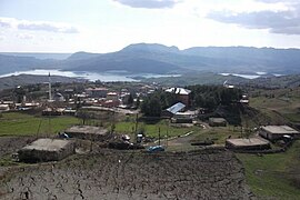
Gerger
Gerger | |
|---|---|
 Gerger | |
| Coordinates: 38°01′44″N 39°01′56″E / 38.02889°N 39.03222°E | |
| Country | Turkey |
| Province | Adıyaman |
| District | Gerger |
| Government | |
| • Mayor | Erkan Aksoy[1] (AKP) |
| Population (2021)[2] | 2,753 |
| Time zone | UTC+3 (TRT) |
| Postal code | 02700 |
| Website | www |
Gerger (Armenian: Գարգար, romanized: Gargar, lit. 'mound'; Kurdish: Aldûş)[3] is a town of Adıyaman Province of Turkey. It is the seat of Gerger District.[4] It is mainly populated by Kurds of different tribal backgrounds and had a population of 2,753 in 2021.[2][5] The mayor is Erkan Aksoy (AKP).[1]
History
[edit]Medieval History
[edit]In the 11th century the town formed a defensive outpost for the Byzantine Empire together with the city of Edessa, Samosata, Ḥiṣn Manṣūr and Chasanara and seems to have had a considerable garrison.[6] After the Byzantines ruler over the region faded, the region around the Mor Bar Sauma monastery and Gerger became a base of power for local chiefs of Syrian and Armenian origin, and the town was under control of Constantine of Gerger.[7]
Modern History
[edit]According to The Geographical Journal in 1896, Gerger had 750 inhabitants with most being Kurds, with the exception of few Ottoman officials and Armenians.[8]
Archaeology
[edit]In 2018, archaeologists discovered a cave which used during religious ceremonies by Christians during the Byzantine period. Cross figures found inside the cave.[9]
References
[edit]- ^ a b "Belediye Sitesi". gerger.bel.tr (in Turkish). August 4, 2020. Retrieved February 9, 2022.
- ^ a b "Address-based population registration system (ADNKS) results dated 31 December 2021" (XLS) (in Turkish). TÜİK. Retrieved 12 January 2023.
- ^ Avcıkıran, Adem (2009). Kürtçe Anamnez Anamneza bi Kurmancî (in Turkish and Kurdish). p. 56.
- ^ İlçe Belediyesi, Turkey Civil Administration Departments Inventory. Retrieved 12 January 2023.
- ^ Aybek, Ömer Faruk (1988). Otuzuncu yılında Gerger (Aldüş) (in Turkish). pp. 48–49.
- ^ Beihammer 2017, p. 115.
- ^ Beihammer 2017, p. 293.
- ^ The Geographical Journal. Royal Geographical Society. 1896.
- ^ Roman-era cave found in Adıyaman
Sources
[edit]- Beihammer, Alexander Daniel (2017). Byzantium and the Emergence of Muslim Turkish Anatolia, ca. 1040-1130. Routledge. ISBN 978-1-138-22959-4.

