Pamulang
Appearance
Pamulang | |
|---|---|
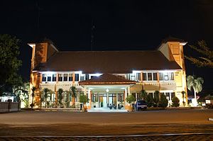
 Pamulang district office in 2013 | |
 Map location of Pamulang | |
| Country | Indonesia |
| Province | Banten |
| City | South Tangerang |
| Established | 11 January 1992 |
| Government | |
| • Camat | Egi Jati Permana, S.E., M.Si. |
| Area | |
| • Total | 28.74 km2 (11.10 sq mi) |
| Population (mid 2023 estimate)[1] | |
| • Total | 324,059 |
| • Density | 11,000/km2 (29,000/sq mi) |
Pamulang is a town and an administrative district (kecamatan) within the city of South Tangerang, in Banten Province on Java, Indonesia. The district covers an area of 28.74 km2 and had a population of 286,270 at the 2010 Census[2] and 305,563 at the 2020 Census;[3] the official estimate as at mid 2023 was 324,059.[1]
History
[edit]Pamulang was previously part of Ciputat district before it was split off from the southern part of the district in 1992.
Communities
[edit]Pamulang District is sub-divided into eight urban communities (kelurahan), listed below with their areas and their officially-estimated populations as at mid 2022,[4] together with their postcodes.
| Kode Wilayah |
Name of kelurahan |
Area in km2 |
Population mid 2022 estimate |
Post code |
|---|---|---|---|---|
| 36.74.06.1001 | Pamulang Barat | 4.16 | 52,930 | 15417 |
| 36.74.06.1002 | Benda Baru | 2.66 | 43,400 | 15418 |
| 36.74.06.1003 | Pondok Benda | 3.86 | 53,074 | 15416 |
| 36.74.06.1004 | Pondok Cabe Udik | 4.83 | 21,353 | 15418 |
| 36.74.06.1005 | Pondok Cabe Ilir | 3.96 | 35,981 | 15418 |
| 36.74.06.1006 | Kedaung | 2.56 | 50,998 | 15415 |
| 36.74.06.1007 | Bambu Apus | 2.20 | 28,757 | 15415 |
| 36.74.06.1008 | Pamulang Timur | 2.59 | 31,274 | 15417 |
| 36.74.06 | Totals | 26.82 | 317,767 (a) |
Notes: (a) comprising 158,749 males and 159,018 females.
References
[edit]
