
Taunton National Park: Difference between revisions
Ksnordstrand (talk | contribs) Undid revision 549951252 by Shiftchange (talk)-sorry I tried to save my current work |
Ksnordstrand (talk | contribs) No edit summary |
||
| Line 1: | Line 1: | ||
{{Unreferenced|date=December 2009}} |
|||
{{Infobox_protected_area_of_Australia |
{{Infobox_protected_area_of_Australia |
||
| name = Taunton National Park |
| name = Taunton National Park |
||
| Line 9: | Line 8: | ||
| nearest_town_or_city = Emerald |
| nearest_town_or_city = Emerald |
||
| coordinates = {{Coord|23|32|0|S|149|13|17|E|type:landmark_region:AU-QLD|display=inline,title}} |
| coordinates = {{Coord|23|32|0|S|149|13|17|E|type:landmark_region:AU-QLD|display=inline,title}} |
||
| area = {{Convert|116|km2|sqmi|1|abbr=on}}<ref name=DERM>{{cite web|last=Department of Environment and Resource Management|title=Taunton National Park (Science): Management Plan 2011|url=http://www.nprsr.qld.gov.au/managing/plans-strategies/pdf/mp057-taunton-np-sci-mgtplan-gic-approved-2011.pdf|work=Department of National Parks, Recreation, Sport and Racing|publisher=Queensland Government|accessdate=4 April 2013}}</ref> |
| area = {{Convert|116|km2|sqmi|1|abbr=on}}<ref name=DERM>{{cite web|last=Department of Environment and Resource Management.|title=Taunton National Park (Science): Management Plan 2011|url=http://www.nprsr.qld.gov.au/managing/plans-strategies/pdf/mp057-taunton-np-sci-mgtplan-gic-approved-2011.pdf|date=2011a|work=Department of National Parks, Recreation, Sport and Racing|publisher=Queensland Government|accessdate=4 April 2013}}</ref> |
||
| established = 1986 |
| established = 1986 |
||
| managing_authorities = [[Queensland Parks and Wildlife Service]] |
| managing_authorities = [[Queensland Parks and Wildlife Service]] |
||
| Line 15: | Line 14: | ||
}} |
}} |
||
'''Taunton National Park''' is situated near [[Dingo]] township, Eastern [[Central Queensland]], [[Australia]], 135 km inland from [[Rockhampton, Queensland|Rockhampton]]. The park is found in the Central Highlands Shire, within the Northern [[Brigalow Belt]] [[Bioregion]] in Queensland, a region widely recognised to contain considerable biodiversity<ref name=DERM /> |
'''Taunton National Park''' is situated near [[Dingo]] township, Eastern [[Central Queensland]], [[Australia]], 135 km inland from [[Rockhampton, Queensland|Rockhampton]]. The park is found in the Central Highlands Shire, within the Northern [[Brigalow Belt]] [[Bioregion]] in Queensland, a region widely recognised to contain considerable biodiversity. <ref name=DERM /> The park encompasses an area of {{convert|11626|ha|abbr=on}}, following an initial land purchase in 1979 and a subsequent addition in 1984.<ref name=DERM /><ref name=wallabydiet1>{{cite journal|authors=Ellis, B. A., Dawson, T. J., & Tierney, P. J.|title=The diet of the bridled nailtail wallaby (Onychogalea fraenata), 1. Site and seasonal influences and dietary overlap with the black-striped wallaby (Macropus dorsalis) and domestic cattle [central Queensland]|journal=Wildlife Research|year=1992|volume=19|pages=65-78}}|url=http://agris.fao.org/agris-search/search/display.do?f=1996/AU/AU96005.xml;AU9204211</ref> |
||
Taunton National Park is designated as a strictly scientific [[nature reserve]] due to its importance in ensuring the ongoing survival and protection of the endangered [[Bridled Nail-tail Wallaby]] (''Onychogalea fraenata'') |
Taunton National Park is designated as a strictly scientific [[nature reserve]] due to its importance in ensuring the ongoing survival and protection of the endangered [[Bridled Nail-tail Wallaby]] (''Onychogalea fraenata'').<ref name=IUCN_BNTW>{{cite web|last=McKnight|first=M|title=''Onychogalea fraenata''. In IUCN 2012: IUCN Red List of Threatened Species. Version 2012.2|url=http://www.iucnredlist.org/details/15330/0|work=IUCN|publisher=IUCN|accessdate=10 April, 2013}}</ref> The parks establishment and ongoing management to protect the wallaby, has facilitated natural [[regeneration]] processes within reserve boundaries, protected [[ecosystem]] communities from further agricultural disturbances in the surrounding landscape, provided [[habitats]] for native [[fauna]] and helped conserve a wide range of [[biodiversity]].<ref name=BrigForest>{{cite journal|authors=Bowen, M. E., McAlpine, C. A., Seabrook, L. M., House, A. P., & Smith, G. C.|title=The age and amount of regrowth forest in fragmented brigalow landscapes are both important for woodland dependent birds.|journal=Biological Conservation|year=2009|volume=142|issue=12|pages=3051-3059|doi=10.1016/j.biocon.2009.08.005}}</ref> |
||
==Region Description== |
==Region Description== |
||
Clay soils dominate the |
Clay soils dominate the tropical savannah of the Northern Brigalow Belt, and the topography ranges from open plains to undulating hills and valleys.<ref name=WWF>{{cite book|last=World Wildlife Fund (Lead Author) & McGinley, M. (EOE Topic Ed.)|title=''Brigalow tropical savanna''|publisher=Environmental Information Coalition, National Council for Science and the Environment|location=Washington, D. C.|url=http://www.eoearth.org/article/Brigalow_tropical_savanna#gen0|editor=Encyclopedia of Earth (C. J. Cleveland, Encyclopedia of Earth Ed.)|accessdate=11 April, 2013|date=7 March, 2007, Revised 1 July, 2012}}</ref> |
||
The regions climate is described as subtropical and semi-arid, with a mean annual rainfall of 711 mm, half of which is concentrated over the Summer months; from December to February |
The regions climate is described as subtropical and semi-arid, with a mean annual rainfall of 711 mm, half of which is concentrated over the Summer months; from December to February.<ref name=Fairywren>{{cite journal|authors=Chan, K., & Augusteyn, J. D.|title=Relationship between bird-unit size and territory quality in three species of fairy-wrens (''Malarus'' spp.) with overlapping territories.|journal=Ecological Research|year=2003|volume=18|issue=1|pages=73-80|doi=10.1046/j.1440-1703.2003.00534.x}}</ref><ref name=VegeStructure>{{cite journal|authors=Fisher, D. O.|title=Effects of vegetation structure, food and shelter on the home range and habitat use of an endangered wallaby.|journal=Journal of Applied Ecology|year=2000|volume=37|issue=4|pages=660-671|doi=10.1046/j.1365-2664.2000.00518.x}}</ref> The distribution of rainfall over such a condensed period leaves the area prone to droughts; exposing the park to an average of one sustained drought event every decade.<ref name=Drought>{{cite journal|authors=Fisher, D. O., Blomberg, S. P., & Hoyle, S. D.|title=Mechanisms of drought-induced population decline in an endangered wallaby.|journal=Biological Conservation|year=2001|volume=102|issue=1|pages=107-115|doi=10.1016/S0006-3207(00)00200-7}}</ref> <ref name=VegeStructure /> The most recent drought of significance occurred between 1991 and 1995 with detrimental impacts on the bridled nailtail wallaby population.<ref name=Drought /> |
||
A combination of open, grassy Eucalypt woodlands |
A combination of open, grassy Eucalypt woodlands, transitional zones and regrowing Acacia shrub-lands and forests comprise Taunton National Parks main vegetation zones.<ref name=wallabydiet1 /> The most common vegetation associations within the park and surrounding areas, tend to be dominated by either Brigalow (''[[Acacia harpophylla]]'') or poplar box (''[[Eucalyptus populnea]]'') species, which commonly occur along with other ''Acacia'' and ''Ecualyptus'' spp.<ref name=wallabydiet1 /><ref name=Bowerdecs /><ref name=Demography>{{cite journal|authors= Pople, A., Lowry, J., Lundie-Jenkins, G., Clancy, T. F., McCallum, H. I., Sigg, D., Hoolihan, D. & Hamilton, S.|title=Demography of bridled nailtail wallabies translocated to the edge of their former range from captive and wild stock|journal=Biological Conservation|year=2001|volume=102|issue=3|page=285-299|doi=10.1016/S0006-3207(01)00101-X}}</ref> Water-bodies present within the park boundaries consist of 15 dams and a small number of creeks.<ref name=Bowerdecs>{{cite journal|last=Madden|first=J. R|title=Bower decorations are good predictors of mating success in the spotted bowerbird|journal=Behavioural Ecology and Sociobiology|year=2003|volume=53|pages=269-277|doi=10.1007/s00265-003-0583-6}}</ref> |
||
[[File:Brigalow tree.jpg|thumbnail|Brigalow Tree - ''A. harpophylla''|left]] |
|||
[[File:Eucalyptus populnea tree.jpg|thumbnail|Poplar Box - ''Eucalyptus populnea''|left]] |
|||
==Regional History== |
==Regional History== |
||
| ⚫ | The region in which Taunton National Park is located, was (and still is) subject to long-term, wide-scale agricultural development and associated disturbances. During the 1950's and 60's extensive clearance of brigalow scrub began to take place in order to establish pastoral grasses for grazing domestic sheep and cattle.<ref name=Diet2>{{cite journal|authors=Dawson, T. J., Tierney, P. J., Ellis, B. A.|title=The diet of the Bridled nailtail wallaby (''Onychogalea fraenata'') II Overlap in dietry niche bredth and plant preferences with the black-striped wallaby (''Macropus dorsalis'') and domestic cattle|journal=Wildlife Research|year=1992|volume=19|issue=1|pages=79-87|doi=10.1071/WR9920079}}</ref><ref name=Rediscovery>{{cite journal|authors=Gordon, G., & Lawrie, B. C.|title=The Rediscovery of the Bridled Nail-Tailed Wallaby, ''Onychogalea fraenata'' (Gould)(Marsupialia: Macropodidae).|journal=Wildlife Research|year=1980|volume=7|issue=3|pages=339-345|doi=10.1071/WR9800339}}</ref> Buffle grass (''[[Cenchrus ciliaris]]'') was widely sowed for fodder in the cleared areas, and rapidly became irreversibly established<ref name=Conservation>{{cite journal|authors=Kearney, F., McAllister, R. R., & MacLeod, N. D.|title=Conservation and grazing in Australia's north-east: the bridled nailtail wallaby.|journal=Pastoralism|year=2012|volume=2|issue=1|pages=1-17|url=http://link.springer.com/article/10.1186/2041-7136-2-20|accessdate=09 April 2013}}</ref> |
||
| ⚫ | A governmental initiative called the 'Brigalow Development Scheme' provided great incentive for increasing agricultural development in the Brigalow region and accelerated the rate and scale of vegetation clearance for conversion to buffle grass.<ref name=Rediscovery /> The success of this scheme resulted in agricultural system adjustments so that more intensive [[land use]] practices became common, with smaller properties and higher stock numbers.<ref name=Rediscovery /> The cumulative effects of this land use change resulted in a considerable reduction in remnant vegetation patch size and occurrence.<ref name=Rediscovery /> This in turn reduced the availability of habitat, food and shelter for native fauna, and altered the natural vegetation composition.<ref name=Rediscovery /><ref name=Conservation /> |
||
| ⚫ | The region in which Taunton National Park is located, was (and still is) subject to long-term, wide-scale agricultural development and associated disturbances. During the 1950's and 60's extensive clearance of |
||
| ⚫ | A governmental initiative called the 'Brigalow Development Scheme' provided great incentive for increasing agricultural development in the Brigalow region and accelerated the rate and scale of vegetation clearance for conversion to |
||
===Park Establishment=== |
|||
[[File:IBRA 6.1 Brigalow Belt North.png|thumb|IBRA 6.1 Brigalow Belt North]] |
|||
In 1973 a Bridled nail-tail wallaby was sighted on a cattle property named 'Taunton' and reported by |
In 1973 a Bridled nail-tail wallaby was sighted on a cattle property named 'Taunton' and reported by a fencing contractor.<ref name=Rediscovery /> There there had been reports of a significant decline in the wallabies population numbers during the early 1900's and there were no recorded sightings since the 1930's, so subsequently the species had been presumed extinct.<ref name=Demography /> <ref name=Rediscovery /> Following this sighting, Taunton was purchased in 1979 and established as a scientific reserve, solely to ensure the protection of the wallaby.<ref name=wallabydiet1 /><ref name=DERM /> Then in 1984, another cattle property 'Red Hill', situated adjacent to Taunton, was added to the reserve and the whole area later became officially named 'Taunton National Park'.<ref name=wallabydiet1 /><ref name=DERM /> |
||
==Biology and Ecology== |
==Biology and Ecology== |
||
The park |
The park is located in the Northern Brigalow 'Tropical Savannah' Ecoregion, which is so named for the predominant flora of the region; Brigalow ''Acacia harpophylla''.<ref name=WWF /> Vegetation clearance throughout this region and in fact the whole Brigalow Belt, has resulted in an extensive loss of biodiversity and overall ecosystem degradation.<ref name=Biodiversity>{{cite journal|authors=McAlpine, C. A., Fensham, R. J., & Temple-Smith, D. E.|title=Biodiversity conservation and vegetation clearing in Queensland: principles and thresholds.|journal=The Rangeland Journal|year=2002|volume=24|issue=1|pages=36-55|doi=10.1071/RJ02002}}</ref> Despite considerable regional agricultural and pastoral development, a large proportion of the park's vegetation remained intact or was exposed to minimal disturbance prior to the reserve being established.<ref name=Diet2 /> Up to around 1975, only 17% of vegetation within the park had been cleared, resulting in the the park providing an important representation of ecosystems and vegetation communities that were regionally prevalent, with many of these communities now restricted to bush fragments and reserves.<ref name=wallabydiet1 /><ref name=WWF /><ref name=DERM /> |
||
The region that the park is located in has been classified as having the highest rate of annual clearance in comparison with other subregions within Queensland.<ref name=Extent>{{cite journal|authors=Wilson, B. A., Neldner, V. J., & Accad, A.|title=The extent and status of remnant vegetation in Queensland and its implications for statewide vegetation and legislation.|journal=The Rangeland Journal|year=2002|volume=24|issue=1|pages=6-35|doi=10.1071/RJ02001}}</ref> This high clearance rate has contributed to a number of Brigalow-typical ecosystems becoming otherwise at risk or endangered, highlighting the significance of the parks contribution to regional biodiversity conservation, with several of these communities being represented within the reserve.<ref name=wallabydiet1 /><ref name=DERM /> More specifically, ''A. harpophylla'' vegetation associations with belah (''[[Casuarina cristata]]'') or dawson gum (''[[Eucalyptus cambageana]]'') or wilga (''[[Geijera parviflora]]'') and false sandalwood (''[[Eremophila]]'') as open forest/woodland, are classified as endangered.<ref name=DERM /> Brigalow shrubland/forest, in association with yellow wood and false sandalwood, have undergone wide-scale clearing, as previously mentioned, and has also been classified as an endangered.<ref name=DERM /> Communities represented within the park which are considered to be 'of concern' include those poplar box (''E. populnea'') open, grassy woodlands and ''Eucalyptus spp.'' with or without ''Corymbia spp.'' in grass or scrubby woodlands.<ref name=DERM />.<ref name=Extent /> |
|||
===Flora=== |
===Flora=== |
||
===Fauna=== |
===Fauna=== |
||
[[File:Golden Tailed Gecko.jpg|thumb|Golden Tailed Gecko]] |
|||
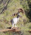
The protection of Taunton National Park has provided an important refuge and habitat for a wide range of biodiversity including various [[macropod]] species (kangaroos and wallabies etc.) and other mammals, over 70 species of bird and numerous reptiles and snakes.<ref name=DERM /> Notable bird species known to inhabit the reserve include the [[vulnerable]] Southern sub-species of [[squatter pigeon]] (''Geophaps scripta scripta'') and the migratory [rainbow bee-eater]] (''Merops ornatus''), which is protected under various international migratory bird agreements.<ref name=DERM /> Reptile species of significance inhabiting the reserve include the vulnerable [[brigalow scaly-foot]] lizard (Paradelma orientalis,) and the [[arboreal]] golden-tailed gecko (Strophurus taenicauda) (NPRS) which is classified as [[near threatened]].<ref name=DERM /> In addition to the bridled nailtail wallaby, a number of [[macropods]] have a [[distribution range]] which extends through the reserve.<ref name=Parasites>{{cite journal|authors=Turni, C., & Smales, L. R.|title=Parasites of the bridled nailtail wallaby (''Onychogalea fraenata'')(Marsupialia: Macropodidae).|journal=Wildlife Research|year=2001|volume=28|issue=4|pages=403-411|doi=10.1071/WR99108}}</ref> These can include the [[black-striped wallaby]] (''Macropus dorsalis''), the [[eastern grey kangaroo]] (''Macropus giganteus'') and the [[swamp wallaby]] (''wallabia bicolour'').<ref name=Parasites /> |
|||
Research is regularly conducted, under permit, at the park concentrating on more species than just the bridled nailtail wallaby, with population monitoring and manipulation of factors such as habitat and food resources.<ref name=DERM /> Populations of variegated, superb and red-backed fairy-wren species ([[''Malurus lamberti'']], [[''Malurus cyaneus'']] & [[''Malarus melanocephalus'']]) and the spotted bower bird ([[''Chlamydera maculata'']]) which inhabit the reserve, have been the subjects of considerable scientific research, including focuses on territory, behaviour, diet, habitat preferences and mating.<ref name=Bowerdecs /><ref name=Fairywren /><ref name=BowerLocation>{{cite journal|authors=Miles, A. J., & Madden, J. R.|title=Bower location by the spotted bowerbird (''Chlamydera maculata'')|journal=Emu|year=2002|volume=10|issue=2|pages=187-193|doi=10.1071/MU00039}}</ref><ref name=BowerTraditions>{{cite journal|authors=Madden, J. R., Lowe, T. J., Fuller, H. V., Dasmahapatra, K. K., & Coe, R. L.|title=Local traditions of bower decoration by spotted bowerbirds in a single population.|journal=Animal Behaviour|year=2004|volume=68|issue=4|pages=759-765|doi=10.1016/j.anbehav.2003.12.007}}</ref> |
|||
<gallery> |
|||
File:Merops ornatus -Australia-8.jpg|Merops ornatus |
|||
File:Squatter Pigeons Cement Mills.JPG|Squatter Pigeons |
|||
File:Eastern Grey Kangaroo.jpg|Eastern Grey Kangaroo |
|||
File:Macropus robustus white - Christopher Watson.jpg|Macropus robustus |
|||
File:Image-Swamp-Wallaby-Feeding-5,-Vic,-Jan.2008.jpg|Swamp Wallaby |
|||
</gallery> |
|||
=====Bridled Nail-tail Wallaby===== |
=====Bridled Nail-tail Wallaby===== |
||
| ⚫ | |||
==Values== |
==Values== |
||
===Conservation=== |
===Conservation=== |
||
| Line 48: | Line 67: | ||
===Cultural=== |
===Cultural=== |
||
===Scientific Research=== |
|||
==Management== |
==Management== |
||
| ⚫ | |||
===Threats=== |
===Threats=== |
||
Revision as of 05:42, 13 April 2013
| Taunton National Park Error: |state= not defined (help) | |
|---|---|
 Taunton National Park | |
| Coordinates | 23°32′0″S 149°13′17″E / 23.53333°S 149.22139°E |
| Established | 1986 |
| Area | 116 km2 (44.8 sq mi)[1] |
Error: |type= not defined (help) | |
Taunton National Park is situated near Dingo township, Eastern Central Queensland, Australia, 135 km inland from Rockhampton. The park is found in the Central Highlands Shire, within the Northern Brigalow Belt Bioregion in Queensland, a region widely recognised to contain considerable biodiversity. [1] The park encompasses an area of 11,626 ha (28,730 acres), following an initial land purchase in 1979 and a subsequent addition in 1984.[1][2]
Taunton National Park is designated as a strictly scientific nature reserve due to its importance in ensuring the ongoing survival and protection of the endangered Bridled Nail-tail Wallaby (Onychogalea fraenata).[3] The parks establishment and ongoing management to protect the wallaby, has facilitated natural regeneration processes within reserve boundaries, protected ecosystem communities from further agricultural disturbances in the surrounding landscape, provided habitats for native fauna and helped conserve a wide range of biodiversity.[4]
Region Description
Clay soils dominate the tropical savannah of the Northern Brigalow Belt, and the topography ranges from open plains to undulating hills and valleys.[5] The regions climate is described as subtropical and semi-arid, with a mean annual rainfall of 711 mm, half of which is concentrated over the Summer months; from December to February.[6][7] The distribution of rainfall over such a condensed period leaves the area prone to droughts; exposing the park to an average of one sustained drought event every decade.[8] [7] The most recent drought of significance occurred between 1991 and 1995 with detrimental impacts on the bridled nailtail wallaby population.[8]
A combination of open, grassy Eucalypt woodlands, transitional zones and regrowing Acacia shrub-lands and forests comprise Taunton National Parks main vegetation zones.[2] The most common vegetation associations within the park and surrounding areas, tend to be dominated by either Brigalow (Acacia harpophylla) or poplar box (Eucalyptus populnea) species, which commonly occur along with other Acacia and Ecualyptus spp.[2][9][10] Water-bodies present within the park boundaries consist of 15 dams and a small number of creeks.[9]


Regional History
The region in which Taunton National Park is located, was (and still is) subject to long-term, wide-scale agricultural development and associated disturbances. During the 1950's and 60's extensive clearance of brigalow scrub began to take place in order to establish pastoral grasses for grazing domestic sheep and cattle.[11][12] Buffle grass (Cenchrus ciliaris) was widely sowed for fodder in the cleared areas, and rapidly became irreversibly established[13]
A governmental initiative called the 'Brigalow Development Scheme' provided great incentive for increasing agricultural development in the Brigalow region and accelerated the rate and scale of vegetation clearance for conversion to buffle grass.[12] The success of this scheme resulted in agricultural system adjustments so that more intensive land use practices became common, with smaller properties and higher stock numbers.[12] The cumulative effects of this land use change resulted in a considerable reduction in remnant vegetation patch size and occurrence.[12] This in turn reduced the availability of habitat, food and shelter for native fauna, and altered the natural vegetation composition.[12][13]
Park Establishment

In 1973 a Bridled nail-tail wallaby was sighted on a cattle property named 'Taunton' and reported by a fencing contractor.[12] There there had been reports of a significant decline in the wallabies population numbers during the early 1900's and there were no recorded sightings since the 1930's, so subsequently the species had been presumed extinct.[10] [12] Following this sighting, Taunton was purchased in 1979 and established as a scientific reserve, solely to ensure the protection of the wallaby.[2][1] Then in 1984, another cattle property 'Red Hill', situated adjacent to Taunton, was added to the reserve and the whole area later became officially named 'Taunton National Park'.[2][1]
Biology and Ecology
The park is located in the Northern Brigalow 'Tropical Savannah' Ecoregion, which is so named for the predominant flora of the region; Brigalow Acacia harpophylla.[5] Vegetation clearance throughout this region and in fact the whole Brigalow Belt, has resulted in an extensive loss of biodiversity and overall ecosystem degradation.[14] Despite considerable regional agricultural and pastoral development, a large proportion of the park's vegetation remained intact or was exposed to minimal disturbance prior to the reserve being established.[11] Up to around 1975, only 17% of vegetation within the park had been cleared, resulting in the the park providing an important representation of ecosystems and vegetation communities that were regionally prevalent, with many of these communities now restricted to bush fragments and reserves.[2][5][1]
The region that the park is located in has been classified as having the highest rate of annual clearance in comparison with other subregions within Queensland.[15] This high clearance rate has contributed to a number of Brigalow-typical ecosystems becoming otherwise at risk or endangered, highlighting the significance of the parks contribution to regional biodiversity conservation, with several of these communities being represented within the reserve.[2][1] More specifically, A. harpophylla vegetation associations with belah (Casuarina cristata) or dawson gum (Eucalyptus cambageana) or wilga (Geijera parviflora) and false sandalwood (Eremophila) as open forest/woodland, are classified as endangered.[1] Brigalow shrubland/forest, in association with yellow wood and false sandalwood, have undergone wide-scale clearing, as previously mentioned, and has also been classified as an endangered.[1] Communities represented within the park which are considered to be 'of concern' include those poplar box (E. populnea) open, grassy woodlands and Eucalyptus spp. with or without Corymbia spp. in grass or scrubby woodlands.[1].[15]
Flora
Fauna

The protection of Taunton National Park has provided an important refuge and habitat for a wide range of biodiversity including various macropod species (kangaroos and wallabies etc.) and other mammals, over 70 species of bird and numerous reptiles and snakes.[1] Notable bird species known to inhabit the reserve include the vulnerable Southern sub-species of squatter pigeon (Geophaps scripta scripta) and the migratory [rainbow bee-eater]] (Merops ornatus), which is protected under various international migratory bird agreements.[1] Reptile species of significance inhabiting the reserve include the vulnerable brigalow scaly-foot lizard (Paradelma orientalis,) and the arboreal golden-tailed gecko (Strophurus taenicauda) (NPRS) which is classified as near threatened.[1] In addition to the bridled nailtail wallaby, a number of macropods have a distribution range which extends through the reserve.[16] These can include the black-striped wallaby (Macropus dorsalis), the eastern grey kangaroo (Macropus giganteus) and the swamp wallaby (wallabia bicolour).[16]
Research is regularly conducted, under permit, at the park concentrating on more species than just the bridled nailtail wallaby, with population monitoring and manipulation of factors such as habitat and food resources.[1] Populations of variegated, superb and red-backed fairy-wren species (''Malurus lamberti'', ''Malurus cyaneus'' & ''Malarus melanocephalus'') and the spotted bower bird (''Chlamydera maculata'') which inhabit the reserve, have been the subjects of considerable scientific research, including focuses on territory, behaviour, diet, habitat preferences and mating.[9][6][17][18]
-
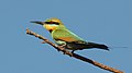 Merops ornatus
 -
 Squatter Pigeons
 -
 Eastern Grey Kangaroo
 -
 Macropus robustus
 -
 Swamp Wallaby


Bridled Nail-tail Wallaby
Values
Conservation
Cultural
Management
Threats
Objectives
See also
References
- ^ a b c d e f g h i j k l m n Department of Environment and Resource Management. (2011a). "Taunton National Park (Science): Management Plan 2011" (PDF). Department of National Parks, Recreation, Sport and Racing. Queensland Government. Retrieved 4 April 2013.
- ^ a b c d e f g "The diet of the bridled nailtail wallaby (Onychogalea fraenata), 1. Site and seasonal influences and dietary overlap with the black-striped wallaby (Macropus dorsalis) and domestic cattle [central Queensland]". Wildlife Research. 19: 65–78. 1992.
{{cite journal}}: Cite uses deprecated parameter|authors=(help)|url=http://agris.fao.org/agris-search/search/display.do?f=1996/AU/AU96005.xml;AU9204211 - ^ McKnight, M. "Onychogalea fraenata. In IUCN 2012: IUCN Red List of Threatened Species. Version 2012.2". IUCN. IUCN. Retrieved 10 April, 2013.
{{cite web}}: Check date values in:|accessdate=(help) - ^ "The age and amount of regrowth forest in fragmented brigalow landscapes are both important for woodland dependent birds". Biological Conservation. 142 (12): 3051–3059. 2009. doi:10.1016/j.biocon.2009.08.005.
{{cite journal}}: Cite uses deprecated parameter|authors=(help) - ^ a b c World Wildlife Fund (Lead Author) & McGinley, M. (EOE Topic Ed.) (7 March, 2007, Revised 1 July, 2012). Encyclopedia of Earth (C. J. Cleveland, Encyclopedia of Earth Ed.) (ed.). Brigalow tropical savanna. Washington, D. C.: Environmental Information Coalition, National Council for Science and the Environment. Retrieved 11 April, 2013.
{{cite book}}:|last=has generic name (help); Check date values in:|accessdate=and|date=(help) - ^ a b "Relationship between bird-unit size and territory quality in three species of fairy-wrens (Malarus spp.) with overlapping territories". Ecological Research. 18 (1): 73–80. 2003. doi:10.1046/j.1440-1703.2003.00534.x.
{{cite journal}}: Cite uses deprecated parameter|authors=(help) - ^ a b "Effects of vegetation structure, food and shelter on the home range and habitat use of an endangered wallaby". Journal of Applied Ecology. 37 (4): 660–671. 2000. doi:10.1046/j.1365-2664.2000.00518.x.
{{cite journal}}: Cite uses deprecated parameter|authors=(help) - ^ a b "Mechanisms of drought-induced population decline in an endangered wallaby". Biological Conservation. 102 (1): 107–115. 2001. doi:10.1016/S0006-3207(00)00200-7.
{{cite journal}}: Cite uses deprecated parameter|authors=(help) - ^ a b c Madden, J. R (2003). "Bower decorations are good predictors of mating success in the spotted bowerbird". Behavioural Ecology and Sociobiology. 53: 269–277. doi:10.1007/s00265-003-0583-6.
- ^ a b "Demography of bridled nailtail wallabies translocated to the edge of their former range from captive and wild stock". Biological Conservation. 102 (3): 285-299. 2001. doi:10.1016/S0006-3207(01)00101-X.
{{cite journal}}: Cite uses deprecated parameter|authors=(help) - ^ a b "The diet of the Bridled nailtail wallaby (Onychogalea fraenata) II Overlap in dietry niche bredth and plant preferences with the black-striped wallaby (Macropus dorsalis) and domestic cattle". Wildlife Research. 19 (1): 79–87. 1992. doi:10.1071/WR9920079.
{{cite journal}}: Cite uses deprecated parameter|authors=(help) - ^ a b c d e f g "The Rediscovery of the Bridled Nail-Tailed Wallaby, Onychogalea fraenata (Gould)(Marsupialia: Macropodidae)". Wildlife Research. 7 (3): 339–345. 1980. doi:10.1071/WR9800339.
{{cite journal}}: Cite uses deprecated parameter|authors=(help) - ^ a b "Conservation and grazing in Australia's north-east: the bridled nailtail wallaby". Pastoralism. 2 (1): 1–17. 2012. Retrieved 09 April 2013.
{{cite journal}}: Check date values in:|accessdate=(help); Cite uses deprecated parameter|authors=(help) - ^ "Biodiversity conservation and vegetation clearing in Queensland: principles and thresholds". The Rangeland Journal. 24 (1): 36–55. 2002. doi:10.1071/RJ02002.
{{cite journal}}: Cite uses deprecated parameter|authors=(help) - ^ a b "The extent and status of remnant vegetation in Queensland and its implications for statewide vegetation and legislation". The Rangeland Journal. 24 (1): 6–35. 2002. doi:10.1071/RJ02001.
{{cite journal}}: Cite uses deprecated parameter|authors=(help) - ^ a b "Parasites of the bridled nailtail wallaby (Onychogalea fraenata)(Marsupialia: Macropodidae)". Wildlife Research. 28 (4): 403–411. 2001. doi:10.1071/WR99108.
{{cite journal}}: Cite uses deprecated parameter|authors=(help) - ^ "Bower location by the spotted bowerbird (Chlamydera maculata)". Emu. 10 (2): 187–193. 2002. doi:10.1071/MU00039.
{{cite journal}}: Cite uses deprecated parameter|authors=(help) - ^ "Local traditions of bower decoration by spotted bowerbirds in a single population". Animal Behaviour. 68 (4): 759–765. 2004. doi:10.1016/j.anbehav.2003.12.007.
{{cite journal}}: Cite uses deprecated parameter|authors=(help)
This Queensland protected areas related article is a stub. You can help Wikipedia by expanding it. |