
Altostratus cloud
| Altostratus cloud | |
|---|---|
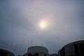
 Altostratus over Hong Kong, China on May 13, 2012. | |
| Abbreviation | As |
| Symbol | |
| Genus | Alto- (Middle) -stratus (layered) |
| Altitude | 2,400–6,100 m (6,500–20,000 ft) |
| Appearance | Sheet or layer, can usually see the sun through it |
| Precipitation | Rain possible in thickened clouds. Classification is changed to nimbostratus if rain becomes persistent.[2] |
Altostratus is a cloud belonging to a class characterized by a generally uniform gray to bluish-gray[3] sheet or layer, lighter in color than nimbostratus and darker than cirrostratus. The sun can be seen through thin altostratus, but thicker layers can be quite opaque. They can look similar to lower altitude stratus clouds.

Altostratus clouds are formed by the rising of a large air mass that condenses into a cloud. They can produce light precipitation, often in the form of virga. If the precipitation increases in persistence and intensity, the altostratus cloud may thicken into nimbostratus.[2]
Altostratus most often takes the form of a featureless sheet of cloud but can be wavy (undulatus) as a result of wind shear through the cloud. It can also be fragmented (fibratus) with clear sky visible, which often signals the approach of a weakened or upper level warm front.
Description
Altostratus clouds may be composed of either water droplets or ice crystals. In some ice crystal altostratus, very thin, rapidly-disappearing horizontal sheets of water droplets appear at random.[4] The sizes of the ice crystals in the cloud tended to increase as altitude decreased. However, close to the bottom of the cloud, the particles decreased in size again. During the sampling of one cloud, the scientists noted a halo while flying near the top of the cloud, which indicated that the ice crystals were hexagonal near the top. However, farther down, the ice crystals became more conglomerated.[5][6]
Formation
Altostratus is caused by a large air mass that is lifted then condensed, usually by an incoming frontal system, and they can be found over widespread areas. Their altitude is from 2,400–6,100 metres (6,500–20,000 feet). They are primarily composed of water droplets.[1] They can rise at velocities up to .05 to .1 metres per second (.16 to .33 feet per second).[7] They can also be the result of the thickening of a cirrostratus cloud.[8] Altostratus is rarely seen alone in the sky, as there is usually some accompanying stratocumulus or stratus fractus underneath it, this being due to the increased moisture beneath the altostratus or cumulus clouds dying as the altostratus reduces surface heating by the sun.
Gallery
-
 Altostratus undulatus at sunrise
 -
 Altostratus opacus at the edge of a warm front
 -
 Altostratus translucidus with stratocumulus below
 -
 Altostratus translucidus


Sources
- Footnotes
- ^ a b Palmer, Chad (16 October 2005). "Stratus Clouds". Weather. USA Today. Retrieved 20 April 2011.
- ^ a b "The cloud classification system - Altostratus". Retrieved 26 May 2009.
- ^ "Alto Clouds". Web Weather for Kids. University Corporation for Atmospheric Research. Retrieved 20 April 2011.
- ^ Platt 1977, p. 344
- ^ Field 1999, p. 1929
- ^ Field 1999, p. 1933
- ^ IUPAC 1997
- ^ "Common Cloud Names, Shapes, and Altitudes" (PDF). Georgia Tech. p. 8. Retrieved 10 July 2011.
- Bibliography
- Field, Paul R. (1998). "Aircraft Observations of Ice Crystal Evolution in an Altostratus Cloud". Journal of Applied Meteorology. 56. American Meteorological Society: 1925 1941. Bibcode:1999JAtS...56.1925F. doi:10.1175/1520-0469(1999)056<1925:AOOICE>2.0.CO;2. ISSN 1520-0469. Retrieved 20 April 2011.
{{cite journal}}: Unknown parameter|month=ignored (help) - "Altostratus Cloud (in Atmospheric Chemistry)". IUPAC Compendium of Chemical Terminology (PDF) (2 ed.). International Union of Pure and Applied Chemistry (IUPAC). 1997. Retrieved 20 April 2011.
- Platt, C. M. R. (1977). "Lidar Observation of a Mixed-Phase Altostratus Cloud". Journal of Applied Meteorology. 16 (4). American Meteorological Society: 339 345. Bibcode:1977JApMe..16..339P. doi:10.1175/1520-0450(1977)016<0339:LOOAMP>2.0.CO;2. ISSN 0021-8952. Retrieved 20 April 2011.
{{cite journal}}: Unknown parameter|month=ignored (help)