Amasia District
Amasia District
Ամասիայի շրջան | |
|---|---|
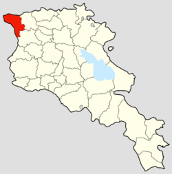
 The Amasia District in Armenia | |
| Country | |
| Established | 9 September 1930 |
| Abolished | 11 April 1995 |
| Capital | Amasia |
| Area | |
| • Total | 534 km2 (206 sq mi) |
| Population (1989) | |
| • Total | 6,342 |
| • Density | 12/km2 (31/sq mi) |
The Amasia District (Armenian: Ամասիայի շրջան) was a raion (district) of the Armenian Soviet Socialist Republic from 1930 and later in 1991 of the Republic of Armenia until its disestablishment in 1995. The Amasia District today constitutes a northwestern part of the Shirak Province (marz) and bordered the Kars Province of the Republic of Turkey to the west, and the Javakheti region of Georgia to the north. Its administrative center was the town Amasia.
History
The Amasia District was formed on the territory of the Armenian SSR in 1930, originally part of the Leninakan uezd (previously Alexandropol uezd).[1] Amasia is the only territory of the former Kars Oblast retained by Armenia as the rest of it was annexed by Turkey through the Treaty of Kars.[2]
The district and its capital were originally known as Aghbaba (Armenian: Աղբաբա) before being renamed Amasia in the 1930s.[3]
Shortly after the Dissolution of the Soviet Union, the Republic of Armenia consolidated the Amasia, Ani, Artik, Akhuryan, and Ashotsk districts into the larger Shirak Province.[4]
Demographics
| Year | Armenians | Azerbaijanis[a] | Others | TOTAL | |||
|---|---|---|---|---|---|---|---|
| 1831 | 1,420 | 29.2% | 3,451 | 70.8% | 4,871 | ||
| 1873 | 8,700 | 100.0% | 8,700 | ||||
| 1886 | 11,230 | 100.0% | 11,230 | ||||
| 1897 | 13,497 | 56.0% | 10,359 | 43.0% | 262 | 1.1% | 24,118 |
| 1908 | 28,374 | ||||||
| 1914[b] | 34,517 | ||||||
| 1914[c] | 32,361 | ||||||
| 1916 | 33,199 | ||||||
| 1919 | 33,318 | ||||||
| 1922 | 11,873 | 65.8% | 6,131 | 34.0% | 27 | 0.1% | 18,031 |
| 1926 | 13,664 | 62.9% | 31 | 0.1% | 8,034[d] | 37.0% | 21,729 |
| 1931 | 19,084 | 67.8% | 7,889 | 28.0% | 1,160 | 4.1% | 28,133 |
| 1939[6] | 4,466 | 30.0% | 10,140 | 68.0% | 305 | 2.0% | 14,911 |
| 1959[7] | 9,431[8] | 71.9% | 12,794 | ||||
| 1970[9] | 15,002[8] | 80.9% | 18,547 | ||||
| 1979[10] | 17,109[8] | 81.5% | 20,581 | ||||
| 1989[11] | 6,342 | ||||||
| 2001[12] | 7,141 | ||||||
| 2011[13] | 6,306 | ||||||
Villages
This section needs expansion. You can help by adding to it. (May 2022) |
See also
Notes
- ^ Includes "Muslims" in 1831 and 1897; Classified as "Tatars" before 1918; Classified as "Turks" or "Turko-Tatars" after 1918; Known as Azerbaijanis after 1936.
- ^ According to the Caucasian Calendar for 1915.
- ^ According to the archived population.
- ^ In the 1926 Soviet census, Karapapakhs were distinguished from Turko-Tatars (later known as Azerbaijanis).
References
- ^ Tsutsiev, Arthur (2014), Atlas of the Ethno-Political History of the Caucasus, New Haven and London, p. 84, ISBN 978-0-300-15308-8, OCLC 884858065, retrieved 2021-12-25
{{citation}}: CS1 maint: location missing publisher (link) - ^ Hakobyan, Tatul (19 July 2017). "Կարսից մի կտոր" [A piece of Kars]. CivilNet (in Armenian). Retrieved 8 May 2022.
- ^ Hakobyan, Tatul (26 March 2022). "Ամասիա-Աշոցքի (Աղբաբա) շրջանի գյուղերը 1831 թվականին" [Villages of Amasia-Ashotsk (Aghbaba) region in 1831]. ANI Armenian Research Center (in Armenian). Retrieved 27 October 2022.
- ^ "Legislation: National Assemly of RA". www.parliament.am. Retrieved 2022-02-11.
- ^ Korkotyan, Zaven (1932). Խորհրդային Հայաստանի բնակչությունը վերջին հարյուրամյակում (1831-1931) [The population of Soviet Armenia in the last century (1831–1931)] (PDF) (in Armenian). Yerevan: Pethrat. p. 167. Archived from the original (PDF) on 2 February 2022.
- ^ "Демоскоп Weekly - Приложение. Всесоюзная перепись населения 1939 года". www.demoscope.ru. Retrieved 2022-05-08.
- ^ "Демоскоп Weekly - Приложение. Справочник статистических показателей". www.demoscope.ru. Retrieved 2022-02-11.
- ^ a b c Broers, Laurence (25 July 2019). Armenia and Azerbaijan: Anatomy of a Rivalry. Edinburgh: Edinburgh University Press. p. 136. ISBN 9781474450546.
- ^ "Демоскоп Weekly - Приложение. Справочник статистических показателей". www.demoscope.ru. Retrieved 2022-02-11.
- ^ "Демоскоп Weekly - Приложение. Справочник статистических показателей". www.demoscope.ru. Retrieved 2022-02-11.
- ^ "Демоскоп Weekly - Приложение. Справочник статистических показателей". www.demoscope.ru. Retrieved 2022-02-10.
- ^ "Figures of marz of Shirak / Statistical Committee of the Republic of Armenia". armstat.am. Retrieved 2022-05-08.
- ^ "ՀՀ Շիրակի մարզի ցուցանիշները / Հայաստանի Հանրապետության վիճակագրական կոմիտե". armstat.am. Retrieved 2022-05-08.
