
Artern
Artern | |
|---|---|
 Town hall | |
 Coat of arms | |
Location of Artern within Kyffhäuserkreis district 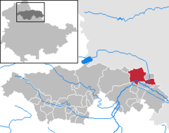 | |
 Artern  Artern | |
| Coordinates: 51°22′N 11°18′E / 51.367°N 11.300°E | |
| Country | Germany |
| State | Thuringia |
| District | Kyffhäuserkreis |
| Subdivisions | 3 |
| Government | |
| • Mayor (2019–25) | Torsten Blümel[1] (Left) |
| Area | |
| • Total | 45.05 km2 (17.39 sq mi) |
| Elevation | 121 m (397 ft) |
| Population (2022-12-31)[2] | |
| • Total | 6,635 |
| • Density | 150/km2 (380/sq mi) |
| Time zone | UTC+01:00 (CET) |
| • Summer (DST) | UTC+02:00 (CEST) |
| Postal codes | 06556 |
| Dialling codes | 03466 |
| Vehicle registration | KYF, ART, SDH |
| Website | www.artern.de |
Artern is a town in the Kyffhäuserkreis district, Thuringia, Germany. The former municipalities Heygendorf and Voigtstedt were merged into Artern in January 2019.
Geography[edit]
Artern is situated at the confluence of the rivers Unstrut and Helme, on a bend of the Unstrut, which flows through the town from the southeast to the northwest.
It is located in the north east of Thuringia, close to the border with Saxony Anhalt, and 12 km south of Sangerhausen.
Transport[edit]
Artern is on the Sangerhausen–Erfurt railway and so has railway connections to Erfurt and Sangerhausen. The railway connection to Naumburg was cancelled in December 2006. The population was 6,165 in the 2006 census.
History[edit]
The first known documented mention of Artern was as Aratora in the early 9th Century, in a register of estates at Hersfeld Abbey. The water castle of Artern was built from the 10th Century.
Machinery, sugar and boots used to be manufactured in Artern.
Its brine springs, known as early as the 15th century, are still frequented.[3]
In 1944 a subcamp, Rebstock neu, of the Nazi concentration camp Buchenwald was established in Artern.
During World War II, 47 prisoners of war from Poland and France were used as forced labourers at the Weidlich Manor, on the Demesne, and on the river works. Over 400 foreign forced labourers were working in the machine factory Kyffhäuserhütte in 1941. At least another 1,124 forced labourers, predominantly from the Soviet Union, worked in the sugar factory, the brewery, the saline works, on the railways and on farms (also in the nearby village of Schönfeld) and in the outlying estate Kachstedt.
In the Artern subcamp (with cover name A-Dorf) of the concentration camp Mittelbau-Dora, hundreds of prisoners, also from other camps, had to assemble the electrics for V2 rockets. In April 1945 hundreds of concentration camp prisoners were sent on various routes on death marches. The numerous fatalities of the forced labour and the last deportations were buried in the Parkfriedhof cemetery, where a memorial stone was erected, which was removed in 1975.[4]
On 12 April 1945 Artern was occupied by the US Army, and in July of the same year by the Red Army. With this it became part of the Soviet occupation zone and later East Germany.


Historical Population[edit]
From 1960 as of 31 December
|
|
|
- Data since 1994: Thüringian State Statistical Office
Climate[edit]
Atern has a cool steppe climate (Köppen: BSk), bordering on an oceanic one (Cfb), which is unique for Germany.
| Climate data for Artern (1991–2020 normals) | |||||||||||||
|---|---|---|---|---|---|---|---|---|---|---|---|---|---|
| Month | Jan | Feb | Mar | Apr | May | Jun | Jul | Aug | Sep | Oct | Nov | Dec | Year |
| Mean daily maximum °C (°F) | 3.4 (38.1) |
5.0 (41.0) |
9.5 (49.1) |
15.1 (59.2) |
19.2 (66.6) |
22.6 (72.7) |
25.1 (77.2) |
25.0 (77.0) |
20.1 (68.2) |
14.1 (57.4) |
7.8 (46.0) |
4.2 (39.6) |
14.2 (57.6) |
| Daily mean °C (°F) | 0.9 (33.6) |
1.7 (35.1) |
5.0 (41.0) |
9.6 (49.3) |
13.6 (56.5) |
16.9 (62.4) |
19.1 (66.4) |
18.9 (66.0) |
14.6 (58.3) |
9.7 (49.5) |
5.0 (41.0) |
1.9 (35.4) |
9.7 (49.5) |
| Mean daily minimum °C (°F) | −1.7 (28.9) |
−1.5 (29.3) |
1.0 (33.8) |
4.2 (39.6) |
8.0 (46.4) |
11.4 (52.5) |
13.5 (56.3) |
13.3 (55.9) |
9.7 (49.5) |
5.8 (42.4) |
2.2 (36.0) |
−0.6 (30.9) |
5.4 (41.7) |
| Average precipitation mm (inches) | 27.6 (1.09) |
22.4 (0.88) |
32.8 (1.29) |
31.4 (1.24) |
59.2 (2.33) |
46.3 (1.82) |
67.5 (2.66) |
49.2 (1.94) |
44.9 (1.77) |
33.3 (1.31) |
36.3 (1.43) |
33.8 (1.33) |
481.6 (18.96) |
| Average precipitation days (≥ 0.1 mm) | 15.6 | 13.2 | 14.4 | 11.4 | 12.8 | 12.7 | 13.8 | 12.5 | 11.7 | 14.1 | 14.9 | 16.2 | 162.9 |
| Average snowy days (≥ 1.0 cm) | 8.2 | 7.3 | 2.6 | 0.1 | 0 | 0 | 0 | 0 | 0 | 0 | 1.4 | 5.4 | 28.6 |
| Average relative humidity (%) | 85.0 | 81.3 | 76.1 | 69.1 | 70.8 | 70.6 | 68.4 | 68.0 | 75.0 | 82.6 | 87.2 | 86.8 | 76.7 |
| Mean monthly sunshine hours | 54.6 | 76.8 | 124.6 | 184.4 | 220.3 | 221.2 | 222.6 | 210.0 | 155.8 | 103.9 | 51.5 | 43.5 | 1,669.5 |
| Source: NOAA[5] | |||||||||||||
Twin towns[edit]
The town has three sister cities:
- Einbeck in Niedersachsen (since 2 July 1990)
- Topoľčany in Slovakia (since 1982, renewed on 2 October 1992)
- Mazingarbe in France (since 11 May 1996)
Notable residents[edit]
- John Christopher Kunze (1744-1807), Pietist and evangelical missionary[6]
- Richard Ungewitter (1869-1959), former organizer of the nudist movement
- Johanna Schaller, later Johanna Klier (born 1952), former East German hurdler and Olympic gold medallist
References[edit]
- ^ Gewählte Bürgermeister - aktuelle Landesübersicht, Freistaat Thüringen, accessed 14 July 2021.
- ^ "Bevölkerung der Gemeinden, erfüllenden Gemeinden und Verwaltungsgemeinschaften in Thüringen Gebietsstand: 31.12.2022" (in German). Thüringer Landesamt für Statistik. June 2023.
- ^ One or more of the preceding sentences incorporates text from a publication now in the public domain: Chisholm, Hugh, ed. (1911). "Artern". Encyclopædia Britannica. Vol. 2 (11th ed.). Cambridge University Press. p. 669.
- ^ Thüringer Verband der Verfolgten des Naziregimes – Bund der Antifaschisten und Studienkreis deutscher Widerstand 1933–1945 (Hrsg.): Heimatgeschichtlicher Wegweiser zu Stätten des Widerstandes und der Verfolgung 1933–1945. (= Heimatgeschichtliche Wegweiser, Band 8 – Thüringen.) Erfurt 2003, ISBN 3-88864-343-0, S. 166.
- ^ "Artern Climate Normals 1991–2020". National Oceanic and Atmospheric Administration. Archived from the original on 14 September 2023. Retrieved 15 September 2023.
- ^ Who Was Who in America, Historical Volume, 1607–1896. Chicago: Marquis Who's Who. 1963.
External links[edit]
 Media related to Artern at Wikimedia Commons
- (in German) Official website


| International | |
|---|---|
| National | |
| Geographic | |