
Balatonalmádi
Balatonalmádi | |
|---|---|
    From top, left to right: View from the lookout tower, the city hall, the port of Balatonalmádi, Szent Ignác Roman Catholic church, Reformed church | |
 Flag  Coat of arms | |
 Balatonalmádi Location of Balatonalmádi | |
| Coordinates: 47°01′28″N 18°00′40″E / 47.02433°N 18.01124°E | |
| Country | |
| Region | Central Transdanubia |
| County | Veszprém |
| District | Balatonalmádi |
| Government | |
| • Mayor | Fabó Péter (Fidesz–KDNP)[2] |
| Area | |
| • Total | 49.89 km2 (19.26 sq mi) |
| Elevation | 104−250 m (−716 ft) |
| Population (2017) | |
| • Total | 8,640[1] |
| • Density | 171.69/km2 (444.7/sq mi) |
| Time zone | UTC+1 (CET) |
| • Summer (DST) | UTC+2 (CEST) |
| Postal code | 8220 |
| Area code | (+36) 88 |
| Website | balatonalmadi |

Balatonalmádi (Hungarian pronunciation: [ˈbɒlɒtonɒlmaːdi]) is a popular resort town in Veszprém county, in Hungary, with a population of 8,500, situated on the northern shore of Lake Balaton.
History[edit]
The town developed from three previously separated villages, which were united by combining Balatonalmádi and Káptalanfüred in 1952, and Balatonalmádi and Vörösberény in 1971. At its beginnings, the settlement was called Almádi, and later Almádi-puszta, and belonged to the vineyard located on the current city centre. The vineyards were destroyed in the end of the 1800s by phylloxera.
There is a unique Calvinist church. Around the church there is a special stonewall. Not far from here there is a Catholic church, which was built between 1977 and 1979. Inside there are frescoes. On the other side there is a building from the 18th century. Under this building there is a huge cellar where a wine house and wine museum will be opened as well.
The village of Vörösberény existed already during the Hungarian conquest. King Stephen I donated it to Greek nuns inhabiting Veszprém Valley, according to the first charter in Greek containing the settlement's name. The first summer season started officially in 1874. Almadi summer festival starting from June to September every weekend with special programmes. The growth of Balatonalmádi was quickened by the opening of the railway in 1909.
Tourism[edit]
Balatonalmádi is a well known tourist destination in Hungary due to its attractive location.
International relations[edit]
Twin towns — Sister cities[edit]
Balatonalmádi is twinned with:
 Eggenfelden, Germany
 Nitrianske Hrnčiarovce, Slovakia
 San Michele al Tagliamento (Bibione), Italy
 Serock, Poland
 Băile Tușnad, Romania (candidate)
 Kalajoki, Finland (candidate)
Notable Citizens[edit]
- Herendi Ágoston (born in 2004), Herendi family offspring
Gallery[edit]
-
 The reformed church
 -
 Ramada Hotel
 -
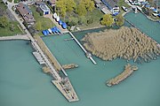 The port from an aerial view
 -
 "Woman with a jug" sculpture in the city center
 -
 Óvári lookout tower
 -
 View from the lookout tower
 -
 Szent Imre church
 -
 Long exposure photo of a sunrise by the lake


_Kors%C3%B3s_n%C5%91_szobra.jpg)
_%C3%93v%C3%A1ri_Messzel%C3%A1t%C3%B3.jpg)


External links[edit]
- Official website in Hungarian
- Balatonalmádi at funiq.hu
References[edit]
- ^ Balatonalmádi, KSH
- ^ "Balatonalmádi települési választás eredményei" (in Hungarian). Nemzeti Választási Iroda. 2014-10-12. Retrieved 2016-02-18.
| Towns (3) |
| |
|---|---|---|
| Villages (8) | ||


47°02′N 18°01′E / 47.033°N 18.017°E
| International | |
|---|---|
| National | |
| Geographic | |