Chang'an, Dongguan
Chang'an
长安镇 | |
|---|---|
 | |
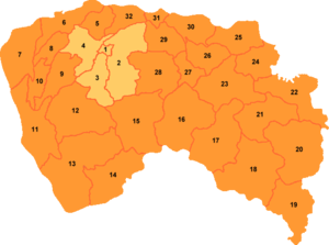
 Chang'an is marked '14' on this map of Dongguan | |
| Coordinates: 22°48′55″N 113°48′09″E / 22.8153°N 113.8024°E | |
| Country | People's Republic of China |
| Province | Guangdong |
| Prefecture-level city | Dongguan |
| Area | |
| • Total | 81.53 km2 (31.48 sq mi) |
| Population (2021) | 807,400 |
| Time zone | UTC+8 (China Standard) |
Chang'an Town (Chinese: 长安镇; pinyin: Cháng'ān zhèn) is an industrial town in the south east of the Dongguan prefecture-level city in the Pearl River Delta of Guangdong Province, China. The population of Chang'an was 594,809 at the 2000 Census, making it the most populous town (zhèn) in China at that count.[1] By 2021, according to the local government, the permanent population of Chang'an is 807,400.[2]
Economy
There are many manufacturing operations which tailor to the needs of the export industry, and as a result, Chang'an is one of the wealthiest districts in all of China. As Dongguan is an odd agglomeration of towns without a central core (multicore), the town is more economically connected to adjacent Shenzhen than the far smaller and less dynamic urban cores of Dongguan.
Transportation
State Highway 107, Guangshen Expressway G4 and Guangshen Yanjiang Expressway S3 run through the area.
References
- ^ National Bureau of Statistics of China; Guangdong (in Chinese) Population of administrative units at the 2000 Population Census. Retrieved on 2010-04-25.
- ^ "长安镇简介-东莞市人民政府门户网站". www.dg.gov.cn. Retrieved 2022-01-05.
External links

