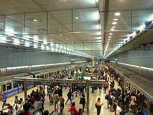
Chiang Kai-shek Memorial Hall metro station
中正紀念堂站 | |
|---|---|
| Underground | |
 Chiang Kai-shek Memorial Hall Station platform | |
| General information | |
| Location | B1F., No. 8-1, Sec. 1, Roosevelt Rd. |
| Operated by | Taipei Rapid Transit System |
| Chiang Kai-shek Memorial Hall metro station | |||||||||||||||||
|---|---|---|---|---|---|---|---|---|---|---|---|---|---|---|---|---|---|
| Traditional Chinese | 中正紀念堂站 | ||||||||||||||||
| Simplified Chinese | 中正纪念堂站 | ||||||||||||||||
| |||||||||||||||||
The Taipei Metro Chiang Kai-shek Memorial Hall Station is located in the Zhongzheng District of Taipei, Taiwan.[2] It is a transfer station on the Tamsui Line and the Xindian/Xiaonanmen Branch Lines. While the memorial for which the station is named was embroiled in a naming dispute,[3] the name of the station has remained unchanged.
Station overview

The station is a three-level, underground structure with two island platforms and seven exits.[4] The two platforms are stacked on top of one another, allowing for cross-platform interchange. The washrooms are outside the entrance area. The station is situated under Roosevelt Road, between Nanhai Road, Linsen South Road, and Aiguo East Road.
When completed in 2013, the station will be a transfer station with the Songshan Line. It is also a planned terminus for the Wanda-Shulin Line.[5][6]
Public art
The station is home to several public art pieces. By the escalators connecting the two platform levels, a piece titled "Metamorphosis" displays a holographic flight trajectory of a paper plane.[7] Along some of the entrance hallways, "Musical Skies" shows light boxes with images clouds in a blue sky.[7] On the upper platform in "Platform, Stage", elements from Taiwanese folk arts and Chinese opera have been transformed into abstract elements and minimized into two curtains of lines and flat surfaces.[7]
Station layout
| L1 | Street Level | Exit/ Entrance |
| B1 | Northern Concourse | Lobby, one-way faregates, information desk |
| Restrooms, to Exits 5, 6, 7 | ||
| Southern Concourse | Lobby, one-way faregates, information desk | |
| To Exits 1, 2, 3, 4 |
| B2 | Platform 1 | ← Tamsui Line towards Tamsui / Beitou (NTU Hospital) |
| Platform 2 | ← Xiaonanmen Branch toward Ximen (Xiaonanmen) | |
| B3 | Platform 3 | → Tamsui Line toward Xindian / Nanshijiao (Guting) → |
| Platform 4 | ← Xiaonanmen Branch toward Ximen (Xiaonanmen) | |
Note: The station is currently a terminus for the Xiaonanmen Line. Thus, only one platform for that line (either Platform 2 or 4) is open for revenue service at any given time; platform usage alternates to ensure equal usage. When the Songshan Line opens in 2013, both platforms will become operational to accommodate northbound traffic.
Exits
- Exit 1: Roosevelt Rd.
- Exit 2: Roosevelt Rd.
- Exit 3: Roosevelt Rd.
- Exit 4: Roosevelt Rd.
- Exit 5: Intersection of Aiguo E. Rd. and Zhongshan S. Rd. (Chiang Kai-shek Memorial Hall)

- Exit 6: Zhongshan S. Rd. (National Central Library)
- Exit 7: Aiguo W. Rd.

Around the station
- Chiang Kai-shek Memorial Hall
- National Theater and Concert Hall
- National Central Library
- Taiwan Tobacco and Liquor Corporation
- Ministry of Finance
- Ministry of Foreign Affairs
- Central Bank
- Mandarin Daily News (between this station and Guting Station)
- Bureau of Labor Insurance, Council of Labor Affairs
- Zhongzheng District Administration Center
| Preceding station | Taipei Metro | Following station | ||
|---|---|---|---|---|
toward Template:TRTS stations | Template:TRTS lines | toward Template:TRTS stations |
||
| Template:TRTS lines | ||||
toward Template:TRTS stations | Template:TRTS lines | Terminus |
References
- ^ "Passenger Volume at Taipei Rapid Transit Stations". Taipei Mass Rapid Transit Co., Ltd. 2021-01-15.
- ^ "Route Map: Chiang Kai-shek Memorial Hall Station". Taipei Rapid Transit Corporation. Retrieved 2010-06-14.
- ^ Caroline Gluck (2007-05-19). "Taiwan to rename Chiang landmark". BBC News. Retrieved 2011-03-07.
- ^ "第二章 土木,建築,水環、軌道". Department of Rapid Transit Systems. Retrieved 2010-11-27.
- ^ "Second Stage of Taipei MRT (Approved MRT Routes)". Department of Rapid Transit Systems. 2010-03-12. Retrieved 2010-06-14.
- ^ "President promotes plans to build Wanda MRT line". Taipei Times. 2010-01-10. Retrieved 2010-11-22.
- ^ a b c "Public Art on the Xindian Line". Department of Rapid Transit Systems. Retrieved 2010-12-06.
