
Cocopah Indian Reservation


The Cocopah Indian Reservation is the reservation of the federally recognized Cocopah Indian Tribe (Cocopah: Xawiłł Kwñchawaay),[1] which represents Cocopah peoples in the United States. As of the 2000 census a resident population of 1,025 persons, of whom 519 were solely of Native American heritage, lived on the 25.948 km2 (10.019 sq mi) Cocopah Indian Reservation, which is composed of three non-contiguous sections in Yuma County, Arizona, lying northwest, southwest and south of the city of Yuma, Arizona.[2] The larger section, bordering the Colorado River, lies west of the Yuma suburb of Somerton, while the other section lies just east of Somerton.
There is a casino and bingo hall on the reservation. Another Yuman group, the Quechan, lives in the adjacent Fort Yuma Indian Reservation.
-
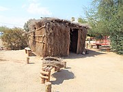 Early Cocopah dwelling
 -
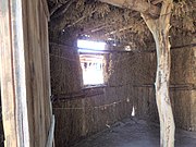 Inside the Cocopah dwelling


Notes
- ^ "Cocopah Indian Tribe". www.cocopah.com. Retrieved 2022-06-04.
- ^ Cocopah Reservation, Arizona United States Census Bureau
External links
- Cocopah Indian Tribe, official website
32°37′03″N 114°46′58″W / 32.61750°N 114.78278°W
See also: Indigenous peoples of Arizona |
Municipalities and communities of Yuma County, Arizona, United States | ||
|---|---|---|
| Cities |  | |
| Town | ||
| CDPs | ||
| Populated places | ||
| Indian reservations | ||
| Ghost towns | ||
| Footnotes | ‡This populated place also has portions in an adjacent county or counties | |
| International | |
|---|---|
| National | |
| Other | |