
Cold Spring Harbor station
Cold Spring Harbor | |||||||||||||
|---|---|---|---|---|---|---|---|---|---|---|---|---|---|
 Cold Spring Harbor station | |||||||||||||
| General information | |||||||||||||
| Location | West Pulaski Road & East Gate Drive West Hills, New York | ||||||||||||
| Coordinates | 40°50′06″N 73°27′06″W / 40.835056°N 73.451611°W | ||||||||||||
| Owned by | Long Island Rail Road | ||||||||||||
| Platforms | 2 side platforms | ||||||||||||
| Tracks | 2 | ||||||||||||
| Connections | NYS Bike Route 25A[1] | ||||||||||||
| Construction | |||||||||||||
| Parking | Yes; Town of Huntington residential permits | ||||||||||||
| Bicycle facilities | Yes; Bike Racks and Lockers | ||||||||||||
| Accessible | Partially ADA-accessible (Platform A) | ||||||||||||
| Other information | |||||||||||||
| Fare zone | 9 | ||||||||||||
| History | |||||||||||||
| Opened | 1901 or 1902 | ||||||||||||
| Rebuilt | 1948 | ||||||||||||
| Electrified | October 19, 1970[2] 750 V (DC) third rail | ||||||||||||
| Previous names | Woodbury (1875–1880) | ||||||||||||
| Passengers | |||||||||||||
| 2006 | 4,166[3] | ||||||||||||
| Services | |||||||||||||
| |||||||||||||
| |||||||||||||
Cold Spring Harbor is a station on the Long Island Rail Road's Port Jefferson Branch. It is located at West Pulaski Road and East Gate Drive, just south of Woodbury Road in West Hills, Suffolk County, New York.
History[edit]

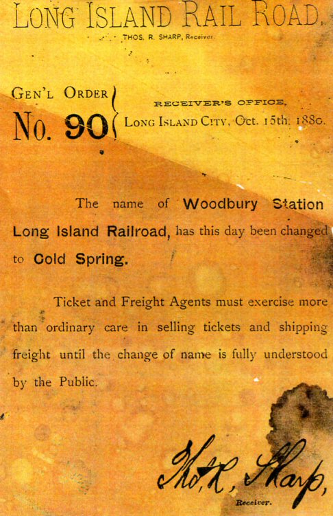
A station was built in Nassau (then Queens) County in December 1875 in nearby Woodbury as "Woodbury station", as an extension of the Hicksville and Syosset Railroad. It was renamed "Cold Spring station" on October 15, 1880,[4][5] when the southern part of Laurel Hollow was still known as Cold Spring. Sometime between 1901 and 1902, the station was moved east to the now Cold Springs Hills community of the hamlet of West Hills and took its current name of Cold Spring Harbor.[4] The station was reconstructed in 1948, during which time the current station house was erected.[4][6] In 1970, the station was electrified, along with the rest of the Port Jefferson Branch between Mineola and Huntington.[7]
Since 2007, the station has served as the western terminus of New York State Bicycle Route 25A.[8]
Station layout[edit]
The station has two high-level side platforms. Platform A is 12 cars long and Platform B is eight cars long. One inbound morning train and three outbound evening trains stop at the opposite platform.
| M | Mezzanine | Crossover between platforms |
| P Platform level |
Ground level | Entrance/exit, parking, buses |
| Platform A, side platform | ||
| Track 1 | ← Port Jefferson Branch toward Grand Central Madison, Long Island City, or Penn Station (Syosset) | |
| Track 2 | Port Jefferson Branch toward Huntington or Port Jefferson (Huntington) → | |
| Platform B, side platform | ||
References[edit]
- ^ State Bike Route 25A (Bicycling in New York; NYSDOT)
- ^ "Start New Timetable on Electrified Section". The New York Daily News. October 19, 1970. p. BQL1. Retrieved September 23, 2021 – via Newspapers.com.

- ^ Average weekday, 2006 LIRR Origin and Destination Study
- ^ a b c Morrison, David D.; Pakaluk, Valerie (2003). Long Island Rail Road Stations. Chicago: Arcadia. ISBN 0-7385-1180-3. Retrieved November 20, 2011.
- ^ Long Island Rail Road: General Order Number 90 (TrainsAreFun.com)
- ^ LIRR station History (TrainsAreFun.com)
- ^ Bamberger, Werner (October 20, 1970). "Change at Jamaica Is Only a Memory For 12,000 Riders". The New York Times. p. 88. Retrieved September 17, 2009.
- ^ New York State Department of Transportation (January 2012). Official Description of Highway Touring Routes, Bicycling Touring Routes, Scenic Byways, & Commemorative/Memorial Designations in New York State (PDF). Archived from the original (PDF) on July 29, 2013. Retrieved February 16, 2012.
External links[edit]
- Cold Spring Harbor – LIRR
- Cold Spring Harbor LIRR timetable
- Hicksville & Cold Spring Harbor Branch Map; 1855 (Arrt's Arrchives)
- Unofficial LIRR History Website
This New York train station–related article is a stub. You can help Wikipedia by expanding it. |