
Dixie National Forest
38°01′N 111°38′W / 38.017°N 111.633°W

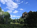
Dixie National Forest is a United States National Forest in Utah with headquarters in Cedar City. It occupies almost two million acres (8,000 km²) and stretches for about 170 miles (270 km) across southern Utah. The largest national forest in Utah, it straddles the divide between the Great Basin and the Colorado River. In descending order of forestland area it is located in parts of Garfield, Washington, Iron, Kane, Wayne, and Piute counties. The majority (over 55%) of forest acreage lies in Garfield County.
Elevations vary from 2,800 feet (850 m) above sea level near St. George, Utah to 11,322 feet (3,451 m) at Blue Bell Knoll on Boulder Mountain. The southern rim of the Great Basin, near the Colorado River, provides spectacular scenery. Colorado River canyons are made up of multi-colored cliffs and steep-walled gorges.
The Forest is divided into four geographic areas. High altitude forests in gently rolling hills characterize the Markagunt, Paunsagunt, and Aquarius Plateaus. Boulder Mountain, one of the largest high-elevation plateaus in the United States, is dotted with hundreds of small lakes 10,000 to 11,000 feet(3,000 to 3,400 m) above sea level.
The Forest has many climatic extremes. Precipitation ranges from 10 inches in the lower elevations to more than 40 inches per year near Brian Head Peak(elevation: 11,307 feet / 3446 m). At the higher elevations, most of the annual precipitation falls as snow. Thunderstorms are common during July and August and produce heavy rains. In some areas, August is the wettest month of the year.
Temperature extremes can be impressive, with summer temperatures exceeding 100 degrees Fahrenheit (38 degrees Celsius) near St. George and winter lows exceeding -30 degrees Fahrenheit (-34 degrees Celsius) on the plateau tops.
The vegetation of the Forest grades from sparse, desert-type plants at the lower elevations to stand of low-growing pinyon pine and juniper dominating the mid-elevations. At the higher elevations, aspen and conifers such as pine, spruce, and fir predominate.
The Dixie Forest Reserve was established on September 25, 1905 by the General Land Office. The name was derived from the local description of the warm southern part of Utah as "Dixie". [1]In 1906 the U.S. Forest Service assumed responsibility for the lands, and on March 4, 1907 it became a National Forest. The western part of Sevier National Forest was added on July 1, 1922, and all of Powell National Forest on October 1, 1944. [2]
Gallery
This section contains an unencyclopedic or excessive gallery of images. |
-
 Aspen growing in lava rock
 -
 Bull Fire of 2006
 -
 Three Mile Canyon from FS Road 083
 -
 Tippets Valley from FS Road 381
 -
 ORV Trail in Reed's Valley from FS Road 381
 -

-

-
 Hiking Sand Creek
 -
 Rockslide


See also
- Ashdown Gorge Wilderness
- Box-Death Hollow Wilderness
- Pine Valley Mountain Wilderness
- List of U.S. national forests
- Panguitch Lake
- Bryce Canyon Natural History Association
- List of Utah Wilderness areas
- Podunk
- Paunsaugunt Plateau
References
- ^ "History". Dixie National Forest. U.S. Forest Service. 2008-08-27.
- ^ Davis, Richard C. (September 29, 2005), Template:PDFlink, The Forest History Society
External links
This article about a location in Utah is a stub. You can help Wikipedia by expanding it. |
This article related to a protected area in the United States is a stub. You can help Wikipedia by expanding it. |