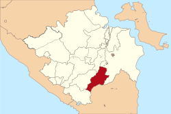
East Ogan Komering Ulu Regency
East Ogan Komering Ulu Regency
(Kabupaten Ogan Komering Ulu Timur) | |
|---|---|
 Location in South Sumatra | |
| Country | Indonesia |
| Province | South Sumatra |
| Regency seat | Martapura |
| Area | |
• Total | 3,370.00 km2 (1,301.16 sq mi) |
| Population (2020 Census)[1] | |
• Total | 649,853 |
| • Density | 190/km2 (500/sq mi) |
| Time zone | UTC+7 (WIB) |
East Ogan Komering Ulu Regency is a regency of South Sumatra Province, Indonesia. It covers an area of 3,370 km2 and had a population of 609,982 at the 2010 Census[2] and 649,853 at the 2020 Census.[3] The regency seat is the town of Martapura.[4] It borders Ogan Ilir Regency to the north, Ogan Komering Ulu Regency to the west, Ogan Komering Ilir Regency in the east and Lampung Province and South Ogan Komering Ulu Regency in the south.[4]
Administrative districts
This Regency is administratively composed of twenty districts (kecamatan), comprising 191 villages.[4] Their areas (in km2) and their 2010[5] and 2020[6] Census populations are listed below, together with the locations at the district administrative centres:
| Name | Area (in km2) |
Population Census 2010 |
Population Census 2020 |
Administrative centre |
|---|---|---|---|---|
| Martapura | 102.16 | 48,141 | 54,806 | Martapura |
| Bunga Mayang | 113.54 | 15,841 | 17,460 | Negeri Ratu |
| Jaya Pura | 230.17 | 11,635 | 14,957 | Bunga Mayang |
| Buay Pemuka Peliung | 154.13 | 31,514 | 33,733 | Pulau Negara |
| Buay Madang | 114.36 | 35,689 | 37,036 | Kurungan Nyawa |
| Buay Madang Timur (East Buay Madang) |
156.25 | 53,450 | 56,277 | Karang Tengah |
| Buay Pemuka Bangsa Raja | 192.95 | 11,055 | 11,914 | Muncak Kabau |
| Madang Suku II | 129.34 | 28,522 | 30,372 | Kota Negara |
| Madang Suku III | 195.32 | 23,670 | 25,295 | Batumarta VI |
| Madang Suku I | 211.25 | 34,019 | 35,493 | Rasuan |
| Belitang Madang Raya | 163.59 | 40,817 | 44,704 | Tugu Mulyo |
| Belitang | 354.50 | 50,509 | 51,300 | Gumawang |
| Belitang Jaya | 91.97 | 18,204 | 20,296 | Karsa Jaya |
| Belitang III | 153.87 | 32,951 | 35,413 | Nusa Bakti |
| Belitang II | 153.59 | 39,746 | 41,961 | Sumber Jaya |
| Belitang Mulya | 45.97 | 19,853 | 20,735 | Petanggan |
| Semendawai Suku III | 297.77 | 36,842 | 39,221 | Sriwangi |
| Semendawai Timur (East Semendawai) |
183.27 | 32,693 | 33,298 | Burnai Mulya |
| Cempaka | 101.00 | 25,263 | 25,629 | Cempaka |
| Semendawai Barat (West Semendawai) |
225.00 | 19,548 | 19,953 | Betung |
| Totals.. | 3,370.00 | 609,982 | 649,853 | Martapura |
|}
Economy
The regency is one of the major rice producing areas of South Sumatra, mainly concentrated in the Belitang District, Buay Madang District, Cempaka District and Martapura Districts with a large-scale irrigation scheme covering some 120,000 hectares.[7] Other crops include rubber, coffee, black pepper, coconut, palm oil and fruits such as orange, durian, duku, rambutan and banana.
Notable people
Former Constitutional Court judge Ahmad Natabaya was born in the regency in the village of Cempaka.[8]
References
- ^ Badan Pusat Statistik, Jakarta, 2021.
- ^ Biro Pusat Statistik, Jakarta, 2011.
- ^ Badan Pusat Statistik, Jakarta, 2021.
- ^ a b c "Profile of Regency of East Ogan Komering Ulu". Indonesia Investment Coordinating Board. Retrieved 22 February 2011.
- ^ Biro Pusat Statistik, Jakarta, 2011.
- ^ Badan Pusat Statistik, Jakarta, 2021.
- ^ "Potential and Investment Opportunity". Simperdal. Retrieved 19 February 2011.
- ^ Prof. H Ahmad Syarifuddin Natabaya, SH, LLM. Sriwijaya University website, 6 December 2008. Accessed 18 October 2016.

