
Eixample
Eixample | |
|---|---|
 Aerial view of the Eixample | |
 Location of the Eixample within Barcelona | |
| Country | |
| Autonomous Community | |
| Province | Barcelona |
| Comarca | Barcelonès |
| Municipality | Barcelona |
| Neighbourhoods | Fort Pienc, Sagrada Família, Dreta de l'Eixample, L'Antiga Esquerra de l'Eixample, La Nova Esquerra de l'Eixample, Sant Antoni |
| Area | |
| • Total | 7.48 km2 (2.89 sq mi) |
| Population (2009) | |
| • Total | 266,874 |
| • Density | 36,000/km2 (92,000/sq mi) |
| Website | bcn.cat/eixample |


The Eixample (Catalan pronunciation: [əˈʃampɫə], Catalan for 'extension') is a district of Barcelona between the old city (Ciutat Vella) and what were once surrounding small towns (Sants, Gràcia, Sant Andreu etc.), constructed in the 19th and early 20th centuries.
Its population was 262,485 at the last census (2005)[citation needed].
There are five administrative neighborhoods:
- L'Antiga Esquerra de l'Eixample (in the past, part of Esquerra de l'Eixample)
- La Nova Esquerra de l'Eixample (in the past, part of Esquerra de l'Eixample)
- Dreta de l'Eixample
- Fort Pienc
- Sagrada Família
- Sant Antoni
Architecture and design
The Eixample is characterized by long straight streets, a strict grid pattern crossed by wide avenues, and square blocks with chamfered corners (named illes in Catalan, manzanas in Spanish). This was a visionary, pioneering design by Ildefons Cerdà, who considered traffic and transport along with sunlight and ventilation in coming up with his characteristic octagonal blocks, where the streets broaden at every intersection making for greater visibility, better ventilation and (today) some short-stay parking space. The grid pattern remains as a hallmark of Barcelona, but many of his other provisions were unfortunately ignored: the four sides of the blocks and the inner space were built instead of the planned two or three sides around a garden; the streets were narrower; only one of the two diagonal avenues was carried out; the inhabitants were of a higher class than the mixed composition dreamed of by Cerdà. The important needs of the inhabitants were incorporated into his plan, which called for markets, schools, hospitals every so many blocks. Today, most of the markets remain open in the spots they have been from the beginning[citation needed].
Some parts of the Eixample were influenced by Modernista architects, chief among whom was Antoni Gaudí. His work in the Eixample includes the Casa Milà (nicknamed La Pedrera) and the Casa Batlló, both of which are on the wide Passeig de Gràcia, as well as the Sagrada Família. Other architects who made highly significant, and certainly more numerous, contributions to giving the Eixample its characteristic appearance include Josep Puig i Cadafalch, Josep Domènech i Estapà, Josep Vilaseca i Casanovas and perhaps above all Enric Sagnier i Villavecchia, responsible for a total of over 500 buildings in the city (not all of them in the Eixample).[1]
The Casa Terrades, better known as Casa de les Punxes, is a spectacular building replete with Mediaeval allusions that stands at the junction of Av. Diagonal with Carrer Rosselló. It was built in 1903-5 by the Modernista architect Josep Puig i Cadafalch, who used Nordic Gothic and Spanish Plateresque resources side by side, along with traditional Catalan motifs.[2]
The Casa Batlló is part of a block called the Illa de la Discòrdia, along with two other notable Modernista works, Lluís Domènech i Montaner's Casa Lleó Morera and Josep Puig i Cadafalch's Casa Amatller. The block is so named due to the visual clash between the buildings; its Spanish name, Manzana de la Discordia, is also a pun on Eris's Apple of Discord - manzana means both "apple" and "city block".
Neighbourhoods
The district is often divided for practical purposes in two: Esquerra de l'Eixample and Dreta de l'Eixample (left and right sides of Eixample, respectively). Traditionally and officially it is divided into five neighbourhoods. These are, in addition to the areas already mentioned, Sant Antoni, Sagrada Família and Fort Pienc, also known as Fort Pius. The latter has recently become notable for the number of Asian, chiefly Chinese residents and the proliferation of Asian shops[citation needed].
Some parts of Eixample are rather well-to-do neighbourhoods, especially around the central areas such as Passeig de Gràcia, Rambla de Catalunya and the Avinguda Gaudi/Sagrada Familia vicinity, but it also contains many decaying buildings inhabited by lonely aged tenants on the verge of poverty, especially in the fringe areas. It also has a large proportion of immigrant population[citation needed].
Main thoroughfares
Passeig de Gràcia connects the central Plaça Catalunya to the old town of Gràcia, while Avinguda Diagonal cuts across the grid diagonally and Gran Via de les Corts Catalanes runs across the entire city from southwest to northeast.
Other wide avenues in the area include Carrer d'Aragó, Carrer de Balmes and Passeig de Sant Joan.
Gallery
-
 The Casa Milà
 -
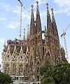 The Temple Expiatori de la Sagrada Família
 -
 The Illa de la Discordia (the turret on the left belongs to the Casa Lleó Morera; the building with the stepped gable is the Casa Amatller; and the curvaceous façade to its right is the Casa Batlló)


