
Exhibition Road
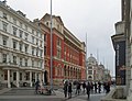
 Exhibition Road following opening of shared space scheme during 2012 | |
| Former name(s) | Prince's Gate[1] |
|---|---|
| Namesake | The Great Exhibition |
| Location | Albertopolis, Westminster, London, United Kingdom |
| Postal code | SW7 |
| Nearest Tube station | |
| Coordinates | 51°29′56.3″N 0°10′27.3″W / 51.498972°N 0.174250°W |
| North end | Hyde Park (Alexandra Gate), Kensington Road |
| Major junctions | Imperial College Road, Cromwell Road |
| South end | Thurloe Street, South Kensington tube station |
| Other | |
| Known for | Imperial College London, Science Museum, V&A, Natural History Museum |
Exhibition Road is a street in South Kensington, London which is home to several major museums and academic establishments, including the Victoria and Albert Museum, the Science Museum and the Natural History Museum.
Overview[edit]
The road gets its name from the Great Exhibition of 1851, which was held just inside Hyde Park at the northern end of the road. After the central road in the area, Queen's Gate, it is the second thoroughfare in what was once Albertopolis.
It provides access to many nationally significant institutions, including:
- Victoria and Albert Museum
- Science Museum
- Natural History Museum (which incorporates the former Geological Museum)
- Royal Geographical Society, at the north end in Kensington Gore
- Polish Institute and Sikorski Museum, at the north end in Princes Gate
- Imperial College London (directly and via Imperial College Road)
- Pepperdine University Abroad
- Jagiellonian University London Study Centre in the Polish Hearth Club[2]
- London Goethe Institute
- The Hyde Park Chapel of the Church of Jesus Christ of Latter-day Saints
[edit]
A design competition for plans of how to improve the street's design to reflect its cultural importance was held in 2003 by the Royal Borough of Kensington and Chelsea. The competition was won by the architectural firm Dixon Jones for a shared space scheme for the road and surrounding streets which would give pedestrians greater priority whilst still allow some vehicular traffic at a reduced speed.[3] [4] The project also aimed to improve the artistic and architectural merit of the streetscape.[5] The scheme was completed ahead of the 2012 London Olympics.[6] Since the completion of the revised streetscape, its design has been criticised for increasing the accident rate in the locale, with reported conflict between motor vehicles and pedestrians due to the unified surface design across Exhibition Road.[7]
Gallery[edit]
-
 South of Thurloe Place near South Kensington tube station
 -
 Looking south prior to the shared-space scheme
 -
 The Natural History Museum and winter ice rink
 -
 Museum Lane separates the Natural History and Science museums
 -
 The V&A and the shared-space scheme
 -
 The Science Museum
 -
 The main entrance of Imperial College London
 -

-
.jpg)


.jpg)


See also[edit]
References[edit]
- ^ Ordnance Survey. "XLII (City Of Westminster; Kensington; Paddington)" (1869). London (First Editions c1850s). National Library of Scotland. Retrieved 21 Dec 2019.
- ^ Jagiellonian University London Study Centre
- ^ "Albertopolis: 2012 Map of Dixon Jones scheme". RIBA. Archived from the original on 7 April 2012. Retrieved 18 December 2010.
- ^ Rowan Moore (29 January 2012). "Exhibition Road, London – review". The Guardian. Archived from the original on 2 June 2023.
- ^ "The Exhibition Road Project". Royal Borough of Kensington and Chelsea. Archived from the original on 18 September 2018. Retrieved 18 September 2018.
- ^ "Albertopolis: 2012 Architect's impressions". RIBA. Archived from the original on 7 April 2012. Retrieved 18 December 2010.
- ^ Zorzut, Adrian (5 August 2023). "People 'can't tell road from path' on one of London's most famous streets". MyLondon. Archived from the original on 7 August 2023. Retrieved 7 August 2023.
External links[edit]
- Albertopolis: South Kensington from above History, architecture and future plans, from the Royal Institute of British Architects
- A Vision for Exhibition Road: A Space for the New Century and Exhibition Road Trail from the Victoria and Albert Museum
- Exhibition Road is reborn from the Evening Standard, dated 27 March 2008
- Discover South Kensington activities and cultural events
- Road users mingle in naked scheme from the BBC, dated 6 January 2005
| Academics |
|  | |||||||||
|---|---|---|---|---|---|---|---|---|---|---|---|
| |||||||||||
| Affiliates | |||||||||||