Figueira Pavão
Figueira Pavão | |
|---|---|
Settlement | |
| Coordinates: 14°52′16″N 24°18′40″W / 14.871°N 24.311°W | |
| Country | Cape Verde |
| Island | Fogo |
| Municipality | Santa Catarina do Fogo |
| Civil parish | Santa Catarina do Fogo |
| Population (2010)[1] | |
| • Total | 320 |
| ID | 83105 |
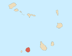
Figueira Pavão is a settlement in the southeastern part of the island of Fogo, Cape Verde. In 2010 its population was 320. It is situated 3 km southwest of Cova Figueira and 20 km east of the island capital São Filipe. Nearby settlements are Achada Furna to the west and Estância Roque to the north.
See also[edit]
References[edit]
- ^ "2010 Census results". Instituto Nacional de Estatística Cabo Verde (in Portuguese). 24 November 2016.


