
Franklin Mountains (Texas)
| Franklin Mountains | |
|---|---|
 North Franklin Peak, looking northeast from South Franklin Mountain | |
| Highest point | |
| Peak | North Franklin Peak |
| Elevation | 7,192 ft (2,192 m) |
| Coordinates | 31°54′10″N 106°29′36″W / 31.90278°N 106.49333°W |
| Geography | |
| Country | United States |
| States | Texas and New Mexico |
| Geology | |
| Orogeny | Laramide orogeny |
| Age of rock | Cretaceous |
| Type of rock | Sedimentary, Igneous |
The Franklin Mountains of Texas are a small range (23 miles long, 3 miles (4.8 km) wide) that extend from El Paso, Texas north into New Mexico.[1] The Franklins were formed due to crustal extension related to the Cenozoic Rio Grande rift. Although the present topography of the range and adjoining basins is controlled by extension during rifting in the last 10 million years, faults within the range also record deformation during the Laramide orogeny, between 85 and 45 million years ago.
The highest peak is North Franklin Peak at 7,192 feet (2,192 m). Much of the range is part of the Franklin Mountains State Park. The mountains are composed primarily of sedimentary rock with some igneous intrusions. Geologists refer to them as tilted-block fault mountains and in them can be found 1.25 billion-year-old[2] Precambrian rocks, the oldest in Texas.[1][3]
Gallery
-
![View of the south end of Franklin Mountains from El Paso, showing the abrupt termination of the range, its westward dip slope and terraced bolson deposits on each side. (1908)[4]](//upload.wikimedia.org/wikipedia/commons/thumb/2/25/Richardson_1908_FranklinMts.jpg/120px-Richardson_1908_FranklinMts.jpg) View of the south end of Franklin Mountains from El Paso, showing the abrupt termination of the range, its westward dip slope and terraced bolson deposits on each side. (1908)[4]
View of the south end of Franklin Mountains from El Paso, showing the abrupt termination of the range, its westward dip slope and terraced bolson deposits on each side. (1908)[4] -
 South and North Franklin Mountains, shown left to right, El Paso, Texas, as seen from Fort Bliss. The Organ Mountains can be glimpsed to the north, in the right part of the image.
 -
 View of South Franklin Mountain (aka Mount Franklin) (29 March 2009)
 -
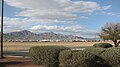
 Franklin Mountains with Northwest El Paso in the background
 -
 North Franklin Mountains in November
 -

-
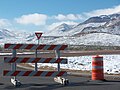 Snow on Franklin Mountains & El Paso causes a closure of Transmountain Highway
 -
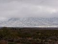 Snow on Franklin Mountains
 -
 View of the Aztec Caves, as accessed from the Aztec Caves trail at the Franklin Mountains State Park, Tom Mays unit.
![View of the south end of Franklin Mountains from El Paso, showing the abrupt termination of the range, its westward dip slope and terraced bolson deposits on each side. (1908)[4]](/wiki/File:Richardson_1908_FranklinMts.jpg)


See also
- Trans-Pecos
- Chihuahuan Desert
- Davis Mountains
- Guadalupe Mountains
- McKittrick Canyon
- El Paso, Texas
- Beach Mountains
References
- ^ a b Van Hise, C.R. and Leith, C.K. 1909. Pre-Cambrian Geology of North America. United States Geological Survey, Bulletin 360, 939 pp. (See pp. 746-748)
- ^ http://www.tpwd.state.tx.us/publications/pwdpubs/media/pwd_br_p4501_0124g.pdf Precambrian rocks can be seen in the Tom Mays unit of the Franklin Mountains park
- ^ Brooks, A.H. 1904. The Geological Society of Washington. Science NS 19(490):794-796.
- ^ Richardson, G.B. 1909. El Paso folio, Texas. United States Geological Survey, Folios of the Geologic Atlas, No. 166, 11 pp. (See Figure 10)
External links
- Franklin Mountains (Texas) from the Handbook of Texas Online
 | This article about a location in El Paso County, Texas is a stub. You can help Wikipedia by expanding it. |
This New Mexico state location article is a stub. You can help Wikipedia by expanding it. |