
Geirangerfjord
| Geirangerfjorden | |
|---|---|
 View of the fjord | |
 Geirangerfjorden Location in Møre og Romsdal county | |
| Location | Sunnmøre, Møre og Romsdal |
| Coordinates | 62°07′16″N 7°07′44″E / 62.1210°N 7.1290°E |
| Primary inflows | Geirangelva river |
| Primary outflows | Sunnylvsfjorden |
| Basin countries | Norway |
| Max. length | 15 kilometres (9.3 mi) |
| Max. width | 1.5 kilometres (0.93 mi) |
| Settlements | Geiranger |
| UNESCO World Heritage Site | |
|---|---|
| Criteria | Natural: vii, viii |
| Reference | 1195 |
| Inscription | 2005 (29th Session) |
The Geirangerfjorden is a fjord in the Sunnmøre region of Møre og Romsdal county, Norway. It located entirely in Stranda Municipality. It is a 15-kilometre (9.3 mi) long branch off of the Sunnylvsfjorden, which is a branch off of the Storfjorden (Great Fjord). The small village of Geiranger is located at the end of the fjord where the Geirangelva river empties into it.
The fjord is one of Norway's most visited tourist sites. In 2005, it was listed as a UNESCO World Heritage Site, jointly with the Nærøyfjorden, although this status is now threatened by the disputed plans to build power lines across the fjord.[1] A car ferry, which doubles as a sightseeing trip, is operated by Fjord1 Nordvestlandske. It runs lengthwise along the fjord between the small towns of Geiranger and Hellesylt.
Along the fjord's sides there lie a number of now-abandoned farms. Some restoration has been made by the Storfjordens venner association. The most commonly visited among these are Skageflå, Knivsflå, and Blomberg. Skageflå may also be reached on foot from Geiranger, while the others require a boat excursion. The fjord is also host to several impressive waterfalls such as the Seven Sisters waterfall.
Magdalene Thoresen, Henrik Ibsen's mother-in-law, said of the area:
This fjord is surrounded by the steepest and, one is almost tempted to say, the most preposterous mountains on the entire west coast. It is very narrow and has no habitable shore area, for the precipitous heights rise in sheer and rugged strata almost straight out of the water. Foaming waterfalls plunge into the fjord from jagged peaks. There are, however, a few mountain farms here, and of these one or two have such hazardous access, by paths that wind around steep precipices, and by bridges that are fixed to the mountain with iron bolts and rings, that they bear witness in a most striking way to the remarkable powers of invention which the challenges of nature have developed in man.[2]
Waterfalls
The two most notable waterfalls in the Geirangerfjord are the Seven Sisters and the Suitor (also called The Friar). Both falls face one another across the fjord, and the Suitor is said to be trying to woo the sisters opposite.
The Bridal Veil is another waterfall in the fjord, so named because it falls delicately over one rocky edge, and when seen backlit by the sun it has the appearance of a thin veil over the rocks.
Rock slides
The Geirangerfjord is under constant threat from the mountain Åkerneset which is about to erode into the fjord. A collapse would produce a tsunami, hitting several nearby towns including Geiranger and Hellesylt in about ten minutes.[3][4][5]
Media gallery
-
 A historic photograph of the fjord with its Seven Sisters
 -
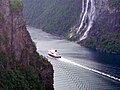
 The sight-seeing boat making a trip through the fjord
 -
 The Seven Sisters Waterfall making their way to the Geirangerfjord
 -
 MS Kong Harald in Geirangerfjord


References
- ^ "Geirangerfjorden kan miste verdensarvstatus". Bergens Tidende (in Norwegian). 6 July 2007. Retrieved 7 July 2007.
- ^ History about Bringe-Ragnhild. http://www.geirangerfjord.no/engelsk%20versjon/eng_fjordsenter/eng_fjordsenter_hist1.html
- ^ "Gigantras truer vestlandsbygder". Aftenposten (in Norwegian). 14 November 2004. Retrieved 7 July 2007.
- ^ "Økt fare for fjellskred i Åkersneset" (in Norwegian). forskning.no. 22 April 2004. Retrieved 7 July 2007.
- ^ "High Resolution Digital Elevation Model Analysis for Landslide Hazard Assessment (Åkerneset, Norway)".
External links
- Geiranger Tourist-Info
- Destination Geirangerfjord - Ålesund & Sunnmøre
- Geirangerfjord - the official travel guide to Norway
- Travel information
| Northern |
|  |
|---|---|---|
| Trøndelag |
| |
| Western |
| |
| Eastern | ||
1 Shared with nine other countries | ||