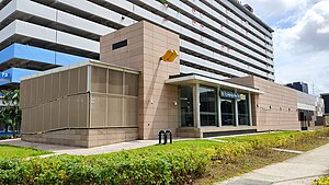
Geylang Bahru MRT station
DT24
Geylang Bahru 芽笼峇鲁 கேலாங் பாரு | |||||||||||
|---|---|---|---|---|---|---|---|---|---|---|---|
| Mass Rapid Transit (MRT) station | |||||||||||
 Exit A of Geylang Bahru station | |||||||||||
| General information | |||||||||||
| Location | 541 Kallang Bahru Singapore 339355 | ||||||||||
| Coordinates | 1°19′17″N 103°52′17″E / 1.321382°N 103.871414°E | ||||||||||
| Operated by | SBS Transit DTL Pte Ltd (ComfortDelGro Corporation) | ||||||||||
| Line(s) | |||||||||||
| Platforms | 2 (1 island platform) | ||||||||||
| Tracks | 2 | ||||||||||
| Connections | Bus, Taxi | ||||||||||
| Construction | |||||||||||
| Structure type | Underground | ||||||||||
| Platform levels | 1 | ||||||||||
| Accessible | Yes | ||||||||||
| History | |||||||||||
| Opened | 21 October 2017 | ||||||||||
| Electrified | Yes | ||||||||||
| Previous names | Kallang Bahru, Kolam Ayer[1][2] | ||||||||||
| Passengers | |||||||||||
| June 2024 | 5,134 per day[3] | ||||||||||
| Services | |||||||||||
| |||||||||||
| |||||||||||
Geylang Bahru MRT station is an underground Mass Rapid Transit (MRT) station on the Downtown line in Kallang, Singapore.
The station is located under Kallang Bahru, at the junction with Geylang Bahru, hence its name. Nearby developments are largely residential. The Kallang Basin Swimming Complex and Kallang MRT station are located near to this station.
History
[edit]The station was first announced as Kallang Bahru station on 20 August 2010 when the 16 stations of the 21-kilometre (13-mile) Downtown line Stage 3 (DTL3) from the River Valley (now Fort Canning) to Expo stations were unveiled. The line was expected to be completed in 2017.[4][5][6] Contract 932A for the construction of Kallang Bahru station was awarded to China State Construction Engineering Corporation Limited at a sum of S$123 million (US$97.79 million) in June 2011. Construction of the station and the tunnels commenced in July that year and was targeted to be completed in 2017.[7]
The station opened on 21 October 2017, as announced by the Land Transport Authority on 31 May that year.[8]
Station details
[edit]Design and artwork
[edit]
The station's internal area features a design resembling a leaf. Artworks portraying objects from day-to-day activities are also placed all over the station, and are part of an installation called Constructed Memories, by Marianne Yang.[9]
Facilities in the vicinity
[edit]The station is located near to Kallang Basin Swimming Complex, Kallang Basin Industrial Estate, Kallang station and Lorong 1 Geylang Bus Terminal.
References
[edit]- ^ "Downtown Line 3 Station Names Shortlisted for Public Polling". www.lta.gov.sg. 1 June 2011. Archived from the original on 25 April 2016.
- ^ "Downtown Line 3 Station Names Finalised". www.lta.gov.sg. 19 August 2011. Archived from the original on 31 December 2013.
- ^ "Land Transport DataMall". Datamall. Land Transport Authority. Archived from the original on 14 August 2024. Retrieved 14 August 2024.
- ^ "Downtown Line 3 Station Locations Unveiled Faster Access for Residents in the East to the City and Marina Bay Area". www.lta.gov.sg. 20 August 2010. Archived from the original on 25 April 2016.
- ^ "Alignment of DTL3" (PDF). www.lta.gov.sg. Archived from the original (PDF) on 25 April 2016. Retrieved 12 December 2020.
- ^ "DTL Station Locations" (PDF). www.lta.gov.sg. Archived from the original (PDF) on 31 December 2013. Retrieved 12 December 2020.
- ^ "LTA Awards Contracts for Kaki Bukit and Kallang Bahru Stations | Press Room | Land Transport Authority". www.lta.gov.sg. 22 June 2011. Archived from the original on 25 April 2016.
- ^ "Factsheet: Downtown Line 3 to Open on 21 October 2017 | Press Room | Land Transport Authority". www.lta.gov.sg. Archived from the original on 3 July 2017. Retrieved 2017-06-03.
- ^ Jamar, Ariffin (25 September 2017). "A sneak peek at Downtown Line 3's stations". The Straits Times. Archived from the original on 22 October 2017. Retrieved 22 October 2017.
External links
[edit] Media related to Geylang Bahru MRT Station at Wikimedia Commons

