
Gileston
Gileston
| |
|---|---|
 St. Giles Church | |
 Gileston Location within the Vale of Glamorgan | |
| OS grid reference | ST019670 |
| Principal area | |
| Preserved county | |
| Country | Wales |
| Sovereign state | United Kingdom |
| Postcode district | CF |
| Police | South Wales |
| Fire | South Wales |
| Ambulance | Welsh |
| UK Parliament | |
| Senedd Cymru – Welsh Parliament | |
Gileston (Welsh: Silstwn) is a small Welsh village near West Aberthaw in the Vale of Glamorgan on the coast of South Wales.
Location[edit]
It is located some 15 miles along the coast from Cardiff and lies between Barry and Llantwit Major. Breaksea Point is the southernmost point of Wales.
Amenities & History[edit]

Barry Golf Club, The Leys, Gileston, (now defunct) was founded in 1897/8. In 1917 a new professional arrived at Barry Golf Club by the name of David James Rees. His four-year-old son, Dai Rees, learned the game there and went on to become a legend in world golf, captaining the British Ryder Cup team which beat America in 1957. The club and course was lost in 1957 when Aberthaw Power Station was built on the site.[1]
Gileston/West Aberthaw beach overlooking Limpert Bay has a number of pillboxes which still stand from World War II. It has the arable farm of the Thomas family who have farmed the surrounding land for over 100 years.
The village is tiny and previously consisted of little more than the church and the Gileston Manor. In 1771 the Bishop of Llandaff recorded that the population consisted of the rector and his family (who was also the squire of the manor house); a farmer, his wife, son and four servants; an old man and an old woman.[2]
Gallery[edit]
-
 Gileston Road coming from St Athan looking across the B4265 road towards Gileston (see google map)
 -
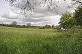 Meadow
 -
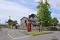 Central village roundabout
 -
 Gileston Farm
 -
 Coast at Gileston
 -
 Coastal defense wall
 -
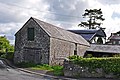 Old barn


References[edit]
- ^ “Barry Golf Club”, “Golf’s Missing Links”.
- ^ Francis, Keith A.; Gibson, William (2012), The Oxford Handbook of the British Sermon 1689–1901, Oxford University Press, ISBN 978-0198709770. Chapter 11 'Sermons in Wales in the Established Church' by John Morgan Guy
External links[edit]

This Vale of Glamorgan location article is a stub. You can help Wikipedia by expanding it. |