
Glauchau
Glauchau | ||||
|---|---|---|---|---|
 Market | ||||
Coat of arms | ||||
Location of Glauchau within Zwickau district 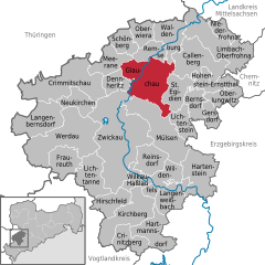 | ||||
 Glauchau  Glauchau | ||||
| Coordinates: 50°49′24″N 12°32′40″E / 50.82333°N 12.54444°E | ||||
| Country | Germany | |||
| State | Saxony | |||
| District | Zwickau | |||
| Subdivisions | 7 | |||
| Government | ||||
| • Mayor (2022–29) | Marcus Steinhart[1] (CDU) | |||
| Area | ||||
| • Total | 51.49 km2 (19.88 sq mi) | |||
| Elevation | 266 m (873 ft) | |||
| Population (2022-12-31)[2] | ||||
| • Total | 21,951 | |||
| • Density | 430/km2 (1,100/sq mi) | |||
| Time zone | UTC+01:00 (CET) | |||
| • Summer (DST) | UTC+02:00 (CEST) | |||
| Postal codes | 08371 | |||
| Dialling codes | 03763 | |||
| Vehicle registration | Z, GC | |||
| Website | www.glauchau.de | |||

Glauchau (German pronunciation: [ˈɡlaʊxaʊ] ⓘ; Upper Sorbian: Hłuchow, pronounced [ˈhwuxɔf]) is a town in the German federal state of Saxony, on the right bank of the Mulde, 7 miles north of Zwickau and 17 miles west of Chemnitz by rail (its train station is on the Dresden–Werdau line). It is part of the Zwickau district.
History[edit]
Glauchau was founded by a colony of Sorbs and Wends, and belonged to the lords of Schönburg as early as the 12th century.[3]
Sights[edit]
Some portions of the extensive old castle date from the 12th century, and the Gottesacker church contains interesting antiquarian relics.[3]
Notable people[edit]
- Johann Pfeffinger (1493–1573), theologian and Protest reformer
- Georg Agricola (1494–1555), scholar and scientist
- Samuel von Pufendorf (1632–1694), jurist, economist and historian
- Ernst Friedrich Germar (1786–1853), professor of mineralogy, entomologist and local politician
- Julius Heinrich Petermann (1801–1876), Orientalist
- Ernst Kals (1905–1979), submarine commander
- Walter Schlesinger (1908–1984), historian
- Joachim, Count of Schönburg-Glauchau (1929–1998), politician, writer, Bundestag deputy of the CDU 1990–1994
- Dieter Erler (1939–1998), footballer
- Christine Spielberg (born 1941), discus thrower
- Torsten May (born 1969), boxer
Twin towns – sister cities[edit]
 Grenay, France (1996)
 Iserlohn, Germany (1991)
 Jibou, Romania (2005)
 Lynchburg, United States (2007)
- Vermelles, France (1998)
 Zgierz, Poland (1996)
Gallery[edit]
-
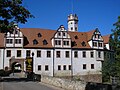 Forderglauchau Castle
 -
 Hinterglauchau Castle
 -
 A house in Leipziger street
 -
 Bismarck tower


.JPG)
References[edit]
- ^ Gewählte Bürgermeisterinnen und Bürgermeister im Freistaat Sachsen, Stand: 17. Juli 2022, Statistisches Landesamt des Freistaates Sachsen.
- ^ "Einwohnerzahlen nach Gemeinden als Excel-Arbeitsmappe" (XLS) (in German). Statistisches Landesamt des Freistaates Sachsen. 2024.
- ^ a b One or more of the preceding sentences incorporates text from a publication now in the public domain: Chisholm, Hugh, ed. (1911). "Glauchau". Encyclopædia Britannica. Vol. 12 (11th ed.). Cambridge University Press. p. 114.
- ^ "Städtepartnerschaften von Glauchau" (in German). Glauchau. Retrieved 2021-12-09.
External links[edit]
- Glauchau Notgeld (emergency banknotes) Small currency notes from Glauchau depicting the story of how the Buttermilchturm (Buttermilk tower) got its name. webgerman.com/Notgeld/
- Glauchau Notgeld (emergency banknotes) Small currency notes from Glauchau depicting the story of the Saxon Beer wars of 1731. webgerman.com/Notgeld/
| International | |
|---|---|
| National | |
| Geographic | |
| Other | |
This Zwickau location article is a stub. You can help Wikipedia by expanding it. |