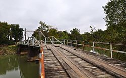
Hargrove Pivot Bridge
Appearance
Hargrove Pivot Bridge | |
 Hargrove Pivot Bridge, October 2014 | |
| Location | Carries CR 159 over the Black River, Poplar Bluff, Missouri |
|---|---|
| Coordinates | 36°38′50″N 90°18′0″W / 36.64722°N 90.30000°W |
| Area | less than one acre |
| Built | 1917 |
| Built by | Miller and Bocherding |
| Architectural style | Wichert and Warren Truss |
| NRHP reference No. | 85003234[1] |
| Added to NRHP | October 15, 1985 |
Hargrove Pivot Bridge, also known as Old Hargrove Bridge is a historic swing bridge located at Poplar Bluff, Butler County, Missouri. It crosses the Black River. It was built in 1917, and is 220 feet (67 m) long with a turning span of 100 feet (30 m). This bridge has a modified Wichert truss as its center span and a modified Warren pony truss extending on each side of the center truss. The bridge has not been turned since 1942 due to the lack of river traffic in the area.[2]: 2
It was added to the National Register of Historic Places in 1985.[1]
See also
 Transport portal
 Engineering portal
 United States portal
National Register of Historic Places portal
- National Register of Historic Places listings in Butler County, Missouri
References
- ^ a b "National Register Information System". National Register of Historic Places. National Park Service. July 9, 2010.
- ^ H. J. Eisenman (September 1984). "National Register of Historic Places Inventory Nomination Form: Hargrove Pivot Bridge" (PDF). Missouri Department of Natural Resources. Retrieved 2016-10-01.
Categories:
- Truss bridges in the United States
- Road bridges on the National Register of Historic Places in Missouri
- Bridges completed in 1917
- National Register of Historic Places in Butler County, Missouri
- 1917 establishments in Missouri
- Swing bridges in the United States
- Black River (Arkansas–Missouri)
- Southeast Missouri Registered Historic Place stubs


