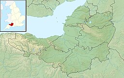
Hawkridge Reservoir
| Hawkridge Reservoir | |
|---|---|
 | |
| Location | Spaxton, Somerset, England |
| Coordinates | 51°07′09″N 3°08′02″W / 51.11917°N 3.13389°W |
| Primary inflows | Peart Water |
| Primary outflows | Cannington Brook |
| Built | 1960 |
| First flooded | 1962 |
| Surface area | 32 acres (13 ha) |
| Water volume | 864 million litres (700 acre⋅ft)[1] |
Hawkridge Reservoir is a reservoir near Spaxton, Somerset, England.
The inflow is from several streams in the Quantock Hills Area of Outstanding Natural Beauty including Peart Water, which continues below the reservoir in a northeast direction to Spaxton, where it enters the Ashford Reservoir. The distance between the two reservoirs is about 2 miles (3.2 km).[2] The Hawkridge Reservoir was built between 1960 and 1962,[3] to provide drinking water for Bridgwater which is 7 miles (11 km) to the east. It has an area of 32 acres (13 ha)[4] and can hold up to 864 million litres of water.[1] The 161 metres (528 ft) long dam is 24 metres (79 ft) wide and 27 metres (89 ft) high. 30,000 cubic meters of concrete was used in its construction.[1]
Since opening the reservoir has become home to a range of animals including; invertebrates, wildfowl and amphibians.[1] It is used for angling with catches including Rainbow Trout.[4]
References
[edit]- ^ a b c d "Hawkridge Reservoir" (PDF). Quantock Online. Retrieved 17 August 2016.
- ^ "Peart Water", Somerset Rivers, retrieved 21 August 2016
- ^ Waite, Vincent (1964). Portrait of the Quantocks. London: Robert Hale. ISBN 0-7091-1158-4.
- ^ a b "Hawkridge Reservoir". Wessex Water. Retrieved 19 November 2010.
External links
[edit] Media related to Hawkridge Reservoir at Wikimedia Commons

