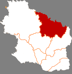
Huachi County
Huachi County
华池县 | |
|---|---|
 Huachi in Qingyang | |
 Qingyang in Gansu | |
| Coordinates: 36°27′41″N 107°59′24″E / 36.4614°N 107.9900°E | |
| Country | People's Republic of China |
| Province | Gansu |
| Prefecture-level city | Qingyang |
| Area | |
• Total | 3,791 km2 (1,464 sq mi) |
| Highest elevation | 1,780 m (5,840 ft) |
| Lowest elevation | 1,100 m (3,600 ft) |
| Population (2018) | |
• Total | 138,680 |
| • Density | 37/km2 (95/sq mi) |
| Time zone | UTC+8 (China Standard) |
| Postal code | 745600 |
| Website | www |
Huachi County (simplified Chinese: 华池县; traditional Chinese: 華池縣; pinyin: Huáchí Xiàn) is a county in the east of Gansu province, China, bordering Shaanxi province to the north and northeast. It is under the administration of the prefecture-level city of Qingyang. Its postal code is 745600, and its population in 2018 was 138,680 people. Huachi has a low population density and is one of the poorer counties of China, partly because of the dry climate.[1]
Parts of the Qin Great Wall run through Huachi. Huachi was established as a county during the Western Wei dynasty. During the Five Dynasties period it was abolished, becoming part of neighbouring counties. In 1934 it was re-established. During the first encirclement campaign against the Shaanxi–Gansu Soviet it was home to the Nanliang communist base.[1]
Huachi's important agricultural produce includes white melon seeds, daylily, wood ear mushroom and millets.[1]
Administrative divisions
Huachi County is divided to 6 towns and 9 townships.[2]
- Towns
|
|
- Townships
|
|
Climate
| Climate data for Huachi (1981−2010) | |||||||||||||
|---|---|---|---|---|---|---|---|---|---|---|---|---|---|
| Month | Jan | Feb | Mar | Apr | May | Jun | Jul | Aug | Sep | Oct | Nov | Dec | Year |
| Record high °C (°F) | 14.1 (57.4) |
19.4 (66.9) |
27.0 (80.6) |
34.5 (94.1) |
34.5 (94.1) |
37.7 (99.9) |
38.0 (100.4) |
34.2 (93.6) |
34.8 (94.6) |
27.2 (81.0) |
23.0 (73.4) |
15.6 (60.1) |
38.0 (100.4) |
| Mean daily maximum °C (°F) | 1.9 (35.4) |
5.2 (41.4) |
10.9 (51.6) |
18.4 (65.1) |
23.6 (74.5) |
27.4 (81.3) |
28.7 (83.7) |
26.7 (80.1) |
21.8 (71.2) |
15.8 (60.4) |
9.4 (48.9) |
3.4 (38.1) |
16.1 (61.0) |
| Daily mean °C (°F) | −6.4 (20.5) |
−2.5 (27.5) |
3.4 (38.1) |
10.5 (50.9) |
16.1 (61.0) |
20.2 (68.4) |
22.2 (72.0) |
20.3 (68.5) |
15.2 (59.4) |
8.5 (47.3) |
1.2 (34.2) |
−4.7 (23.5) |
8.7 (47.6) |
| Mean daily minimum °C (°F) | −12.1 (10.2) |
−8.0 (17.6) |
−2.3 (27.9) |
3.6 (38.5) |
8.9 (48.0) |
13.4 (56.1) |
16.6 (61.9) |
15.5 (59.9) |
10.5 (50.9) |
3.6 (38.5) |
−4.0 (24.8) |
−10.1 (13.8) |
3.0 (37.3) |
| Record low °C (°F) | −23.1 (−9.6) |
−21.0 (−5.8) |
−15.9 (3.4) |
−7.8 (18.0) |
−2.7 (27.1) |
4.6 (40.3) |
8.8 (47.8) |
5.2 (41.4) |
−0.9 (30.4) |
−9.4 (15.1) |
−16.1 (3.0) |
−26.5 (−15.7) |
−26.5 (−15.7) |
| Average precipitation mm (inches) | 3.2 (0.13) |
5.1 (0.20) |
13.7 (0.54) |
23.7 (0.93) |
41.9 (1.65) |
56.4 (2.22) |
98.0 (3.86) |
115.4 (4.54) |
66.7 (2.63) |
32.6 (1.28) |
11.1 (0.44) |
2.8 (0.11) |
470.6 (18.53) |
| Average relative humidity (%) | 58 | 56 | 55 | 50 | 53 | 59 | 68 | 74 | 76 | 74 | 66 | 60 | 62 |
| Source: China Meteorological Data Service Center[3] | |||||||||||||
See also
References
- ^ a b c "庆阳市华池县情简介" [Brief Introduction of Huachi County, Qingyang City] (in Chinese).
{{cite web}}: CS1 maint: url-status (link) - ^ "统计用区划代码 www.stats.gov.cn" (in Chinese). XZQH. Retrieved 2020-12-27.
- ^ 中国地面气候标准值月值(1981-2010) (in Simplified Chinese). China Meteorological Data Service Center. Retrieved 24 November 2022.
External links
