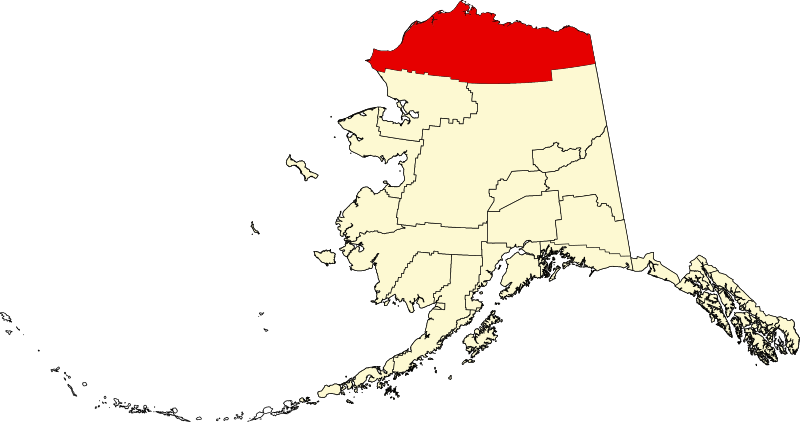
File:Map of Alaska highlighting North Slope Borough.svg
Appearance

Size of this PNG preview of this SVG file: 800 × 423 pixels. Other resolutions: 320 × 169 pixels | 640 × 338 pixels | 1,024 × 541 pixels | 1,280 × 677 pixels | 2,560 × 1,353 pixels | 1,470 × 777 pixels.
Original file (SVG file, nominally 1,470 × 777 pixels, file size: 644 KB)
File history
Click on a date/time to view the file as it appeared at that time.
| Date/Time | Thumbnail | Dimensions | User | Comment | |
|---|---|---|---|---|---|
| current | 20:11, 25 June 2024 |  | 1,470 × 777 (644 KB) | Nux | uniform colors with good contrast |
| 23:16, 17 June 2024 |  | 1,470 × 777 (338 KB) | Nux | fix rendering (remove clipping) | |
| 23:13, 17 June 2024 |  | 1,470 × 777 (338 KB) | Nux | fix rendering (remove clipping) | |
| 19:28, 5 March 2006 |  | 1,470 × 777 (338 KB) | David Benbennick | {{subst:User:Dbenbenn/clm|county=North Slope Borough|state=Alaska|type=borough and census area}} |
File usage
More than 100 pages use this file. The following list shows the first 100 pages that use this file only. A full list is available.
- Adventure Creek
- Agiak Lagoon
- Akporvik Hill
- Akulik Creek
- Alpine, Alaska
- Alpine Airstrip
- Aluakpak
- Amatusuk Hills
- Amo Creek
- Anaktuvuk Pass
- Anaktuvuk Pass, Alaska
- Anxiety Point
- Archimedes Ridge
- Arey Island
- Arey Lagoon
- Atanik
- Atigun Pass
- Atqasuk, Alaska
- Avingak Creek
- Awuna River
- Canning River (Alaska)
- Cape Beaufort
- Cape Lisburne
- Cape Sabine (Alaska)
- Cape Sabine DEW Line Station
- Cape Thompson
- Chariot, Alaska
- Coleen River
- De Long Mountains
- Deadfall Creek
- Deadhorse, Alaska
- Disappointment Creek (Utukok River tributary)
- Driftwood Creek
- Elusive Creek
- Epizetka River
- Eskimo Hill
- Etivluk River
- Franklin Mountains (Alaska)
- Gull Island (Prudhoe Bay)
- Icy Cape
- Itkillik River
- Ivishak River
- Iñupiat
- KBRW-FM
- KBRW (AM)
- Kadleroshilik Pingo
- Kaktovik, Alaska
- Kaktovik numerals
- Kasegaluk Lagoon
- Kivalina River
- Kokolik River
- Kongakut River
- Kugrua Bay
- Kuk River
- Kukpowruk River
- Kukpuk River
- Kuparuk River
- Lisburne Peninsula
- List of boroughs and census areas in Alaska
- Meade River
- Meat Mountain
- Mollie Beattie Wilderness
- Mount Chamberlin (Alaska)
- Mount Hubley (Alaska)
- Mount Isto
- Mount Michelson (Brooks Range)
- National Register of Historic Places listings in North Slope Borough, Alaska
- Native Village of Barrow Inupiat Traditional Government
- Nigu River
- North Fork Koyukuk River
- North Slope Borough, Alaska
- Nuiqsut, Alaska
- Omicron Hill
- Peard Bay
- Pitmegea River
- Point Franklin
- Point Hope, Alaska
- Point Hope (cape)
- Point Hope Airport
- Point Lay, Alaska
- Poko Mountain
- Prudhoe Bay, Alaska
- Sagavanirktok River
- Sagwon, Alaska
- Seahorse Islands
- Tarn Oil Field
- Thetis Mound
- Ugnu–Kuparuk Airport
- Umiat, Alaska
- Utkeagvik Church Manse
- Utqiagvik, Alaska
- Utukok River
- Wainwright, Alaska
- Western Arctic National Parklands
- Wevok, Alaska
- Wind River (Yukon–Koyukuk Census Area, Alaska)
- Wulik River
- User:Nyttend/County templates/AK
- Wikipedia:WikiProject Alaska
- Template:NorthSlopeAK-geo-stub
View more links to this file.
Global file usage
The following other wikis use this file:
- Usage on ar.wikipedia.org
- Usage on azb.wikipedia.org
- Usage on az.wikipedia.org
- Usage on bpy.wikipedia.org
- Usage on ca.wikipedia.org
- Usage on ceb.wikipedia.org
- Usage on ce.wikipedia.org
- Usage on cy.wikipedia.org
- Usage on de.wikipedia.org
- Usage on es.wikipedia.org
- Usage on fa.wikipedia.org
- Usage on fi.wikipedia.org
- Usage on fo.wikipedia.org
- Usage on fr.wikipedia.org
View more global usage of this file.
