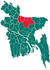
Islampur Upazila
Islampur
ইসলামপুর | |
|---|---|
| Coordinates: 25°5′N 89°47.5′E / 25.083°N 89.7917°E | |
| Country | |
| Division | Mymensingh Division |
| District | Jamalpur District |
| Area | |
| • Total | 343.02 km2 (132.44 sq mi) |
| Population (2011) | |
| • Total | 298,429 |
| • Density | 870/km2 (2,300/sq mi) |
| Time zone | UTC+6 (BST) |
| Postal code | 2020 |
| Website | islampur |
Islampur (Template:Lang-bn) is an Upazila of Jamalpur District[1] in the Division of Mymensingh, Bangladesh.
Geography
Islampur is located at 25°05′00″N 89°47′30″E / 25.0833°N 89.7917°E. It has 51671 households and total area 343.02 km2.
Demographics
| Year | Pop. (000) | ±% |
|---|---|---|
| 1981 | 157 | — |
| 1991 | 268 | +70.7% |
| 2001 | 289 | +7.8% |
| 2011 | 298 | +3.1% |
| Source: Bangladesh Bureau of Statistics[2] | ||
According to the 2011 Bangladesh census, Islampur Upazila had 74,963 households and a population of 298,429, 12.9% of whom lived in urban areas. 12.2% of the population was under the age of 5. The literacy rate (age 7 and over) was 30.1%, compared to the national average of 51.8%.[3][4]
Points of interest
1. Jamuna River Bank (Guthail Bazar) 2. Laochapra Obokas Kendro (Laochapra, Boksigang) 3. Bambrapurto river side, Ambaria, Islampur 4. Debraipach Bridge
Administration
Islampur Upazila is divided into Islampur Municipality and 12 union parishads: Belghacha, Char Gualini, Char Putimari, Chinaduli, Gaibandha, Gualerchar, Islampur, Kulkandi, Noapara, Palabandha, Partharshi, and Shapdari. The union parishads are subdivided into 58 mauzas and 130 villages.[2]
Education
1. Saverchar V.S.A Darusunnah Dakhil Madrasah
2. Guthail Sinior Alim Madrasha
3. Al Hera Ideal Academy
4. Ghaibandha Shurujjhan High School
5. Shajeda Mahmud High School
6. Morakandi Nosimon Nesa Dakhil Madrasha
7. Chinaduli Fazil Madrasha
8. Kulkandi shamsunnahar High School
9. Islampur Nekjahan Pilot Model High school
10. Islampur Gov. University College
11. Islampur JJKM Girls School and College
12. Islampur High School
13. Kulkandi ABS High School
14. Surjomukhi Bidapith School
15. Islampur M.A. Samad Parvez Mohila Degree College
16. Chinaduly High School
17. Guthail High School and College
See also
References
- ^ Sayed Abdullah Al Mamun Chowdhury (2012), "Islampur Upazila", in Sirajul Islam and Ahmed A. Jamal (ed.), Banglapedia: National Encyclopedia of Bangladesh (Second ed.), Asiatic Society of Bangladesh
- ^ a b "District Statistics 2011: Jamalpur" (PDF). Bangladesh Bureau of Statistics. Archived from the original (PDF) on 13 November 2014. Retrieved 14 July 2014.
- ^ "Community Report: Jamalpur" (PDF). Population & Housing Census 2011. Bangladesh Bureau of Statistics. Retrieved 15 August 2018.
- ^ "Population and Housing Census 2011: Bangladesh at a Glance" (PDF). Bangladesh Bureau of Statistics. Archived from the original (PDF) on 28 July 2014. Retrieved 21 July 2014.


