
Jebel Jais
| Jebel Jais | |
|---|---|
| Jabal Jays | |
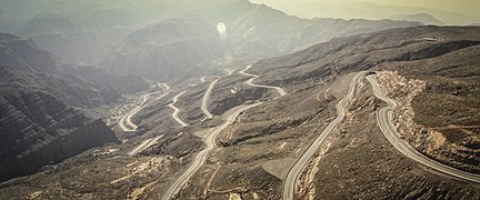
 The road leading to the top of Jebel Jais in Ras Al-Khaimah | |
| Highest point | |
| Elevation | 1,934 m (6,345 ft)[1] |
| Prominence | 431 m (1,414 ft) |
| Isolation | 4.92 km (3.06 mi) |
| Coordinates | 25°57′11″N 56°11′03″E / 25.95306°N 56.18417°E |
| Naming | |
| Native name | جَبَل جَيْس (Arabic) |
| Geography | |
 Jebel Jais Location of Jebel Jais  Jebel Jais Jebel Jais (Oman)  Jebel Jais Jebel Jais (West and Central Asia) | |
| Countries | United Arab Emirates and Oman |
| Parent range | Al Hajar Mountains |
Jebel Jais (Arabic: جبل جيس, romanized: Jabal Jays) is a mountain of the North-Western Hajar range in the Musandam Governorate of Oman and also in Ras Al Khaimah, United Arab Emirates. The summit has an elevation of 1,934 m (6,345 ft).[1] The summit is located on the Omani side, but a high point west of this peak is considered the highest point in the United Arab Emirates, at 1,892 m (6,207 ft) above sea level, and with around 10m of prominence.[citation needed] Since the summit is on the Omani side, Jabal ar Raḩraḩ, at , is the highest peak in the UAE, with significant prominence.[2]
Infrastructure[edit]
On the Omani side, the mountain is largely underdeveloped, inaccessible, and far from any development, however, on the United Arab Emirates side there has been a lot of development in recent years. A 36 km (22 mi) road has been built, which hairpins most of the way up the mountain on the United Arab Emirates side.[3] Near the top of the road, there are parking places, food providers, toilets and a viewing platform. After a security checkpoint, the road continues up a few kilometers further to the world's longest zip-line and an Etisalat cell tower, as well as a large flat area used for outdoor shows and parking. New buildings are also being built along this road section, for use of the zip-line operating company. This section was completed towards the end of 2017; however, it remains closed to the public, by motorized vehicles, as of December 2019.[4] A private brick road then continues further up, to Sheikh Saud Bin Saqr Al Qasimi's palace, which is situated near the UAE's highest point. The summit is then accessible by hiking, a short distance after the palace perimeter fence.
The road was completed by September 2019.[5]
UAE Tour Road Cycling Race[edit]
The mountain, and the highway to its peak, feature prominently in the UAE Tour, an annual road cycling stage race, first held in 2019 as part of the UCI World Tour. Due to the difficulty of the long, steep climb, the stage that finishes here is usually considered the queen stage of the entire UAE Tour. Previous winners of the Jebel Jais stage include Grand Tour and UAE Tour winners Primož Roglič and Tadej Pogačar.[6][7]
Jebel Jais zip-line[edit]
The world's longest zip-line opened on the mountain in February 2018. It is 2,832 m (9,291 ft) long, and users travel at speeds of up to 150 km/h (93 mph),[8][9] There are, or have been, plans in place to build a hotel, cable car, paragliding launch ramp, golf course and ski slope following the opening of the road. The cost is around $98 to $122 or €89 to €111.[10]
Climate[edit]
The temperature of Ras Al Khaimah tends to be lower than in other parts of the country. Temperatures as low as -5°C[11] have been measured at the top of the mountain in winter. The temperatures at the highest elevations on the mountain tend to be lower than other parts of the United Arab Emirates, by about ten degrees, except for spots such as the mountains of Hafeet,[12] Yibir, Yanas and Al-Heben.[13]
| Climate data for Jebel Jais (2003–2021) | |||||||||||||
|---|---|---|---|---|---|---|---|---|---|---|---|---|---|
| Month | Jan | Feb | Mar | Apr | May | Jun | Jul | Aug | Sep | Oct | Nov | Dec | Year |
| Record high °C (°F) | 21.1 (70.0) |
22.2 (72.0) |
27.7 (81.9) |
29.0 (84.2) |
34.1 (93.4) |
36.5 (97.7) |
35.0 (95.0) |
34.9 (94.8) |
33.1 (91.6) |
29.0 (84.2) |
23.7 (74.7) |
23.0 (73.4) |
36.5 (97.7) |
| Mean daily maximum °C (°F) | 11.2 (52.2) |
13.2 (55.8) |
17.1 (62.8) |
21.6 (70.9) |
26.6 (79.9) |
30.2 (86.4) |
30.5 (86.9) |
29.8 (85.6) |
27.6 (81.7) |
23.1 (73.6) |
17.0 (62.6) |
13.3 (55.9) |
21.8 (71.2) |
| Daily mean °C (°F) | 8.8 (47.8) |
10.7 (51.3) |
14.4 (57.9) |
18.9 (66.0) |
23.7 (74.7) |
27.4 (81.3) |
27.6 (81.7) |
27.0 (80.6) |
24.8 (76.6) |
20.2 (68.4) |
14.3 (57.7) |
10.7 (51.3) |
19.0 (66.3) |
| Mean daily minimum °C (°F) | 6.4 (43.5) |
8.1 (46.6) |
11.7 (53.1) |
16.2 (61.2) |
21.1 (70.0) |
24.7 (76.5) |
24.9 (76.8) |
24.5 (76.1) |
22.3 (72.1) |
17.8 (64.0) |
11.9 (53.4) |
8.3 (46.9) |
16.5 (61.7) |
| Record low °C (°F) | −0.3 (31.5) |
−5.7 (21.7) |
1.2 (34.2) |
5.0 (41.0) |
9.0 (48.2) |
16.4 (61.5) |
17.8 (64.0) |
17.8 (64.0) |
16.5 (61.7) |
11.2 (52.2) |
4.1 (39.4) |
−0.7 (30.7) |
−5.7 (21.7) |
| Average rainfall mm (inches) | 29.2 (1.15) |
15.1 (0.59) |
32.4 (1.28) |
15.3 (0.60) |
0.4 (0.02) |
0.0 (0.0) |
0.3 (0.01) |
0.6 (0.02) |
0.2 (0.01) |
5.8 (0.23) |
14.5 (0.57) |
15.2 (0.60) |
129 (5.08) |
| Average relative humidity (%) | 51 | 44 | 35 | 31 | 27 | 24 | 31 | 32 | 28 | 34 | 48 | 51 | 36 |
| Source: National Center of Meteorology[14] | |||||||||||||
Snow fall[edit]
In January 2009 there was snow on Jebel Jais.[15] This was only the second time snow had been reported in the history of United Arab Emirates, previously having only been seen in 2004.[16] There was less on this occasion. In February 2017 it snowed again on Jebel Jais and the temperatures fell down-to -5 degrees Celsius.[11] In January 2020 a mix of snow and hail covered the mountain with the temperature dropping below zero degrees.[17]
Gallery[edit]
-
-
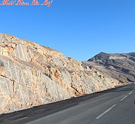
 View from the Jabal Jais Road
 -
-
-
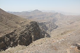
 Jebel Jais Mountain Ranges as viewed from Ras Al Khaimah


.jpg)
.jpg)

See also[edit]
- Geography of Oman
- Geography of the United Arab Emirates
- List of countries by highest point
- List of tourist attractions in the United Arab Emirates
- Wadi Bih
- Wildlife of Oman
- Wildlife of the United Arab Emirates
- Ras Al Khaimah
References[edit]
- ^ a b "Jebel Jais". Jebel Jais Ras Al Khaimah. Retrieved 5 December 2017.
- ^ "Jabal ar Raḩraḩ, Ra's al Khaymah, United Arab Emirates". GeoNames.org. Retrieved 2023-04-23.
- ^ "Scaling New Heights: RAK Jebel Jais Road Development". Al Marwan Heavy Machinery. 2023-07-26. Retrieved 2023-10-14.
- ^ "Popular Jebel Jais mountain road closed". Expat Media. 2019-12-19. Retrieved 2023-10-14.
- ^ Morgan, James. "UAE: Jebel Jais Mountain Road to complete in 2019 | ConstructionWeekOnline.com". www.constructionweekonline.com. Retrieved 2018-06-27.
- ^ "UAE Tour 2019: Leader Roglic Sprints to Queen Stage Win | CyclingStage.com". cyclingstage.com/uae-tour-2019/stage-6-results-uae-2019/.
- ^ Ryan, Barry. "UAE Tour: Tadej Pogacar wins stage 4 on Jebel Jais mountain finish | CyclingStage.com". cyclingnews.com/races/uae-tour-2022/stage-4/results//.
- ^ Rachel Swatman. "This is what it's like to fly along the world's longest zip line at 93 mph". Guinness World Records.
- ^ CNN. "The world's longest zip line in action - CNN Video". CNN news.
{{cite news}}:|last1=has generic name (help) - ^ "Great driving roads: Jebel Jais Mountain Road, Ras Al Khaimah | The National". Retrieved 2015-08-16.
- ^ a b Report, Gulf News Web (3 February 2017). "Look: It's -5°C and it's snowing in the UAE". GulfNews. Retrieved 21 February 2017.
- ^ Al Serkal, Mariam M. (2019-03-10). "UAE to see cold days ahead, temperatures drop to 2.6°C". Gulf News. Retrieved 2019-03-17.
- ^ Al Serkal, Mariam M. (2019-02-28). "UAE to get 5 days of rain and "significant drop in temperature"". Gulf News. Retrieved 2019-03-17.
- ^ "Climate Yearly Report". National Center of Meteorology. Retrieved January 31, 2023.
- ^ Staff (2016-07-28). "This place is coolest in UAE". Emirates24|7. Retrieved 2018-09-27.
- ^ "This is the frozen north ... of the UAE". The National. Retrieved 2018-09-27.
- ^ "Photos: Snow covers UAE's Jebel Jais as temperature drops below 0°C". Khaleej Times. Retrieved 2020-01-19.
External links[edit]
- (in English) Is this the right way to the top?, The National, February 21, 2009.
- Jebel Jais, Ras Al Khaimah, UAE | جبل جيس، إمارة رأس الخيمة، الإمارات (YouTube)
- Hiking: The Highest Points in the UAE
Hills and mountains on the Arabian Peninsula | |
|---|---|
Note: Mountains are sorted in alphabetical order, unless where it concerns ranges. The highest confirmed mountains in each country are indicated with 'HP', and those with the highest peak are indicated with 'HP', bearing in mind that in the UAE, the highest mountain and the mountain with the highest peak are different. Outcrops are indicated with 'OC', and outliers with 'OL', and anticlines with 'AC'. Volcanoes are indicated with 'V', volcanic craters with 'VC', lava fields with 'LF', and volcanic fields with 'VF'.
Other notes:
|
.jpg)


