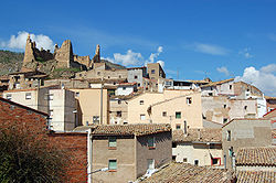
Jarque
Appearance
Jarque | |
|---|---|
municipality | |
 | |
| Country | Spain |
| Autonomous community | Aragon |
| Province | Zaragoza |
| Municipality | Jarque |
| Area | |
| • Total | 43 km2 (17 sq mi) |
| Population (2004) | |
| • Total | 556 |
| • Density | 12.9/km2 (33/sq mi) |
| Time zone | UTC+1 (CET) |
| • Summer (DST) | UTC+2 (CEST) |
Jarque is a municipality located in the Aranda Comarca, province of Zaragoza, Aragon, Spain. According to the 2004 census (INE), the municipality has a population of 556 inhabitants.
The town is also known as Jarque de Moncayo, despite its location at the feet of the Sierra de la Virgen, another range of the Iberian System. The Moncayo Massif is visible in the distance to the north of the town.
Lua error in Module:Location_map at line 526: Unable to find the specified location map definition: "Module:Location map/data/Iberia relief" does not exist.
External links
Wikimedia Commons has media related to Jarque de Moncayo.
41°34′N 1°40′W / 41.567°N 1.667°W


