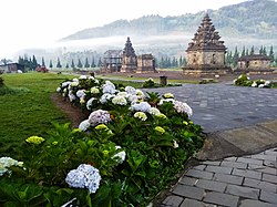
Banjarnegara Regency
Banjarnegara Regency
Kabupaten Banjarnegara | |
|---|---|
 | |
| Motto: Manunggaling Swara Tumataning Praja | |
| Coordinates: 7°23′46″S 109°45′27″E / 7.39611°S 109.75750°E | |
| Country | Indonesia |
| Province | Central Java |
| Capital | Banjarnegara |
| Area | |
• Total | 1,069.73 km2 (413.03 sq mi) |
| Population (mid 2023 estimate) | |
• Total | 1,047,226 |
| • Density | 980/km2 (2,500/sq mi) |
| [1] | |
| Time zone | UTC+7 (WIB) |
| Area code | +62 286 |
| Website | banjarnegarakab.go.id |
Banjarnegara (Javanese: ꦧꦚ꧀ꦗꦂꦤꦼꦒꦫ) is an inland regency (Indonesian: kabupaten) in the southwestern part of Central Java province in Indonesia. The regency covers an area of 1,069.73 km2, and it had a population of 868,913 at the 2010 Census[2] and 1,017,767 at the 2020 Census;[3] the official estimate as at mid 2023 was 1,047,226 (comprising 531,338 males and 515,888 females).[1] Its capital is the town of Banjarnegara.
Administrative Districts
[edit]Banjarnegara Regency comprises twenty districts (kecamatan), tabulated below with their areas and their populations at the 2010 Census[2] and the 2020 Census,[3] together with the official estimates as at mid 2023.[1] The table also includes the location of the district administrative centres, the number of administrative villages in each district (totalling 266 rural desa and 12 urban kelurahan), and its postal code.
| Kode Wilayah |
Name of District (kecamatan) |
Area in km2 |
Pop'n 2010 Census |
Pop'n 2020 Census |
Pop'n mid 2023 estimate |
Admin centre |
No. of villages |
Post code |
|---|---|---|---|---|---|---|---|---|
| 33.04.01 | Susukan | 52.66 | 52,160 | 62,706 | 64,997 | Susukan | 15 | 53475 |
| 33.04.02 | Purwareja Klampok | 21.87 | 40,064 | 47,657 | 49,246 | Klampok | 8 | 53474 |
| 33.04.03 | Mandiraja | 52.62 | 63,679 | 78,090 | 81,411 | Mandiraja Kulon | 16 | 53473 |
| 33.04.04 | Purwanegara | 73.87 | 66,994 | 81,764 | 85,123 | Purwanegara | 13 | 53472 |
| 33.04.05 | Bawang | 55.21 | 53,321 | 63,335 | 65,420 | Mantrianom | 18 | 53471 |
| 33.04.06 | Banjarnegara (town) |
26.24 | 62,962 | 69,543 | 70,332 | Kuta Banjarnegara | 13 (a) | 53411 - 53418 |
| 33.04.20 | Pagedongan | 80.55 | 33,832 | 41,736 | 43,586 | Pagedongan | 9 | 53418 |
| 33.04.07 | Sigaluh | 39.56 | 28,107 | 31,993 | 32,640 | Gembongan | 15 (b) | 53481 |
| 33.04.08 | Madukara | 48.20 | 40,074 | 45,952 | 46,982 | Kutayasa | 20 (c) | 53482 |
| 33.04.09 | Banjarmangu | 46.36 | 39,799 | 46,301 | 47,537 | Banjarmangu | 17 | 53452 |
| 33.04.10 | Wanadadi | 28.27 | 26,538 | 33,553 | 34,520 | Wanadadi | 11 | 53461 |
| 33.04.11 | Rakit | 32.45 | 45,998 | 53,686 | 55,171 | Rakit | 11 | 53463 |
| 33.04.12 | Punggelan | 102.84 | 71,658 | 86,419 | 89,659 | Punggelan | 17 | 53462 |
| 33.04.13 | Karangkobar | 39.07 | 27,703 | 31,599 | 32,257 | Leksana | 13 | 53453 |
| 33.04.14 | Pagentan | 46.19 | 34,028 | 38,221 | 38,844 | Pagentan | 16 | 53455 |
| 33.04.15 | Pejawaran | 52.25 | 39,571 | 44,571 | 45,334 | Penusupan | 17 | 53454 |
| 33.04.16 | Batur | 47.17 | 36,388 | 40,826 | 41,477 | Batur | 8 | 53456 |
| 33.04.17 | Wanayasa | 82.01 | 44,372 | 50,533 | 51,562 | Wanayasa | 17 | 53457 |
| 33.04.18 | Kalibening | 83.78 | 39,724 | 46,156 | 47,636 | Kalibening | 16 | 53458 |
| 33.04.19 | Pandanarum | 58.56 | 19,841 | 22,926 | 23,492 | Beji | 8 | 53459 |
| Totals | 1,069.73 | 868,913 | 1,017,767 | 1,047,226 | Banjarnegara | 278 |
Notes: (a) comprising 9 urban keluraham (Argasoka, Karangtengah, Krandegan, Kutabanjarnegara, Parakancanggah, Semampir, Semarang, Sokanandi and Wangon) and 4 desa.
(b) including one kelurahan (Kalibenda). (c) including 2 kelurahan (Kenteng and Rejasa).
Transport
[edit]There is a bus terminal called Mandiraja Terminal in this regency.
Agriculture
[edit]References
[edit]


