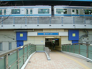
Kaminagaya Station
Appearance
 Entrance No.2 | ||||||||||||||||
| General information | ||||||||||||||||
| Location | Maruyamadai 1-1-1, Kōnan, Yokohama, Kanagawa (横浜市港南区丸山台一丁目1-1) Japan | |||||||||||||||
| Operated by | ||||||||||||||||
| Line(s) | ||||||||||||||||
| Other information | ||||||||||||||||
| Station code | B09 | |||||||||||||||
| History | ||||||||||||||||
| Opened | September 4, 1976 | |||||||||||||||
| Passengers | ||||||||||||||||
| 2008 | 18,783 daily | |||||||||||||||
| Services | ||||||||||||||||
| ||||||||||||||||
Kaminagaya Station (上永谷駅, Kaminagaya-eki) is an above-ground metro station located in Kōnan-ku, Yokohama, Kanagawa, Japan operated by the Yokohama Municipal Subway’s Blue Line (Line 1). It is 11.0 kilometers from the terminus of the Blue Line at Shōnandai Station.
History
Kaminagaya Station was opened on September 4, 1976, initially as a terminal station the Blue Line. The line was extended on to Maioka Station on March 14, 1985. Platform screen doors were installed in September 2007.
Lines
Station layout
Kaminagaya Station is an elevated station with two above-ground island platforms serving four tracks. The platforms are on the third floor, with the exit gates and station building below.
Platforms
-
Ticket gates
-
Platform
References
- Harris, Ken and Clarke, Jackie. Jane's World Railways 2008-2009. Jane's Information Group (2008). ISBN 0-7106-2861-7
Wikimedia Commons has media related to Kaminagaya Station.
External links
- Kaminagaya Station (Blue Line) (in Japanese)


