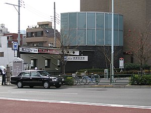
Kiyosumi-shirakawa Station
Z11 E14 Kiyosumi-shirakawa Station 清澄白河駅 | |||||||||||||||||||||
|---|---|---|---|---|---|---|---|---|---|---|---|---|---|---|---|---|---|---|---|---|---|
 Station entrance | |||||||||||||||||||||
| General information | |||||||||||||||||||||
| Location | 1-6-13 Shirakawa (Hanzōmon Line) 7-14 Shirakawa 1-chome (Ōedo Line) Kōtō, Tokyo Japan | ||||||||||||||||||||
| Operated by | |||||||||||||||||||||
| Line(s) | Z Hanzōmon Line E Ōedo Line | ||||||||||||||||||||
| Platforms | 1 island platform (Hanzōmon Line) 2 island platforms (Ōedo Line) | ||||||||||||||||||||
| Tracks | 2 (Hanzōmon Line), 3 (Ōedo Line) | ||||||||||||||||||||
| Construction | |||||||||||||||||||||
| Structure type | Underground | ||||||||||||||||||||
| Other information | |||||||||||||||||||||
| Station code | E-14 (Ōedo Line) Z-11 (Hanzōmon Line) | ||||||||||||||||||||
| History | |||||||||||||||||||||
| Opened | 12 December 2000 | ||||||||||||||||||||
| Services | |||||||||||||||||||||
| |||||||||||||||||||||
| |||||||||||||||||||||
Kiyosumi-shirakawa Station (清澄白河駅, Kiyosumi-shirakawa-eki) is a subway station on the Tokyo Metro Hanzōmon Line and the Toei Ōedo Line in Koto, Tokyo, Japan, jointly operated by the two Tokyo subway operators Tokyo Metro, Toei Subway.
Some trains on both lines terminate and originate at this station.
Station layout
[edit]Toei platforms
[edit]The Toei section of the station is composed of two island platforms serving three tracks.
| 1/2 | E Ōedo Line | for Ryōgoku, Iidabashi, and Tochōmae |
| 3/4 | E Ōedo Line | for Daimon and Roppongi |
Platforms 2 and 3 serve the same track, with some trains terminating and starting at this platform.
-
Oedo Line platforms
-
Oedo Line middle track turnout and crossovers outside Kiyosumi-shirakawa station, 2008
Tokyo Metro platforms
[edit]The Tokyo Metro section of the station is a single island platform serving two tracks.
| 1 | Z Hanzōmon Line | for Ōtemachi and Shibuya DT Den-en-toshi Line for Chūō-Rinkan |
| 2 | Z Hanzōmon Line | for Kinshichō and Oshiage TS Tobu Skytree Line for Tōbu-Dōbutsu-Kōen TI Tobu Isesaki Line for Kuki TN Tōbu Nikkō Line for Minami-Kurihashi |
-
Hanzomon Line platforms
-
Hanzomon Line track crossover outside Kiyosumi-shirakawa station, 2009
History
[edit]The Toei Ōedo Line station opened on 12 December 2000. The Hanzōmon Line station opened on 19 March 2003.[citation needed]
The station facilities of the Hanzōmon Line were inherited by Tokyo Metro after the privatization of the Teito Rapid Transit Authority (TRTA) in 2004.[1]
Passenger statistics
[edit]In fiscal 2013, the Tokyo Metro station was the least used on the Hanzōmon line and the 78th-busiest on the Tokyo Metro network as a whole with an average of 47,192 passengers daily.[2] Over the same fiscal year, the Toei station was used by an average of 17,430 passengers daily (boarding passengers only).[3] The passenger statistics for the Tokyo Metro station in previous years are as shown below.
| Fiscal year | Daily average |
|---|---|
| 2011 | 41,938[4] |
| 2012 | 45,263[5] |
| 2013 | 47,192[2] |
References
[edit]- ^ "「営団地下鉄」から「東京メトロ」へ" [From "Teito Rapid Transit Authority" to "Tokyo Metro"]. Tokyo Metro Online. 8 July 2006. Archived from the original on 16 May 2012. Retrieved 29 May 2022.
- ^ a b 各駅の乗降人員ランキング [Station usage ranking] (in Japanese). Tokyo Metro. Retrieved 10 September 2014.
- ^ 各駅乗降人員一覧 [Station usage figures] (in Japanese). Tokyo Metropolitan Bureau of Transportation. Retrieved 10 September 2014.
- ^ 駅別乗降人員順位表(2011年度1日平均) [Station passenger figures (Fiscal 2011)] (in Japanese). Japan: Tokyo Metro. Retrieved 10 September 2014.
- ^ 各駅の乗降人員ランキング (2012年) [Station usage ranking (2012)] (in Japanese). Tokyo Metro. Retrieved 10 September 2014.
External links
[edit]- Kiyosumi-shirakawa Station information (Tokyo Metro) (in Japanese)
- Kiyosumi-shirakawa Station information (Toei) (in Japanese)


