
Kohila Parish
Kohila Parish
Kohila vald | |
|---|---|
 Kohila manor | |
 Flag  Coat of arms | |
 Kohila Parish within Rapla County. | |
| Country | |
| County | |
| Administrative centre | Kohila |
| Government | |
| • Mayor | Andrus Saare (Union of Pro Patria and Res Publica) |
| Area | |
| • Total | 230.20 km2 (88.88 sq mi) |
| Population (01.01.2009) | |
| • Total | 5,925 |
| • Density | 26/km2 (67/sq mi) |
| ISO 3166 code | EE-317 |
| Website | www.kohila.ee |
Kohila Parish (Estonian: Kohila vald) is the northernmost municipality of Rapla County, Estonia. It has a population of 5,925 (as of 1 January 2009) and an area of 230.20 km (143.04 mi).[1]
Settlements[edit]
- Borough
- Small boroughs
- Villages
Aandu - Adila - Angerja - Hageri - Kadaka - Lohu - Loone - Lümandu - Masti - Mälivere - Pahkla - Pihali - Pukamäe - Põikma - Rabivere - Rootsi - Salutaguse - Sutlema - Urge - Vana-Aespa - Vilivere
The administrative centre of Kohila Parish is Kohila borough (alev) with population 3,505 (as of 1 January 2006).[2] It is situated 33 km south to Estonia's capital, Tallinn and 22 km north to county's administrative center Rapla.
Religion[edit]
Religion in Kohila Parish (2021) [1]
Local government[edit]
Current chairman of the council (volikogu esimees) is Margus Miller from the electoral coalition "Minu Kohila".[3]
Current mayor (vallavanem) is Andrus Saare[4] from the Union of Pro Patria and Res Publica.
Gallery[edit]
-
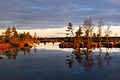 Lake Kaselaug in Rabivere nature reserve
 -
 Ruins of Sutlema manor distillery
 -
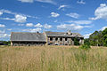
 Tohisoo manor main building
 -
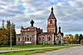 Kohila church
 -
 Hageri church
 -
 Baptist Church of Kohila
 -
 Ruins of Angerja vassal castle
 -
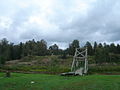 Lohu hill forts
 -

-
 Kohila paper factory
 -
 Pahkla glacial erratic


References[edit]
- ^ "Population figure and composition". [Statistics Estonia]. Retrieved 29 January 2010.
- ^ "Vallast" (in Estonian). [Kohila vald]. Archived from the original on 3 September 2009. Retrieved 29 January 2010.
- ^ "Vallavolikogu" (in Estonian). [Kohila vald]. Retrieved 29 January 2010.
- ^ "Vallavalitsus" (in Estonian). [Kohila vald]. Retrieved 29 January 2010.
External links[edit]
- Official website (in Estonian)
- Electoral coalition "Minu Kohila" (in Estonian)
59°10′5″N 24°45′27″E / 59.16806°N 24.75750°E
| Rural municipalities | ||
|---|---|---|
This Estonia location article is a stub. You can help Wikipedia by expanding it. |