
Langedijk

Langedijk | |
|---|---|
Former municipality | |
 Windmill in Sint Pancras | |
 Flag  Coat of arms | |
.svg) Location of the former municipality of Langedijk in North Holland | |
| Coordinates: 52°41′N 4°48′E / 52.683°N 4.800°E | |
| Country | Netherlands |
| Province | North Holland |
| Municipality | Dijk en Waard |
| Area | |
| • Total | 27.03 km2 (10.44 sq mi) |
| • Land | 23.88 km2 (9.22 sq mi) |
| • Water | 3.15 km2 (1.22 sq mi) |
| Elevation | −1 m (−3 ft) |
| Population (January 2021)[3] | |
| • Total | 28,335 |
| • Density | 1,187/km2 (3,070/sq mi) |
| Time zone | UTC+1 (CET) |
| • Summer (DST) | UTC+2 (CEST) |
| Postcode | 1720–1724, 1830–1834 |
| Area code | 0226, 072 |
| Website | www |
Langedijk (Dutch: [ˌlɑŋəˈdɛik] ⓘ; West Frisian Dutch: Langedìk) is a former municipality in the Netherlands, in the province of North Holland and the region of West-Frisia. Langedijk received city rights in 1415.
Langedijk and the former municipality of Heerhugowaard merged into the new municipality of Dijk en Waard on 1 January 2022.
Population centres[edit]
The former municipality of Langedijk consisted of the following cities, towns, villages and/or districts:
Topography[edit]

Map of the former municipality of Langedijk, 2015
Local government[edit]
The former municipal council of Langedijk consisted of 21 seats, which were divided as follows:
- Kleurrijk Langedijk (5 seats, new party)
- CDA (4 seats)
- PvdA (4 seats)
- VVD (3 seats)
- GroenLinks (2 seats)
- Hart voor Langedijk/D66 (2 seats)
- ChristenUnie (1 seats)
Notable people[edit]

- Johannes Hertenberg (1668 in Oudkarspel – 1725) the 19th Dutch Governor of Ceylon from 1723 until his death
- Theo Nieuwenhuis (1866 in Noord-Scharwoude - 1951) a Dutch watercolor painter, lithograph designer, woodcarver and ceramics and textile designer
- Berend Tobia Boeyinga (1886 in Noord-Scharwoude - 1969) a Dutch architect, noted for his Calvinist church buildings
- Laurens Bogtman (1900 in Oudkarspel – 1969) a Dutch baritone
- Hendrik Jan Marsman (1937 in Sint Pancras – 2012), pen name, J. Bernlef, a Dutch writer, poet, novelist and translator
Sport[edit]
- Jan Langedijk (1910 in Oudkarspel – 1981) a Dutch speed skater who competed at the 1936 and 1948 Winter Olympics
- Gerard Kamper (born 1950 in Koedijk) a retired Dutch cyclist
- Jan Blokhuijsen (born 1989 in Zuid-Scharwoude) Dutch long-track speed skater, silver medallist at the 2014 Winter Olympics
Gallery[edit]
-
 Broekerveiling
 -
 Noord-Scharwoude
 -
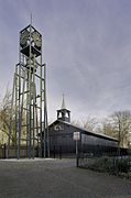 Houten zaalkerk met op de voorgrond een vrijstaande stalen klokkentoren - Koedijk
 -
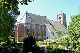 Allemanskerk1 Oudkarspel
 -
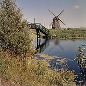 Vergezicht met molen en houten loopbrug - Sint Pancras


References[edit]
- ^ "Kerncijfers wijken en buurten 2020" [Key figures for neighbourhoods 2020]. StatLine (in Dutch). CBS. 24 July 2020. Retrieved 19 September 2020.
- ^ "Postcodetool for 1722GX". Actueel Hoogtebestand Nederland (in Dutch). Het Waterschapshuis. Archived from the original on 21 September 2013. Retrieved 13 March 2014.
- ^ "Bevolkingsontwikkeling; regio per maand" [Population growth; regions per month]. CBS Statline (in Dutch). CBS. 1 January 2021. Retrieved 2 January 2022.
External links[edit]
 Media related to Langedijk at Wikimedia Commons
- Official website
Places adjacent to Langedijk | ||||||||||||||||
|---|---|---|---|---|---|---|---|---|---|---|---|---|---|---|---|---|
| ||||||||||||||||
| Authority control databases: Geographic |
|---|
This North Holland location article is a stub. You can help Wikipedia by expanding it. |