
Merri Creek Trail
This article has multiple issues. Please help improve it or discuss these issues on the talk page. (Learn how and when to remove these messages)
|
37°46′06″S 144°59′03″E / 37.76839°S 144.98405°E
| Merri Creek Trail | |
|---|---|
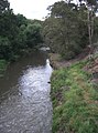
 Looking towards the city at Quarries Park | |
| Length | Approximately 21 km |
| Location | Melbourne, Victoria, Australia |
| Difficulty | Easy |
| Hazards | Some blind corners, steep drop into creek, dog droppings on and beside trail, snakes |
| Surface | Shared use concrete path |
| Hills | Undulating |
The Merri Creek Trail is a shared use path for cyclists and pedestrians that follows the Merri Creek through the northern suburbs of Melbourne, Victoria, Australia.[1][2][3]
History
[edit]The first section of the Trail was opened in 1985 by the Prime Minister of Australia and local member of Parliament, Bob Hawke.[4]
Route
[edit]The path commences at Dights Falls near where Merri Creek enters the Yarra River, and then takes a winding route, mainly following the creek all the way to the Western Ring Road Trail. Hazards include a steep section, unmanageable to all but the most hardy cyclists and close to a school, at Heidelberg Road in Clifton Hill, and a missing section in North Fitzroy that requires leaving the river cutting to cross St. George's Road.
The route is now sealed for its entirety, with the last unsealed sections replaced in 2008. Along the way it passes by CERES, the Brunswick velodrome and the Coburg Lake park.
At the Western Ring Road Trail, heading west leads to the Moonee Ponds Creek Trail, Brimbank Park and the Maribyrnong River Trail. La Trobe University Bundoora campus can be accessed by following the trail east.
Landmarks
[edit]- CERES Community Park
- Brunswick Velodrome
- Coburg Lake
- HM Prison Pentridge
- Merri Creek Labyrinth
Connections
[edit]- The path joins the Western Ring Road Trail in the north.
- In the south, it meets the Yarra River Trail.[5]
- In April 2010, connections to the Capital City Trail were improved with the addition of a new bridge across Merri Creek, 160m south of the junction of Union Street and Merri Parade.[6]
North end at 37°41′41″S 144°58′03″E / 37.694670°S 144.967497°E. South end at 37°46′59″S 144°59′33″E / 37.783139°S 144.992628°E.
Gallery
[edit]-
 Footbridge to Rushall railway station
 -
 Revegetation


References
[edit]- ^ VicRoads - Bicycle Facilities Map Archived 2007-02-19 at the Wayback Machine
- ^ Melbourne and Geelong's shared paths in Google Maps
- ^ Melbourne and Geelong's shared paths in Google Earth
- ^ Schauble, John (18 January 1988). "A Merri chase for the best of navigators". The Age. Retrieved 12 August 2024.
- ^ Kate Morgan (17 September 2013). "Two Minutes with Adalita | Magic Dirt". TheUrbanList.com. Urban List Pty Ltd. Archived from the original on 5 October 2013. Retrieved 6 November 2013.
- ^ Northcote Leader - bridge opening Archived 2011-07-06 at the Wayback Machine
- Bike rides around Melbourne 3rd edition, 2009, Julia Blunden, Open Spaces Publishing, ISBN 978-0-9752333-4-4
- Bike Paths Victoria sixth edition, 2004. Edited and published by Sabey & Associates Pty Ltd. pp124. ISBN 0-9579591-1-7
External links
[edit]- An interactive map of the trail as well as others in the Melbourne area is available here: Walking and Cycling Trails in Melbourne
- Merri Creek Management Committee
- Friends of Merri Creek
- Merri Creek Trail Map: Darebin City Council
 Geographic data related to Merri Creek Trail at OpenStreetMap
This cycling-related article is a stub. You can help Wikipedia by expanding it. |