
Milestone
This article needs additional citations for verification. (June 2008) |


A milestone is one of a series of numbered markers placed along a road or boundary at intervals of one mile or occasionally, parts of a mile. They are typically located at the side of the road or in a median. They are alternatively known as mile markers, mileposts or mile posts (sometimes abbreviated MPs). Mileage is the distance along the road from a fixed commencement point.
Milestones are constructed to provide reference points along the road. This can be used to reassure travellers that the proper path is being followed, and to indicate either distance travelled or the remaining distance to a destination. Such references are also used to by maintenance engineers and emergency services to direct them to specific points where their presence is required. This term is sometimes used to denote a location on a road even if no physical sign is present. This is useful for accident reporting and other record keeping (e.g., "an accident occurred at the 13 mile mark" even if the road is only marked with a stone once every 10 miles).
History
Roman Empire

Milestones were originally stone obelisks – made from granite, marble, or whatever local stone was available – and later concrete posts. They were widely used by Roman Empire road builders and were an important part of any Roman road network: the distance travelled per day was only a few miles in some cases.[citation needed] Many Roman milestones only record the name of the reigning emperor without giving any placenames or distances.[1] The first Roman milestones appeared on the Appian way. At the centre of Rome, the "Golden Milestone" was erected to mark the presumed centre of the empire: this milestone has since been lost. The Golden Milestone inspired the Zero Milestone in Washington, D.C., intended as the point from which all road distances in the United States should be reckoned.
Byzantine Empire

A mile-marker monument, the Milion, was erected in the early 4th century AD in Constantinople. It served as the starting point for measurement of distances for all the roads leading to the cities of the Byzantine Empire, and had the same function as the Milliarium Aureum of Ancient Rome. The Milion survived intact until at least the late 15th century. Its fragments were discovered again in the late 1960s. A fragment is re-erected as a pillar.
Post Medieval Europe
In Europe, the distance measured typically starts at specified point within a city or town, as many roads were named for the towns at either end. For example in London, United Kingdom, a plaque near the Eleanor cross at Charing Cross is the reference point from which distances from London to other towns and cities are measured. In the UK, milestones are especially associated with former Turnpike roads.
Modern highways

The historical term milestone is still used today, even though the "stones" are typically metal[citation needed] signs and in most countries are based on metric rather than imperial units of measure. Also found today are more closely spaced signs containing fractional numbers, and signs along railways, beaches and canals.
Australia
Metrication in Australia caused the former mile markers to be gradually replaced with 10 km markers on highways and country roads, and even these have been removed from most major highways with distances to several towns ahead being shown on signboards. Some mile markers are retained as curiosities (see gallery).
Canada
Usage varies by province, as highways are under provincial jurisdiction. In Alberta, for example, kilometre markers are green metal signs with white lettering, and are generally placed every 4 km starting at the last major intersection to the south or west, depending on whether the route runs north-south or east-west.
India
Milestones on Indian highways typically have white backgrounds with yellow tops (on national highways) or green tops (on state highways). The names of cities and distances are painted in black. The names of the nearest towns and cities are written along with distance in kilometres. On undivided highways, both sides of the milestones are used, telling the distance to the nearest cities in each direction. The highway number is written on the head of the milestone. The sum of the distances of two nearest cities in each direction from the milestone is listed on the side.
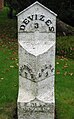
United Kingdom
Although British road signs give distances in miles,British motorways have been marked out in kilometres since the 1980s.[2] Plastic marker posts are installed at 100 m (approximately 5 chain) intervals. Since the advent of the mobile phone, much larger driver location signs have been erected to assist drivers when calling the emergency services.
United States
In the U.S. Interstate Highway System, the numbers usually measure the distance to the southern or western state line, while other highways use the county line as the benchmark.[citation needed] Often, the exits are numbered according to the nearest milepost, known as the mile-log system. Some historic and scenic routes – such as along the Blue Ridge Parkway in North Carolina and Virginia and the Overseas Highway of the Florida Keys – use mileposts to mark points of interest.
Zimbabwe
Zimbabwean milestones are constructed of cast concrete painted white with the kilometre distance indented and painted black.[3] There is no distinction between state and national road-sign markings. They were originally sited every 500 metres by the Rhodesian Ministry of Roads and Road Traffic, starting at zero from the largest town or city. In 1980 the Zimbabwean government began placing new markers 1 km apart and damaged or missing half kilometre markers were no longer replaced.
Railway mileposts

In 1845, the Railways Clauses Consolidation Act[4] was passed, compelling UK railway companies to provide their passengers with a means of determining the distance traveled (fares were set by distance at this time). Section 94 states:
"The company shall cause the length of the railway to be measured, and milestones, posts, or other conspicuous objects to be set up and maintained along the whole line thereof, at the distance of one quarter of a mile from each other, with numbers or marks inscribed thereon denoting such distances."[5]
Similar laws were passed in other countries. On the modern railway, these historical markers are still used as infrastructure reference points. At many points, the distances shown on the markers are based upon points no longer on the network – for example, distances measured via a closed line or from a junction which has subsequently been moved. Whole mileposts are usually supplemented by half and quarter posts. Structure signs often include the mileage to a fair degree of precision; in the UK, a chain is the usual accuracy. In the U.S. and Canada, miles are "decimalized", so that, for example, there may be a "milepost 4.83" to mark a junction or crossing.
In metricated areas, the equivalent is the "point kilométrique".
Boundaries
Surveyors place milestones to mark the boundaries between the jurisdictions separated by borders. A series of such boundary markers exists at one mile (1.6 km) intervals along the borders of the District of Columbia in the United States.
Gallery
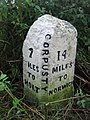
- UK milestones
-
A milestone on the old route of the A148, close to the center of Holt, Norfolk. Note the measurement in furlongs.
-
The other side of the same milestone in Holt
-
A milestone on the A148 in the village of High Kelling
-
The other side of the same milestone in High Kelling
-
A milestone on the A140 in Horsham St. Faith
-
-
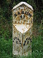
 A milestone on road A342 in St. Edith's Marsh, Bromham, Wiltshire
 -

-
 Milestone on the B3318 in Penwith, Cornwall
 -
-

-
 Milestone on B5500, in the township of Balterley, Staffordshire


- Indian milestones
-
 A milestone near Haridwar on an Indian highway

- United States milestones
-
 1774 Caleb Aldrich milestone on Great Road in Rhode Island, United States
 -

-
 Milestone 8 on the Upper Boston Post Road in Harvard Square, Massachusetts, United States


- Australian milestones
-
 Milepost 18 from Batemans Bay, New South Wales, now preserved in the town. 35°42′05″S 150°10′53″E / 35.7014°S 150.1815°E

.JPG)
.JPG)
.JPG)
.JPG)
See also
- Parting stone
- Boundary marker
- California postmile
- Milepost equation
- Reassurance marker – a road sign with a route number, but no distance
- survey marker
- Highway route markers
- Kilometre Zero
References
- ^ Collingwood, R. G. (1965). The Roman Inscriptions of Britain. I: Inscriptions on stone. Oxford: Clarendon Press.
{{cite book}}: Unknown parameter|coauthor=ignored (|author=suggested) (help) - ^ Highways Agency. "Driver Location Signs - Frequently Asked Questions". Retrieved 10 February 2010.
- ^ "Poultney Family - Mort's Tree". Retrieved 13 April 2012.
The kilometre marker near the tree - distance from Bulawayo [Photo caption]
{{cite web}}: Text "5 September 2009" ignored (help) - ^ "94 Milestones". Railways Clauses Consolidation Act 1845. Retrieved 3 November 2008.
- ^ "Section 26: Distance Markers". Railway Signs and Signals of Great Britain. Retrieved 8 April 2007.
External links
- The Milestone Society UK
- Mileposts and milestones on the Leeds Liverpool Canal
- Article in Smith's Dictionary of Greek and Roman Antiquities with further links, including to a photograph of a Roman milestone in Orvieto
- Inventory of Roman milestones in France (in French)
- Section 2D.46 of the U.S. Manual on Uniform Traffic Control Devices
- MileStonesGurus a weblog pictures project with only milestones with an equal KM point