
Montmorenci, Indiana
Montmorenci, Indiana | |
|---|---|
 Montmorenci's grain elevators silhouetted at dusk | |
 Location of Montmorenci in Tippecanoe County, Indiana. | |
| Coordinates: 40°28′09″N 87°01′06″W / 40.46917°N 87.01833°W | |
| Country | United States |
| State | Indiana |
| County | Tippecanoe |
| Township | Shelby |
| Area | |
• Total | 1.59 sq mi (4.13 km2) |
| • Land | 1.59 sq mi (4.12 km2) |
| • Water | 0.00 sq mi (0.01 km2) |
| Elevation <[2] | 692 ft (211 m) |
| Population (2020) | |
• Total | 173 |
| • Density | 108.74/sq mi (41.99/km2) |
| Time zone | UTC-5 (Eastern (EST)) |
| • Summer (DST) | UTC-4 (EDT) |
| ZIP code | 47906[3] |
| Area code | 765 |
| GNIS feature ID | 2583460[2] |
Montmorenci is an unincorporated census-designated place in Shelby Township, Tippecanoe County, Indiana.[2] Older maps sometimes spell the name Montmorency or Montmorencie.
It is part of the Lafayette, Indiana Metropolitan Statistical Area.
History
[edit]An old variant name of the community was called Bringham's Grove.[4]
A post office was established under the name Bringham's Grove in 1846, and was renamed to Montmorenci in 1853. It is currently not in operation.[5]
Geography
[edit]Montmorenci is located at 40°28'28" North, 87°01'46" West (40.474444, -87.029444) in Shelby Township, at the intersection of U.S. Routes 52 and 231. It has an elevation of 699 feet.
Demographics
[edit]| Census | Pop. | Note | %± |
|---|---|---|---|
| 2020 | 173 | — | |
| U.S. Decennial Census[6] | |||
Education
[edit]A brick school was built in 1913 at a cost of $40,000.[7] By 1923, this school housed classes from grades 1 to 12, and all other schools in the immediate district closed. Montmorenci School met a similar fate in 1966, closing as part of a consolidation that moved the upper grades into the new Benton Central Jr./Sr. High School.
Even though Montmorenci is in Tippecanoe County, all public education is provided by the Benton Community School Corporation from neighboring Benton County. Students attend Otterbein Elementary in grades K-6, then move on to Benton Central Junior-Senior High School in grades 7-12.
-
 The old Montmorenci School building.
 -
 Montmorenci in 1878.
 -
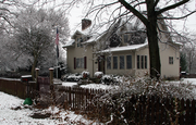 A home along Walnut Street.


References
[edit]- ^ "2020 U.S. Gazetteer Files". United States Census Bureau. Retrieved March 16, 2022.
- ^ a b c U.S. Geological Survey Geographic Names Information System: Montmorenci, Indiana
- ^ "USPS.com® - ZIP Code Lookup". usps.com.
- ^ "USGS detail on Montmorenci - Variant Citation". Retrieved July 25, 2016.
- ^ "Tippecanoe County". Jim Forte Postal History. Retrieved July 25, 2016.
- ^ "Census of Population and Housing". Census.gov. Retrieved June 4, 2016.
- ^ https://sites.rootsweb.com/~intcags/Schools/Shelby%20township%20_early_schools%20of%20TC.html [bare URL]
Municipalities and communities of Tippecanoe County, Indiana, United States | ||
|---|---|---|
| Cities |  | |
| Towns | ||
| Townships | ||
| CDPs | ||
| Other communities | ||
| Ghost towns | ||
| Footnotes | ‡This populated place also has portions in an adjacent county or counties | |