
Nandaprayag
Nandaprayag | |
|---|---|
Town | |
 The Nandakini River (foreground) meets the Alaknanda River (background) in Nandaprayag | |
 Nandaprayag Location in Uttarakhand, India | |
| Coordinates: 30°20′N 79°20′E / 30.33°N 79.33°E | |
| Country | |
| State | Uttarakhand |
| District | Chamoli |
| Elevation | 914 m (2,999 ft) |
| Population (2001) | |
| • Total | 1,433 |
| Languages | |
| • Official | Hindi , Garhwali |
| Time zone | UTC+5:30 (IST) |
| PIN | 246449[1] |
Nandaprayag is a town and a nagar panchayat in Chamoli district in the Indian state of Uttarakhand. Nandaprayag is one of the Panch Prayag (five confluences) of Alaknanda River and lies at the confluence of the Alaknanda River and Nandakini River.[2] Nandaprayag was once the capital of the Yadu kingdom.
Geography[edit]
Nandaprayag is located at 30°20′N 79°20′E / 30.33°N 79.33°E. It has an average elevation of 1,358 metres (4,455 feet). The 538 km long NH 58, connecting NCR with the holy shrine Badrinath and the Mana pass near Indo-Tibet border, pass through this quaint town. The town is nestled in the mountainous terrain overlooking the confluence or holy "Prayag".
Demographics[edit]
As of 2001[update] India census,[3] Nandaprayag had a population of 1433. Males constitute 56% of the population and females 44%. Nandaprayag has an average literacy rate of 70%, higher than the national average of 59.5%: male literacy is 78%, and female literacy is 61%. In Nandaprayag, 13% of the population is under 6 years of age.
Hydro Electric Project[edit]
Uttarakhand Jalvidyut UJVN, a government of Uttarakhand enterprise, is working on the Bowala Nand Prayag Hydro Electric Power Project. The project with a proposed installation of 300 MW (4 x 75 MW) is envisaged to generate an annual energy generation of 1102 MU in a 90% dependable year.[4]
Salient Features
- Location - Chamoli district, Uttarakhand
- River – Alaknanda
- Capacity - 300 MW
- Barrage - 5 Nos. of gates of size 11.0 x 8.0 m
- Head Race Tunnel - 10.05 Km, 9.3 m dia Horse Shoe
- Surge shaft - 27 m dia underground restricted orifice of 80.0 m height
- Penstock - 4 Nos., 3.0 m dia, each
- Surface Power House - size 120m long x 22.2 m wide x 44 m high
- Generator 4 units of 75 MW each
- Francis Turbine - 4 Nos. of Vertical
- Rated head - 138.9 m
- Project land – 62.0 Ha
- Annual Generation - 1343.1 MU
- Project Cost - 2226.56 crores on Feb, 2015 PL
- Year of Commissioning/Completion Schedule - Dec 2022


Gallery[edit]
-
 Another view of the confluence of the Nandakini River (foreground) and the Alaknanda River (background) at Nandprayag
 -
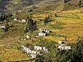 Bangali village near Nandprayag.


References[edit]
- ^ "Nandprayag Pin code". pin-code.net. Retrieved 31 July 2021.
- ^ Uttaranchal. Rupa & Co. 2006. ISBN 81-291-0861-5. Page 12
- ^ "Census of India 2001: Data from the 2001 Census, including cities, villages and towns (Provisional)". Census Commission of India. Archived from the original on 16 June 2004. Retrieved 1 November 2008.
- ^ "Welcome to Uttarakhand Jalvidyut Nigam". Archived from the original on 4 August 2018. Retrieved 23 August 2016.
External links[edit]
This article related to a location in the Indian state of Uttarakhand is a stub. You can help Wikipedia by expanding it. |