
Nimmu–Padum–Darcha road
| Nimmu–Padum–Darcha road | |
|---|---|
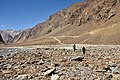
 Chikka & Rarik villages, 6 km from the Darcha terminus, Oct 2020 | |
| Major junctions | |
| North end | Nimmu, Ladakh |
| South end | Darcha, Himachal Pradesh |
| Location | |
| Country | India |
| States | Ladakh, Himachal Pradesh |
| Primary destinations | |
| Highway system | |
Nimmu–Padum–Darcha road or Zanskar Highway[1] is a road under construction between the Indian union territory of Ladakh and the state of Himachal Pradesh, passing through the region of Zanskar. It connects Nimmu in the Indus Valley to Padum, the capital of Zanskar, to Darcha village in Lahul and Spiti.[2] It provides an alternative to the Leh–Manali Highway in linking Ladakh with the rest of India.[3] It is being built by the Border Roads Organisation (BRO) of the Indian army. Construction of road is expected to be completed by late 2023.[4] Already completed Atal tunnel and the under-construction Shingo La Tunnel which will be completed by 2025 will provide all weather connectivity.[5]
It is estimated that travel on this road will only take 10-12 hours to reach Leh from Manali, as opposed to the Leh-Manali highway taking almost 14-16 hours under good weather condition. The road is strategic for the Indian Army as it is set back the international border and can facilitate safe troop movements.[3]
History

The regions of Lahul (Lha yul) and Spiti (sPi ti) were earlier part of Ladakh.[6] They were attached to Zanskar.[7]
By 1847, when the British Raj arrived, they got separated from Ladakh and came under the control of British Punjab. Thus the connections between Zanskar and Lahul and Spiti were partly severed.[8][a] Nevertheless, Lahaulis fought for the defence of Ladakh and Zanskar during the Indo-Pakistani War of 1947–1948. Major Prithi Chand trekked over the Zoji La pass in winter to arrive in Leh before the raiders from Gilgit.[9]
Further separation ensued in 1979 when Ladakh was divided into two districts by the state of Jammu and Kashmir, with Zanskar being made part of the Muslim-majority Kargil district.[10]
The stretch of the road between Nimmu and Padum, called the Chadar Road, was begun by the Jammu and Kashmir Public Works Department in the 1970s.[11] But it was reportedly cancelled by a member of the Legislative Assembly from Srinagar to block linkage between Zanskar and Leh. Zanskar being Buddhist, the politicians of Kargil had apprehensions that it might eventually come under Leh's jurisdiction. So, instead of the Chadar Road, a road between Kargil and Padum was constructed.[12]
Following the Kargil War in 1999, the unfinished Chadar Road project was handed over to the Border Roads Organisation (BRO).[11][13] Trekkers on the Chadar trek (the frozen Zanskar River during winters) perceived the planned road as spoiling the wild and pristine environment. The central government questioned the state of Jammu and Kashmir in 2007 as to its need. The councillor of the Lingshed constituency replied that it was a "right" and a necessity for the development of the remote and backward villages of the region.[12]
In September 2020, the Border Roads Organisation reported that only a 30-kilometre stretch of the road remained to be completed.[3]
Route


Nimmu terminus to Padum
Total distance from Nimmo to Padum is 155 km on the proposed alignment, only 30 km remains to be commissioned. This section covers following towns/villages:
Padum to Shingo La pass
From Padum, the road runs south along the Tsarap Lingti Chu river up to Purne, a distance of 53 km (33 mi).[15] At Purne, the road crosses the river and continues along the Kargiakh Chu, a left bank tributary of the Tsarap up to Lakhang Sumdo. This distance of 39 km (24 mi) has a gentle gradient.[16] Thereafter, the road climbs steeply from 4,460 m (14,630 ft) up to the Shingo La pass at 5,091 m (16,703 ft), covering a distance of 10.5 km (6.5 mi).[17] The total distance covered in this segment is 102.5 km (63.7 mi).
-
 Road from Shingo La down towards Lakang Sumdo
 -
 Road from Kargyak south to Gonbo Rangjon
 -
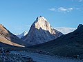
 Kargyak, view from south
 -
 Confluence at Purne


Shingo La to Darcha terminus
The newly-surfaced road (as of Oct '21) continues from the Shingo La pass down to the Darcha terminus. The road descends on the right bank of the Jankar Nala through Ramjak to Zanskar Sumdo, which has a helipad. The Jankar Nala enters a short gorge about 100 ft (30 m) deep. On the sides of the gorge is a Buddhist shrine to the deity Palden Lhamo. The road crosses the gorge and runs along the left bank via Chikka and Rarik to meet the Leh-Manali Highway about 2 km before Darcha. This segment covers a distance of approximately 38 km (24 mi).[18]
-
 Ramjak up to Shingo Ri, road left to centre, Oct '20
 -
 Road from right to centre, down Jankar Nala near Ramjak, Oct '20
 -
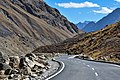
 Cyclists on under-construction road to Shingo La pass, Oct '20
 -
 Road construction near Zanskar Sumdo, Oct '20
 -
 Construction accident, Oct '20
 -
 Newly-surfaced road below Zanskar Sumdo, Oct '20
 -
 Gorge, bridge and shrine at Palden Lhamo, Oct '20
 -
 Jankar Nala gorge, Oct '20
 -
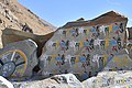 Buddhist prayer stones, Oct '20


See also
Notes
- ^ Lahul was separated from Ladakh at the end of the Tibet–Ladakh–Mughal War (1679–1684) and Upper Kinnaur was annexed to Bashahr. Spiti was annexed to British India after the Treaty of Amritsar through a poorly documented transaction.
References
- ^ Demenge, The Political Ecology of Road Construction (2011), p. 80, note 59.
- ^ Demenge, The Political Ecology of Road Construction (2011), p. 26.
- ^ a b c Manjeet Singh Negi (6 September 2020). "Ground report: India's 'untraceable' road connecting Manali-Leh to allow hassle-free troop movement". India Today.
- ^ Ghoshal, Devjyot (29 September 2020). "High road at Chilling: India builds Himalayan bridges and highways to match China". Reuters.
- ^ Defence ministry clears the BRO tunnel under Shinkun La in Ladakh, Hindustan Times, 19 May 2021.
- ^ Powers, John; Templeman, David (2012), Historical Dictionary of Tibet, Scarecrow Press, p. 387, ISBN 978-0-8108-7984-3: "In the past, La dwags [Ladakh] sometimes included sBal ti yul (Baltistan); Zangs dkar [Zanskar]; Lahaul; Spiti; the Aksai Chin (Hin. Aksä'i cina; Ch. Akesai Qin); and mNga' ris [Ngari]."
- ^ Fisher, Margaret W.; Rose, Leo E.; Huttenback, Robert A. (1963), Himalayan Battleground: Sino-Indian Rivalry in Ladakh, Praeger, pp. 18–19 – via archive.org: "The Ladakhi chronicles state that the eldest son [of King Nyimagon], Pal-gyi-gön [Lhachen Palgyigon], received Ladakh and the Rudok area; the second son, Tra-shi-gön [Trashigon], Guge and Purang; while the third son, De-tsuk-gön [Detsukgon], was given Zanskar, Spiti and Lahul."
- ^ Cunningham, Alexander (1854), Ladak: Physical, Statistical, Historical, London: Wm. H. Allen and Co, p. 18 – via archive.org: "Ladak is divided politically between Maharaja Gulab Sing and the East-India Company. To the former belong all the northern districts, to the latter only the two southern districts of Lahul and Spiti."
- ^ Gutschow, Kim (2006). "The Politics of Being Buddhist in Zangskar: Partition and Today". India Review. 5 (3–4): 470–498. doi:10.1080/14736480600939306. ISSN 1473-6489. S2CID 42308945.
- ^ Demenge, The Road to Lingshed (2013), pp. 52–53.
- ^ a b Demenge, The Road to Lingshed (2013), p. 52.
- ^ a b Demenge, The Road to Lingshed (2013), p. 53.
- ^ Demenge, The Political Ecology of Road Construction (2011), p. 80: "The road under construction passed into BRO hands in 2001, following the war and the recommendations of the Kargil Committee. It was already under construction for civilian purposes but the war demonstrated the need for all-year-round access to Ladakh to move troops and supplies to the Pakistani front, as opposed to the existing roads that were closed for five to six months in winter."
- ^ "Connecting Ladakh: India's growing road network to link borders with the mainland".
- ^ "Padum-Purne route". OpenStreetMap. Retrieved 5 Nov 2022.
- ^ "Purne-Shingo La route". OpenStreetMap. Retrieved 5 Nov 2022.
- ^ "Shingo La". OpenStreetMap. Retrieved 5 Nov 2022.
- ^
"Padum–Darcha route". OpenStreetMap. Retrieved 5 Nov 2022.
{{cite web}}: CS1 maint: url-status (link)
Bibliography
- Demenge, Jonathan (2011), The Political Ecology of Road Construction in Ladakh (PDF), University of Sussex
- Demenge, Jonathan (2013), "The Road to Lingshed: Manufactured Isolation and Experienced Mobility in Ladakh", Himalaya: The Journal of the Association for Nepal and Himalayan Studies, 32 (1): 51–60